
پەڕگە:Irish Sea – relief, ports, limits.tif

Size of this JPG preview of this TIF file: ٤١٥ لە ٦٠٠ پیکسەڵ. ڕێزەلووشنەکانی تر: ١٦٦ لە ٢٤٠ پیکسەڵ | ٣٣٢ لە ٤٨٠ پیکسەڵ | ٥٣١ لە ٧٦٨ پیکسەڵ | ١٬٠٤٣ لە ١٬٥٠٧ پیکسەڵ.
پەڕگەی سەرەکی (١٬٠٤٣ × ١٬٥٠٧ پیکسڵ، قەبارەی پەڕگە: ٤٫٥ مێگابایت، جۆری ئێم ئای ئێم ئی: image/tiff)
کورتە
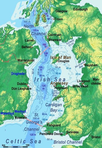
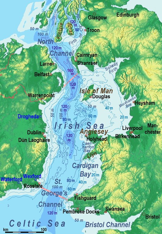
| وەسف | Bathysmographic map of the en:Irish Sea. Major ports shown with red marks. freight-only ports in blue. |
| ڕێکەوت | |
| سەرچاوە | بەرھەمی خۆم, the countures of depth are drawn by myself according to the UK source, the areal colours are derived from the Irish one. The land is from Maps for Free. |
| بەرھەمھێنەر | Ulamm (talk) |
| وەشانەکانی تر |
Sources of information
- internal report Nr. 174 of the National Oceanography Centre (Liverpool)
- http://www.dcenr.gov.ie (Department of Communications, Energy and Natural Resources) -> IOSEA4Annex–Master–r02–Fiinal.pdf (Fourth Strategic Environmental Assessment for Oil and Gas ACtivity in Irelands Offshore Waters) -> figures 2.1 & 2.2a
مۆڵەتنامە
من، ھەڵگری مافی لەبەرگرتنەوەی ئەم بەرھەمە، لەژێر ئەم مۆڵەتنامەیەدا بڵاوی دەکەمەوە:
ئەم پەڕگەیە لە ژێر مۆڵەتنامەی
Creative Commons Attribution-Share Alike 3.0 Unported دایە.
- تۆ ئازادی:
- بۆ بڵاکردنەوە – بۆ کۆپی کردن، دابەشکردن و دەستبەدەست ناردنی
- بۆ تێکەڵکردنەوە – بۆ سازاندنی کارەکە
- بەم مەرجانەی خوارەوە:
- دانەپاڵ – پێویستە باوەڕی گونجاو بدەیت، بەستەرێک بۆ مۆڵەتەکە دابین بکەیت و ئاماژە بەوە بکەیت کە ئایا گۆڕانکاری کراوە یان نا. دەتوانیت بە هەر شێوەیەکی گونجاو ئەوە بکەیت، بەڵام بە شێوەیەک نا کە وا دەربکەوێت کە مۆڵەتدەر پشتگیری تۆ یان بەکارهێنانەکەت بکات.
- بڵاوکردنەوەی گونجاو – ئەگەر لەسەر بنەمای ئەم کارە تێکەڵ، گۆڕان، یان ساز بکەی، پێویستە بەشدارییەکانت بە هەمان مۆڵەت یان هاوشێوەی مۆڵەتی ئەسڵی دابەش بکەی.
مێژووی پەڕگە
کرتە بکە لەسەر یەکێک لە ڕێکەوت/کاتەکان بۆ بینینی پەڕگەکە بەو شێوەی لەو کاتەدا بووە.
| ڕێکەوت/کات | ھێما | ئەندازە | بەکارھێنەر | تێبینی | |
|---|---|---|---|---|---|
| هەنووکە | ١٥:١٧، ١٤ی کانوونی یەکەمی ٢٠١٤ |  | ١٬٠٤٣ لە ١٬٥٠٧ (٤٫٥ مێگابایت) | Ulamm | {{Information |Description = Bathysmographic map of the en:Irish Sea. Major ports shown with red marks. freight-only ports in blue. |Source = {{own}}, the countures of depth are drawn by myself according to the UK source, the areal colours are der... |
بەکارھێنانی پەڕگە
ئەم پەڕەیە ئەم پەڕگەیە بەکار دەھێنێت:
بەکارھێنانی سەرانسەریی پەڕگە
ئەم ویکیانەی دیکەی خوارەوەش ئەم پەڕگە بەکاردێنن:
- بەکارھێنان لە azb.wikipedia.org
- بەکارھێنان لە bh.wikipedia.org
- بەکارھێنان لە de.wikipedia.org
- بەکارھێنان لە en.wikipedia.org
- بەکارھێنان لە eu.wikipedia.org
- بەکارھێنان لە frr.wikipedia.org
- بەکارھێنان لە fr.wikipedia.org
- بەکارھێنان لە fy.wikipedia.org
- بەکارھێنان لە gl.wikipedia.org
- بەکارھێنان لە hsb.wikipedia.org
- بەکارھێنان لە li.wiktionary.org
- بەکارھێنان لە lv.wikipedia.org
- بەکارھێنان لە nl.wikipedia.org
- بەکارھێنان لە pt.wikipedia.org
- بەکارھێنان لە sr.wikipedia.org
- بەکارھێنان لە sw.wikipedia.org
- بەکارھێنان لە th.wikipedia.org
- بەکارھێنان لە uz.wikipedia.org
- بەکارھێنان لە vi.wikipedia.org
- بەکارھێنان لە vls.wikipedia.org