
پەڕگە:Super Pit Mine, Kalgoorlie, Western Australia.jpg

قەبارەی ئەم پێشبینینە: ٦٠٠ لە ٦٠٠ پیکسەڵ. ڕێزەلووشنەکانی تر: ٢٤٠ لە ٢٤٠ پیکسەڵ | ٤٨٠ لە ٤٨٠ پیکسەڵ | ٧٦٨ لە ٧٦٨ پیکسەڵ | ١٬٠٢٤ لە ١٬٠٢٤ پیکسەڵ | ٢٬٠٤٨ لە ٢٬٠٤٨ پیکسەڵ | ٣٬٠٠٠ لە ٣٬٠٠٠ پیکسەڵ.
پەڕگەی سەرەکی (٣٬٠٠٠ × ٣٬٠٠٠ پیکسڵ، قەبارەی پەڕگە: ٣٫٤٦ مێگابایت، جۆری ئێم ئای ئێم ئی: image/jpeg)
کورتە
| وەسف |
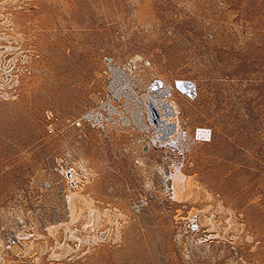
English: The pit that gives the mine its name appears in the centre of the image, and some of the steep pit’s walls appear in shadow while others are illuminated by the Sun. Related mining operations form a rough semicircle on the eastern side of the pit; a cluster of buildings east-north-east of the pit is Fimiston Mill, where ore is processed. Waste dumps and grey-white tailings ponds sprawl over the arid landscape. Tailings are the rocks and chemicals left over after the gold is extracted. Because the chemicals used to separate gold from rock are often caustic, tailings usually pose hazards to human and/or environmental health and must be treated carefully. The metropolitan area of Kalgoorlie, marked by street grids and manicured green spaces, extends almost to the mine’s central pit. An airport, marked by a long runway, appears along the city’s southern margin. Founded during a late-nineteenth-century gold rush, Kalgoorlie, like the neighboring mine, occurs near an area nicknamed the “Golden Mile,” which is considered especially rich in gold deposits. As the beige and reddish colors in the image indicate, vegetation in the area is sparse. |
| ڕێکەوت | |
| سەرچاوە | NASA Earth Observatory |
| بەرھەمھێنەر | Jesse Allen |
Image captured by the Advanced Land Imager (ALI) on NASA’s Earth Observing-1 (EO-1) satellite. Data provided courtesy of the NASA EO-1 team.
مۆڵەتنامە
| This file is in the public domain in the United States because it was solely created by NASA. NASA copyright policy states that "NASA material is not protected by copyright unless noted". (See Template:PD-USGov, NASA copyright policy page or JPL Image Use Policy.) | ||
 |
Warnings:
|
| Annotations | This image is annotated: View the annotations at Commons |
مێژووی پەڕگە
کرتە بکە لەسەر یەکێک لە ڕێکەوت/کاتەکان بۆ بینینی پەڕگەکە بەو شێوەی لەو کاتەدا بووە.
| ڕێکەوت/کات | ھێما | ئەندازە | بەکارھێنەر | تێبینی | |
|---|---|---|---|---|---|
| هەنووکە | ١٢:١١، ٢٢ی شوباتی ٢٠١٠ | | ٣٬٠٠٠ لە ٣٬٠٠٠ (٣٫٤٦ مێگابایت) | Originalwana | {{Information |Description={{en|1=The pit that gives the mine its name appears in the centre of the image, and some of the steep pit’s walls appear in shadow while others are illuminated by the Sun. Related mining operations form a rough semicir |
بەکارھێنانی پەڕگە
ئەم پەڕەیە ئەم پەڕگەیە بەکار دەھێنێت:
بەکارھێنانی سەرانسەریی پەڕگە
ئەم ویکیانەی دیکەی خوارەوەش ئەم پەڕگە بەکاردێنن:
- بەکارھێنان لە cs.wikipedia.org
- بەکارھێنان لە en.wikipedia.org
- بەکارھێنان لە fa.wikipedia.org
- بەکارھێنان لە fr.wikipedia.org
- بەکارھێنان لە nl.wikipedia.org
- بەکارھێنان لە www.wikidata.org