
پەڕگە:Satellite image of Norway in February 2003.jpg

قەبارەی ئەم پێشبینینە: ٥١١ لە ٦٠٠ پیکسەڵ. ڕێزەلووشنەکانی تر: ٢٠٤ لە ٢٤٠ پیکسەڵ | ٤٠٩ لە ٤٨٠ پیکسەڵ | ٦٥٤ لە ٧٦٨ پیکسەڵ | ٨٧٣ لە ١٬٠٢٤ پیکسەڵ | ١٬٧٤٥ لە ٢٬٠٤٨ پیکسەڵ | ٤٬٩٦٠ لە ٥٬٨٢٠ پیکسەڵ.
پەڕگەی سەرەکی (٤٬٩٦٠ × ٥٬٨٢٠ پیکسڵ، قەبارەی پەڕگە: ٥٫٨١ مێگابایت، جۆری ئێم ئای ئێم ئی: image/jpeg)
کورتە
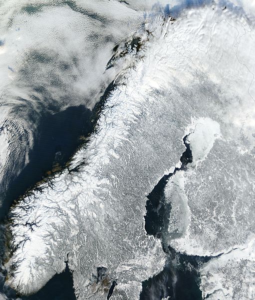
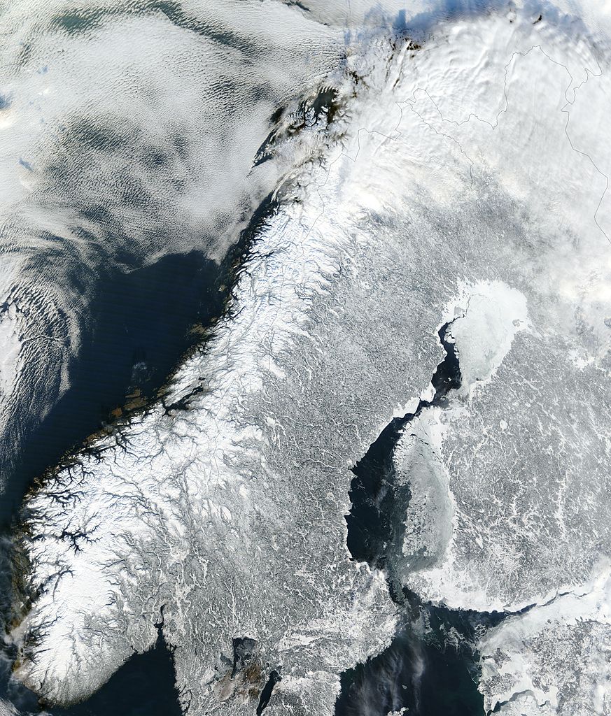
| وەسف | Satellite image of continental Norway in February 2003. |
| ڕێکەوت | |
| سەرچاوە | Cropped from original http://visibleearth.nasa.gov/view_rec.php?id=4991 |
| بەرھەمھێنەر | Jacques Descloitres, MODIS Rapid Response Team, NASA/GSFC |
| وەشانەکانی تر |
|

مۆڵەتنامە
| This file is in the public domain in the United States because it was solely created by NASA. NASA copyright policy states that "NASA material is not protected by copyright unless noted". (See Template:PD-USGov, NASA copyright policy page or JPL Image Use Policy.) | ||
 |
Warnings:
|
مێژووی پەڕگە
کرتە بکە لەسەر یەکێک لە ڕێکەوت/کاتەکان بۆ بینینی پەڕگەکە بەو شێوەی لەو کاتەدا بووە.
| ڕێکەوت/کات | ھێما | ئەندازە | بەکارھێنەر | تێبینی | |
|---|---|---|---|---|---|
| هەنووکە | ١٧:٤٠، ٢٣ی کانوونی دووەمی ٢٠٠٥ | | ٤٬٩٦٠ لە ٥٬٨٢٠ (٥٫٨١ مێگابایت) | Hautala | {{PD-USGov-NASA}} Satellite image of continental Norway in February 2003. Cropped image, original taken from NASA's Visible Earth http://visibleearth.nasa.gov/cgi-bin/viewrecord?24856 |
بەکارھێنانی پەڕگە
ئەم پەڕەیە ئەم پەڕگەیە بەکار دەھێنێت:
بەکارھێنانی سەرانسەریی پەڕگە
ئەم ویکیانەی دیکەی خوارەوەش ئەم پەڕگە بەکاردێنن:
- بەکارھێنان لە af.wikipedia.org
- بەکارھێنان لە ar.wikipedia.org
- بەکارھێنان لە az.wikipedia.org
- بەکارھێنان لە bn.wikipedia.org
- بەکارھێنان لە ca.wikipedia.org
- بەکارھێنان لە da.wikipedia.org
- بەکارھێنان لە de.wikipedia.org
- بەکارھێنان لە el.wikipedia.org
- بەکارھێنان لە en.wikipedia.org
- بەکارھێنان لە es.wikipedia.org
- بەکارھێنان لە et.wikipedia.org
- بەکارھێنان لە fa.wikipedia.org
- بەکارھێنان لە fi.wikipedia.org
- بەکارھێنان لە fr.wikipedia.org
- بەکارھێنان لە gv.wikipedia.org
- بەکارھێنان لە hr.wikipedia.org
- بەکارھێنان لە hu.wikipedia.org
- بەکارھێنان لە id.wikipedia.org
- بەکارھێنان لە it.wikipedia.org
- بەکارھێنان لە jv.wikipedia.org
- بەکارھێنان لە km.wikipedia.org
- بەکارھێنان لە nl.wikipedia.org
- بەکارھێنان لە nn.wikipedia.org
- بەکارھێنان لە nn.wikiquote.org
- بەکارھێنان لە no.wikipedia.org
- بەکارھێنان لە pl.wikipedia.org
- بەکارھێنان لە pt.wikipedia.org
- بەکارھێنان لە ro.wikipedia.org
بینینی بەکارھێنانی گشتی زیاتری ئەم پەڕگەیە.