
پەڕگە:MerguiArchipelagoMap.png
قەبارەی ئەم پێشبینینە: ٣٢٢ لە ٥٩٨ پیکسەڵ. ڕێزەلووشنەکانی تر: ١٢٩ لە ٢٤٠ پیکسەڵ | ٢٥٨ لە ٤٨٠ پیکسەڵ | ٩٧٣ لە ١٬٨٠٨ پیکسەڵ.
پەڕگەی سەرەکی (٩٧٣ × ١٬٨٠٨ پیکسڵ، قەبارەی پەڕگە: ٦١ کیلۆبایت، جۆری ئێم ئای ئێم ئی: image/png)
کورتە
| وەسف |
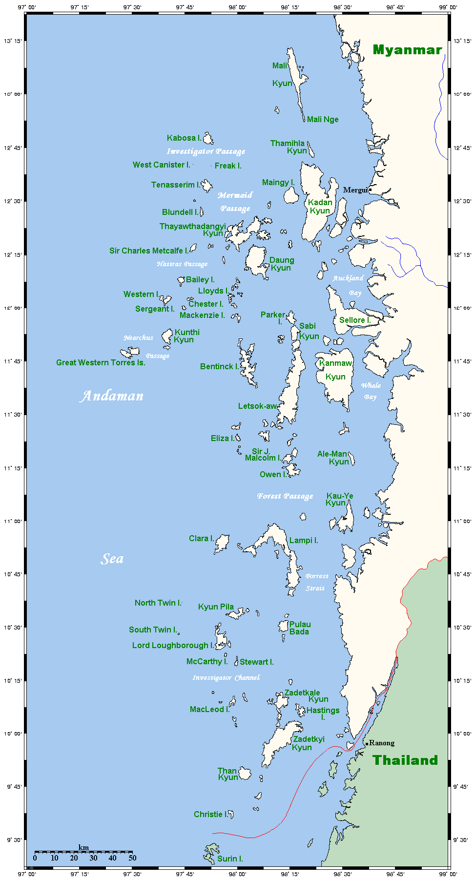
Map of the Mergui Archipelago in Myanmar. This map's source is here, with the uploader's modifications, and the GMT homepage says that the tools are released under the GNU General Public License. There is a somewhat bigger map of this area, showing places farther north and south. This is not on Wikipedia, but leave a message at my talk page if you would like such a thing, and likewise if you know any further information that ought to go on this map. |
| ڕێکەوت | ١٤ی ئایاری ٢٠٠٦ (original upload date) |
| سەرچاوە | Transferred from en.wikipedia to Commons. |
| بەرھەمھێنەر | Kelisi at ئینگلیزی ویکیپیدیا |

|
This map image could be re-created using vector graphics as an SVG file. This has several advantages; see Commons:Media for cleanup for more information. If an SVG form of this image is available, please upload it and afterwards replace this template with
{{vector version available|new image name}}.
It is recommended to name the SVG file “MerguiArchipelagoMap.svg”—then the template Vector version available (or Vva) does not need the new image name parameter. |
مۆڵەتنامە
Kelisi from en.wikipedia.org، ھەڵگری مافی لەبەرگرتنەوەی ئەم بەرھەمە، لەژێر ئەم مۆڵەتنامەیەدا بڵاوی دەکاتەوە:
| ئەم پەڕگەیە لە ژێر مۆڵەتنامەی
Creative Commons Attribution-Share Alike 3.0 Unported دایە. Subject to disclaimers. |
||
| دانەپاڵ: Kelisi from en.wikipedia.org | ||
| ||
| This licensing tag was added to this file as part of the GFDL licensing update. |

|
ڕێگەدراوە بە لەبەرگرتنەوە، دابەشکردن ھەروەھا/یان سازاندنی ئەم بەڵگەنامەیە لەژێر مەرجی مۆڵەتی GNU بۆ بەڵگەنامەی ئازاد، وەشانی ١.٢ یان ھەر وەشانێکی تری دواتر کە بڵاوکراوەتەوە لەلایەن دامەزراوەی بەرنامەی ئازاد، بەبێ ھیچ بەشێکی جیاواز، بەبێ نووسین لەسەر بەرگی پێشەوە و دواوەی. وێنەیەک لەمۆڵەتەکە لە بەشێکدا ھەیە کە ناوی مۆڵەتی GNU بۆ بەڵگەنامەی ئازادە. Subject to disclaimers. |
Original upload log
The original description page was here. All following user names refer to en.wikipedia.
- 2006-05-14 20:32 Kelisi 973×1808×8 (62506 bytes) Map of the Mergui Archipelago in Myanmar. This map's source is [http://www.aquarius.geomar.de/omc/make_map.html here], with the uploader's modifications, and the [http://gmt.soest.hawaii.edu/ GMT homepage] says that the tools are released under the GNU Ge
مێژووی پەڕگە
کرتە بکە لەسەر یەکێک لە ڕێکەوت/کاتەکان بۆ بینینی پەڕگەکە بەو شێوەی لەو کاتەدا بووە.
| ڕێکەوت/کات | ھێما | ئەندازە | بەکارھێنەر | تێبینی | |
|---|---|---|---|---|---|
| هەنووکە | ٢٣:٢٠، ١ی ئایاری ٢٠٠٧ | | ٩٧٣ لە ١٬٨٠٨ (٦١ کیلۆبایت) | Ppntori | {{Information |Description=Map of the Mergui Archipelago in Myanmar. This map's source is [http://www.aquarius.geomar.de/omc/make_map.html here], with the uploader's modifications, and the [http://gmt.soest.hawaii.edu/ GMT homepage] says that the tools ar |
بەکارھێنانی پەڕگە
ئەم پەڕەیە ئەم پەڕگەیە بەکار دەھێنێت:
بەکارھێنانی سەرانسەریی پەڕگە
ئەم ویکیانەی دیکەی خوارەوەش ئەم پەڕگە بەکاردێنن:
- بەکارھێنان لە ar.wikipedia.org
- بەکارھێنان لە arz.wikipedia.org
- بەکارھێنان لە ban.wikipedia.org
- بەکارھێنان لە bcl.wikipedia.org
- بەکارھێنان لە bg.wikipedia.org
- بەکارھێنان لە bh.wikipedia.org
- بەکارھێنان لە bn.wikipedia.org
- بەکارھێنان لە bs.wikipedia.org
- بەکارھێنان لە ca.wikipedia.org
- بەکارھێنان لە cy.wikipedia.org
- بەکارھێنان لە de.wikipedia.org
- بەکارھێنان لە en.wikipedia.org
- بەکارھێنان لە es.wikipedia.org
- بەکارھێنان لە fa.wikipedia.org
- بەکارھێنان لە fi.wikipedia.org
- بەکارھێنان لە fr.wikipedia.org
- بەکارھێنان لە fy.wikipedia.org
- بەکارھێنان لە ga.wikipedia.org
- بەکارھێنان لە hi.wikipedia.org
- بەکارھێنان لە hu.wikipedia.org
- بەکارھێنان لە ia.wikipedia.org
- بەکارھێنان لە id.wikipedia.org
- بەکارھێنان لە ilo.wikipedia.org
- بەکارھێنان لە incubator.wikimedia.org
- بەکارھێنان لە io.wikipedia.org
- بەکارھێنان لە it.wikipedia.org
- بەکارھێنان لە ja.wikipedia.org
- بەکارھێنان لە jv.wikipedia.org
- بەکارھێنان لە kk.wikipedia.org
- بەکارھێنان لە km.wikipedia.org
- بەکارھێنان لە kn.wikipedia.org
- بەکارھێنان لە ko.wikipedia.org
- بەکارھێنان لە lt.wikipedia.org
- بەکارھێنان لە min.wikipedia.org
- بەکارھێنان لە mk.wikipedia.org
- بەکارھێنان لە ml.wikipedia.org
- بەکارھێنان لە mr.wikipedia.org
بینینی بەکارھێنانی گشتی زیاتری ئەم پەڕگەیە.