
پەڕگە:Croatian Prevlaka in occupation by Montenegro and Serbia.jpg
رەزۆلوشنی سەرتر لەمە لە بەردەست دا نیە.
Croatian_Prevlaka_in_occupation_by_Montenegro_and_Serbia.jpg (٧٦٠ × ٥٦٠ پیکسڵ، قەبارەی پەڕگە: ١١٨ کیلۆبایت، جۆری ئێم ئای ئێم ئی: image/jpeg)
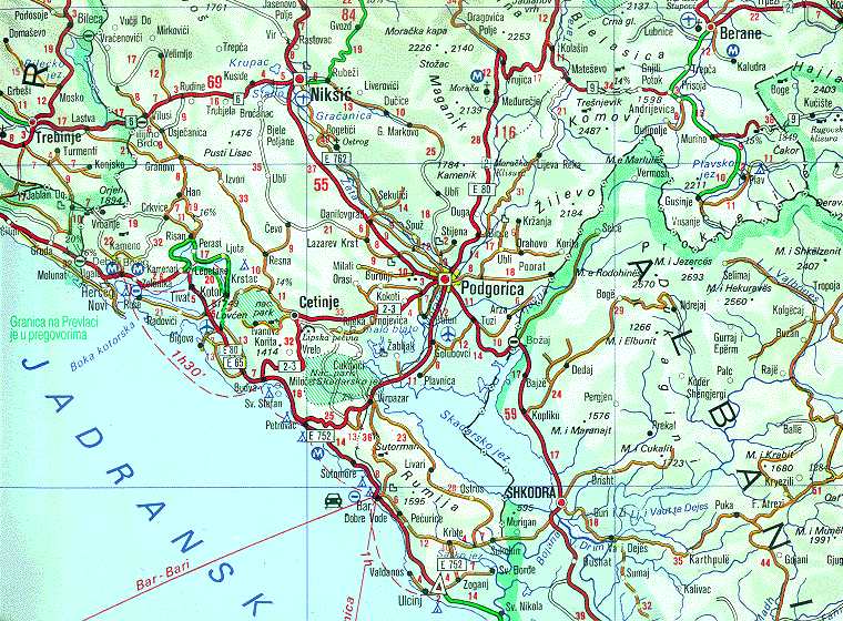
| وەسف | Map of Montenegrin Littoral Region and Boka kotorska in the time of occupation of Croatian Prevlaka Region which is the remaining part of Boka kotorska that belongs to Croatia. | |||
| ڕێکەوت | 1991-2002 (occupation ended 1992-10-20 at 20:30) (UNMIK mission ended 2002-12-20). | |||
| سەرچاوە | Ministry of Foreign Affairs of the State Union Serbia and Montenegro (before that MFA of Federal Republic of Yugoslavia | |||
| بەرھەمھێنەر | Serbian Official Cartography (Public Service at the time). | |||
| ڕێپێدان (بەکارھێنانەوەی ئەم پەڕگەیە) |
|
|||
| وەشانەکانی تر | Geographical version. |

مێژووی پەڕگە
کرتە بکە لەسەر یەکێک لە ڕێکەوت/کاتەکان بۆ بینینی پەڕگەکە بەو شێوەی لەو کاتەدا بووە.
| ڕێکەوت/کات | ھێما | ئەندازە | بەکارھێنەر | تێبینی | |
|---|---|---|---|---|---|
| هەنووکە | ٠٢:٠٥، ١٦ی شوباتی ٢٠٠٨ | | ٧٦٠ لە ٥٦٠ (١١٨ کیلۆبایت) | Imbris~commonswiki | {{Information |Description=Map of Montenegrin ''Littoral Region'' and ''Boka kotorska'' in the time of occupation of Croatian hr:Prevlaka Region which is the remaining part of Boka kotorska that belongs to Croatia. |Source=[http://www.mfa.gov.yu/Fact |
بەکارھێنانی پەڕگە
ئەم پەڕەیە ئەم پەڕگەیە بەکار دەھێنێت:
بەکارھێنانی سەرانسەریی پەڕگە
ئەم ویکیانەی دیکەی خوارەوەش ئەم پەڕگە بەکاردێنن:
- بەکارھێنان لە ca.wikipedia.org
- بەکارھێنان لە de.wikipedia.org
- بەکارھێنان لە en.wikipedia.org
- بەکارھێنان لە fa.wikipedia.org
- بەکارھێنان لە hr.wikipedia.org
- بەکارھێنان لە id.wikipedia.org
- بەکارھێنان لە mzn.wikipedia.org
- بەکارھێنان لە nl.wikipedia.org
- بەکارھێنان لە ru.wikipedia.org
- بەکارھێنان لە sh.wikipedia.org
- بەکارھێنان لە sq.wikipedia.org
- بەکارھێنان لە www.wikidata.org
- بەکارھێنان لە zh.wikipedia.org