
پەڕگە:La Réunion department relief location map.jpg
قەبارەی ئەم پێشبینینە: ٦٤٥ لە ٦٠٠ پیکسەڵ. ڕێزەلووشنەکانی تر: ٢٥٨ لە ٢٤٠ پیکسەڵ | ٥١٦ لە ٤٨٠ پیکسەڵ | ٨٢٦ لە ٧٦٨ پیکسەڵ | ١٬٠٣٧ لە ٩٦٤ پیکسەڵ.
پەڕگەی سەرەکی (١٬٠٣٧ × ٩٦٤ پیکسڵ، قەبارەی پەڕگە: ٢٤٤ کیلۆبایت، جۆری ئێم ئای ئێم ئی: image/jpeg)
کورتە
| Camera location | | View this and other nearby images on: OpenStreetMap |
|---|
| وەسف |
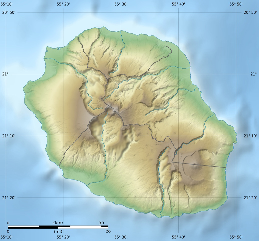
English: Blank physical map of the region and department of Réunion, France, for geo-location purpose.
Français : Carte physique vierge de la région et département de La Réunion, France, destinée à la géolocalisation. Scales: 1:372,000 (precision: 93 m) for the topography; 1:3,760,000 (precision: 940 m) for the bathymetry
Geographic limits of the map:
|
||
| ڕێکەوت | |||
| سەرچاوە |
بەرھەمی خۆم
|
||
| بەرھەمھێنەر | Eric Gaba (Sting - fr:Sting) | ||
| ڕێپێدان (بەکارھێنانەوەی ئەم پەڕگەیە) |
|
||
| وەشانەکانی تر |
Derivative works of this file: Circus maillardi distribution 1973-1975.png
|

مۆڵەتنامە
من، ھەڵگری مافی لەبەرگرتنەوەی ئەم بەرھەمە، لەژێر ئەم مۆڵەتنامەیانەدا بڵاوی دەکەمەوە:
ئەم پەڕگەیە لە ژێر مۆڵەتنامەی
Creative Commons Attribution-Share Alike 3.0 Unported دایە.
- تۆ ئازادی:
- بۆ بڵاکردنەوە – بۆ کۆپی کردن، دابەشکردن و دەستبەدەست ناردنی
- بۆ تێکەڵکردنەوە – بۆ سازاندنی کارەکە
- بەم مەرجانەی خوارەوە:
- دانەپاڵ – پێویستە باوەڕی گونجاو بدەیت، بەستەرێک بۆ مۆڵەتەکە دابین بکەیت و ئاماژە بەوە بکەیت کە ئایا گۆڕانکاری کراوە یان نا. دەتوانیت بە هەر شێوەیەکی گونجاو ئەوە بکەیت، بەڵام بە شێوەیەک نا کە وا دەربکەوێت کە مۆڵەتدەر پشتگیری تۆ یان بەکارهێنانەکەت بکات.
- بڵاوکردنەوەی گونجاو – ئەگەر لەسەر بنەمای ئەم کارە تێکەڵ، گۆڕان، یان ساز بکەی، پێویستە بەشدارییەکانت بە هەمان مۆڵەت یان هاوشێوەی مۆڵەتی ئەسڵی دابەش بکەی.

|
ڕێگەدراوە بە لەبەرگرتنەوە، دابەشکردن ھەروەھا/یان سازاندنی ئەم بەڵگەنامەیە لەژێر مەرجی مۆڵەتی GNU بۆ بەڵگەنامەی ئازاد، وەشانی ١.٢ یان ھەر وەشانێکی تری دواتر کە بڵاوکراوەتەوە لەلایەن دامەزراوەی بەرنامەی ئازاد، بەبێ ھیچ بەشێکی جیاواز، بەبێ نووسین لەسەر بەرگی پێشەوە و دواوەی. وێنەیەک لەمۆڵەتەکە لە بەشێکدا ھەیە کە ناوی مۆڵەتی GNU بۆ بەڵگەنامەی ئازادە. |
دەتوانی مۆڵەتنامەی دڵخوازت ھەڵبژێریت.
مێژووی پەڕگە
کرتە بکە لەسەر یەکێک لە ڕێکەوت/کاتەکان بۆ بینینی پەڕگەکە بەو شێوەی لەو کاتەدا بووە.
| ڕێکەوت/کات | ھێما | ئەندازە | بەکارھێنەر | تێبینی | |
|---|---|---|---|---|---|
| هەنووکە | ١٤:٠٠، ١٨ی تەممووزی ٢٠١٠ | | ١٬٠٣٧ لە ٩٦٤ (٢٤٤ کیلۆبایت) | Sting | Color profile |
| ١٥:٠٦، ٢٣ی ئازاری ٢٠٠٩ |  | ١٬٠٣٧ لە ٩٦٤ (٢١٨ کیلۆبایت) | Sting | == Summary == {{Location|21|07|30|S|55|31|30|E|scale:500000}} <br/> {{Information |Description={{en|Blank physical map of the department of Réunion, France, for geo-location purpose.}} {{fr|Ca |
بەکارھێنانی پەڕگە
ئەم پەڕەیە ئەم پەڕگەیە بەکار دەھێنێت:
بەکارھێنانی سەرانسەریی پەڕگە
ئەم ویکیانەی دیکەی خوارەوەش ئەم پەڕگە بەکاردێنن:
- بەکارھێنان لە als.wikipedia.org
- بەکارھێنان لە am.wikipedia.org
- بەکارھێنان لە ar.wikipedia.org
- بەکارھێنان لە ast.wikipedia.org
- بەکارھێنان لە az.wikipedia.org
- بەکارھێنان لە be.wikipedia.org
- بەکارھێنان لە bg.wikipedia.org
- بەکارھێنان لە bs.wikipedia.org
- بەکارھێنان لە ceb.wikipedia.org
- بەکارھێنان لە ce.wikipedia.org
- بەکارھێنان لە cs.wikipedia.org
- بەکارھێنان لە da.wikipedia.org
- بەکارھێنان لە de.wikipedia.org
- بەکارھێنان لە de.wikivoyage.org
- Saint-Denis (Réunion)
- Cilaos
- Saint-Pierre (Réunion)
- Saint-Leu (Réunion)
- Flughafen Réunion Roland Garros
- Le Port (Réunion)
- Le Tampon
- Saint-Paul (Réunion)
- Piton de la Fournaise
- Saint-Gilles-Les-Bains
- Diskussion:Piton de la Fournaise
- Modul:Location map data re
- Modul:Location map data re/Doku
- Saint-Philippe (Réunion)
- بەکارھێنان لە dsb.wikipedia.org
- بەکارھێنان لە el.wikipedia.org
- بەکارھێنان لە en.wikipedia.org
بینینی بەکارھێنانی گشتی زیاتری ئەم پەڕگەیە.