
پەڕگە:Guyana location map.svg

Size of this PNG preview of this SVG file: ٤٠٧ لە ٥٩٩ پیکسەڵ. ڕێزەلووشنەکانی تر: ١٦٣ لە ٢٤٠ پیکسەڵ | ٣٢٦ لە ٤٨٠ پیکسەڵ | ٥٢٢ لە ٧٦٨ پیکسەڵ | ٦٩٥ لە ١٬٠٢٤ پیکسەڵ | ١٬٣٩١ لە ٢٬٠٤٨ پیکسەڵ | ١٬٢٥٢ لە ١٬٨٤٣ پیکسەڵ.
پەڕگەی سەرەکی (پەڕگەی SVG، بە ناو ١٬٢٥٢ × ١٬٨٤٣ پیکسەڵ، قەبارەی پەڕگە: ٢٩٣ کیلۆبایت)
کورتە
| وەسف |
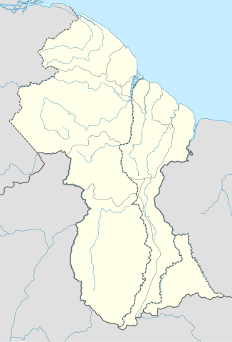
Deutsch: Positionskarte von Guyana
Quadratische Plattkarte. Geographische Begrenzung der Karte:
English: Location map of Guyana
Equirectangular projection. Geographic limits of the map:
|
| ڕێکەوت | 02.12.2008 |
| سەرچاوە |
own work, using
|
| بەرھەمھێنەر | NordNordWest |
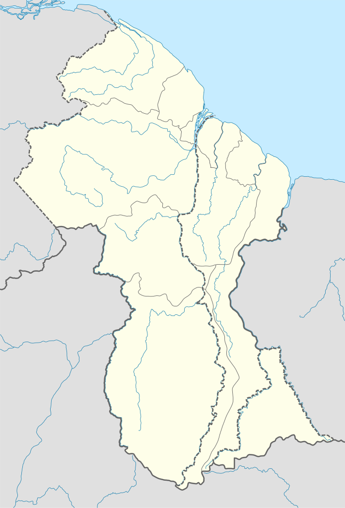
| وەشانەکانی تر | Derivative works of this file: Guyana relief location map.jpg |

|
This map has been made or improved in the German Kartenwerkstatt (Map Lab). You can propose maps to improve as well.
|
مۆڵەتنامە
من، ھەڵگری مافی لەبەرگرتنەوەی ئەم بەرھەمە، لەژێر ئەم مۆڵەتنامەیانەدا بڵاوی دەکەمەوە:

|
ڕێگەدراوە بە لەبەرگرتنەوە، دابەشکردن ھەروەھا/یان سازاندنی ئەم بەڵگەنامەیە لەژێر مەرجی مۆڵەتی GNU بۆ بەڵگەنامەی ئازاد، وەشانی ١.٢ یان ھەر وەشانێکی تری دواتر کە بڵاوکراوەتەوە لەلایەن دامەزراوەی بەرنامەی ئازاد، بەبێ ھیچ بەشێکی جیاواز، بەبێ نووسین لەسەر بەرگی پێشەوە و دواوەی. وێنەیەک لەمۆڵەتەکە لە بەشێکدا ھەیە کە ناوی مۆڵەتی GNU بۆ بەڵگەنامەی ئازادە. |
ئەم پەڕگەیە لە ژێر مۆڵەتنامەی
Creative Commons Attribution-Share Alike 3.0 Unported دایە.
- تۆ ئازادی:
- بۆ بڵاکردنەوە – بۆ کۆپی کردن، دابەشکردن و دەستبەدەست ناردنی
- بۆ تێکەڵکردنەوە – بۆ سازاندنی کارەکە
- بەم مەرجانەی خوارەوە:
- دانەپاڵ – پێویستە باوەڕی گونجاو بدەیت، بەستەرێک بۆ مۆڵەتەکە دابین بکەیت و ئاماژە بەوە بکەیت کە ئایا گۆڕانکاری کراوە یان نا. دەتوانیت بە هەر شێوەیەکی گونجاو ئەوە بکەیت، بەڵام بە شێوەیەک نا کە وا دەربکەوێت کە مۆڵەتدەر پشتگیری تۆ یان بەکارهێنانەکەت بکات.
- بڵاوکردنەوەی گونجاو – ئەگەر لەسەر بنەمای ئەم کارە تێکەڵ، گۆڕان، یان ساز بکەی، پێویستە بەشدارییەکانت بە هەمان مۆڵەت یان هاوشێوەی مۆڵەتی ئەسڵی دابەش بکەی.
دەتوانی مۆڵەتنامەی دڵخوازت ھەڵبژێریت.
مێژووی پەڕگە
کرتە بکە لەسەر یەکێک لە ڕێکەوت/کاتەکان بۆ بینینی پەڕگەکە بەو شێوەی لەو کاتەدا بووە.
| ڕێکەوت/کات | ھێما | ئەندازە | بەکارھێنەر | تێبینی | |
|---|---|---|---|---|---|
| هەنووکە | ١٧:٠٣، ١٥ی ئەیلوولی ٢٠١٧ | | ١٬٢٥٢ لە ١٬٨٤٣ (٢٩٣ کیلۆبایت) | Milenioscuro | corrected disputed border with Venezuela |
| ٠٤:٠٩، ٢٨ی ئەیلوولی ٢٠١٣ |  | ١٬٢٥٢ لە ١٬٨٤٣ (٣٤٢ کیلۆبایت) | Unukalhai | Reverted to version as of 04:34, 16 October 2012 | |
| ١٢:٣٦، ٢٤ی شوباتی ٢٠١٣ |  | ١٬٢٥٢ لە ١٬٨٤٣ (٣٤١ کیلۆبایت) | Wester | Reverted to version as of 19:53, 2 December 2008 | |
| ٠٤:٣٤، ١٦ی تشرینی یەکەمی ٢٠١٢ |  | ١٬٢٥٢ لە ١٬٨٤٣ (٣٤٢ کیلۆبایت) | Unukalhai | Including disputed area by Venezuela, the same way wich the surinamese one appears in the map. http://treaties.un.org/pages/showDetails.aspx?objid=080000028012b96f | |
| ١٩:٥٣، ٢ی کانوونی یەکەمی ٢٠٠٨ |  | ١٬٢٥٢ لە ١٬٨٤٣ (٣٤١ کیلۆبایت) | NordNordWest | {{Information |Description= {{de|Positionskarte von Guyana}} Quadratische Plattkarte. Geographische Begrenzung der Karte: * N: 8.7° N * S: 0.9° N * W: 61.6° W * O: 56.3° W {{en|Location map of Guyana}} Equirectangular pro |
بەکارھێنانی پەڕگە
ئەم پەڕەیە ئەم پەڕگەیە بەکار دەھێنێت:
بەکارھێنانی سەرانسەریی پەڕگە
ئەم ویکیانەی دیکەی خوارەوەش ئەم پەڕگە بەکاردێنن:
- بەکارھێنان لە af.wikipedia.org
- بەکارھێنان لە an.wikipedia.org
- بەکارھێنان لە ar.wikipedia.org
- بەکارھێنان لە ast.wikipedia.org
- بەکارھێنان لە az.wikipedia.org
- بەکارھێنان لە ba.wikipedia.org
- بەکارھێنان لە be-tarask.wikipedia.org
- بەکارھێنان لە be.wikipedia.org
- بەکارھێنان لە bg.wikipedia.org
- بەکارھێنان لە bn.wikipedia.org
- بەکارھێنان لە bs.wikipedia.org
- بەکارھێنان لە ceb.wikipedia.org
بینینی بەکارھێنانی گشتی زیاتری ئەم پەڕگەیە.