
پەڕگە:Gandoman, Iran.jpg

پەڕگەی سەرەکی (٣٬١٤٦ × ٣٬٥٠٠ پیکسڵ، قەبارەی پەڕگە: ٤٫٤٧ مێگابایت، جۆری ئێم ئای ئێم ئی: image/jpeg)
کورتە
| وەسف |
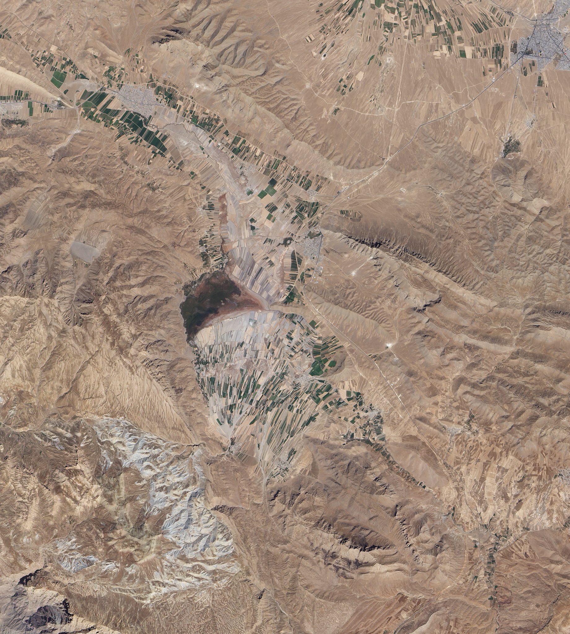
English: Natural-colour image of an area south of Esfahan, including the town of Gandoman. Northwest and south of the city, irrigated fields make elongated rectangles of green, interspersed with earth-toned fallow fields. Crop-lands and settlements are mostly confined to flat areas.
Surrounding the farmed areas are rugged hills and valleys, mostly devoid of vegetation. East north-east of Gandoman, a long ridge casts shadows to the north. It is one of several such ridges visible in this image, and east of the town, the ridges primarily run parallel to each other. In the west, ridge-lines appear more random, extending in multiple directions. Here in the foothills of the Zagros Mountains, elevations are roughly comparable to those of Denver, Colorado, at the base of the foothills of the Rocky Mountains. Near the centre of the image, what might look like a semicircular ridge casting a long, uneven shadow is actually a combination of flat, farmed land bordered on the north by an expanse of natural vegetation. Although water is scarce in this part of Iran, small lakes and wetlands occur sporadically throughout the region. |
| ڕێکەوت | |
| سەرچاوە | NASA Earth Observatory |
| بەرھەمھێنەر | Jesse Allen and Robert Simmon |
Image captured by the Advanced Land Imager (ALI) on NASA’s Earth Observing-1 (EO-1) satellite.
مۆڵەتنامە
| This file is in the public domain in the United States because it was solely created by NASA. NASA copyright policy states that "NASA material is not protected by copyright unless noted". (See Template:PD-USGov, NASA copyright policy page or JPL Image Use Policy.) | ||
 |
Warnings:
|
| Annotations | This image is annotated: View the annotations at Commons |
مێژووی پەڕگە
کرتە بکە لەسەر یەکێک لە ڕێکەوت/کاتەکان بۆ بینینی پەڕگەکە بەو شێوەی لەو کاتەدا بووە.
| ڕێکەوت/کات | ھێما | ئەندازە | بەکارھێنەر | تێبینی | |
|---|---|---|---|---|---|
| هەنووکە | ١١:٠٢، ١ی تشرینی دووەمی ٢٠١٠ | | ٣٬١٤٦ لە ٣٬٥٠٠ (٤٫٤٧ مێگابایت) | Originalwana | {{Information |Description={{en|1=Natural-colour image of an area south of Esfahan, including the town of Gandoman. Northwest and south of the city, irrigated fields make elongated rectangles of green, interspersed with earth-toned [[:Category:Fal |
بەکارھێنانی پەڕگە
ئەم پەڕەیە ئەم پەڕگەیە بەکار دەھێنێت:
بەکارھێنانی سەرانسەریی پەڕگە
ئەم ویکیانەی دیکەی خوارەوەش ئەم پەڕگە بەکاردێنن:
- بەکارھێنان لە ar.wikipedia.org
- بەکارھێنان لە az.wikipedia.org
- بەکارھێنان لە ceb.wikipedia.org
- بەکارھێنان لە en.wikipedia.org
- بەکارھێنان لە fa.wikipedia.org
- بەکارھێنان لە it.wikipedia.org
- بەکارھێنان لە mg.wikipedia.org
- بەکارھێنان لە ru.wikipedia.org
- بەکارھێنان لە tr.wikipedia.org
- بەکارھێنان لە ur.wikipedia.org
- بەکارھێنان لە uz.wikipedia.org
- بەکارھێنان لە www.wikidata.org
- بەکارھێنان لە zh.wikipedia.org