
پەڕگە:Former Yugoslavia Map.png
پەڕگەی سەرەکی (٣٬٢٨٠ × ٢٬٣٩٨ پیکسڵ، قەبارەی پەڕگە: ٢٫٥٥ مێگابایت، جۆری ئێم ئای ئێم ئی: image/png)
Kosovo is Serbia
I saw michel morpisdkjnfalsdkjvcasd.Ken.
کورتە
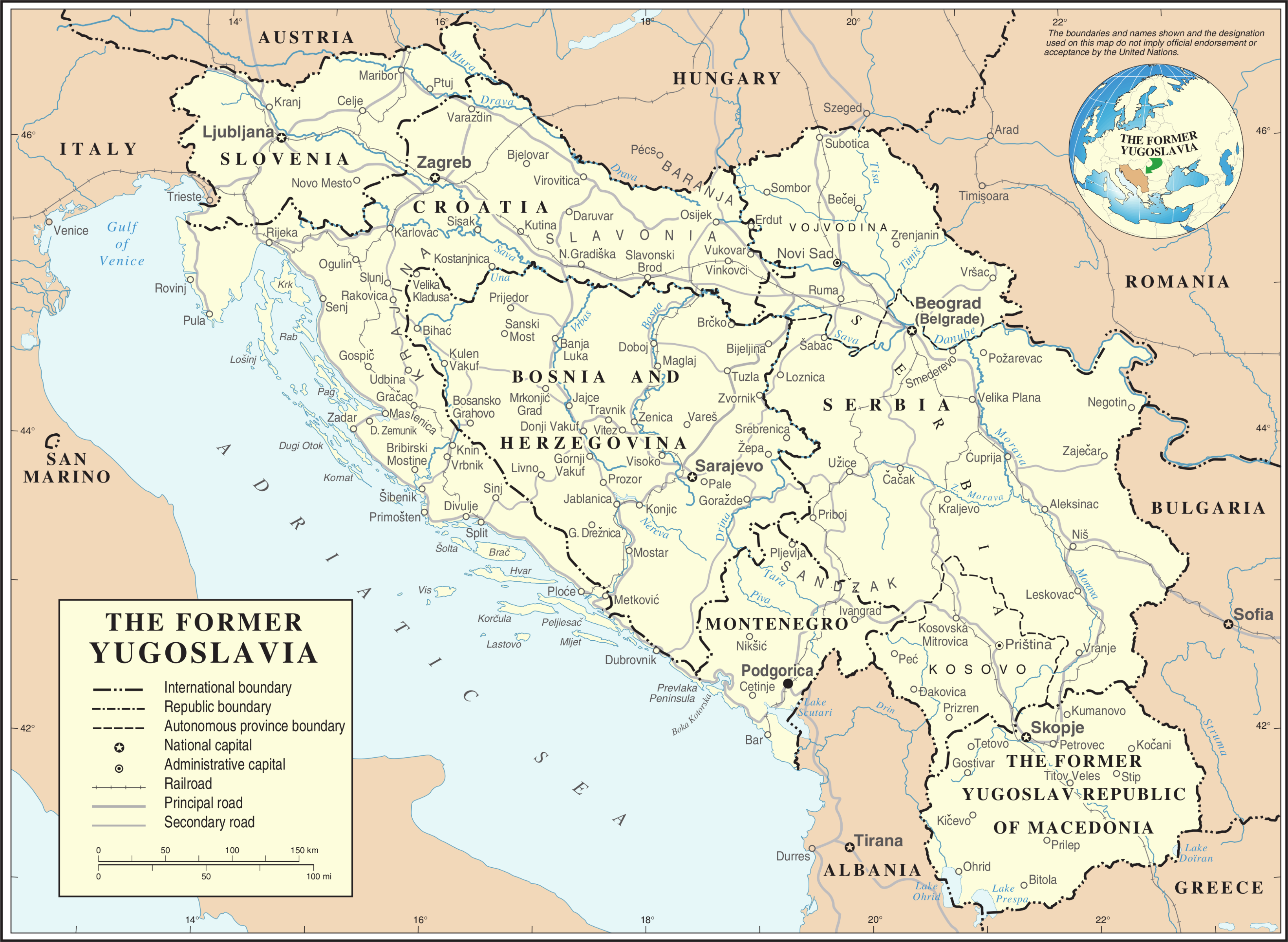
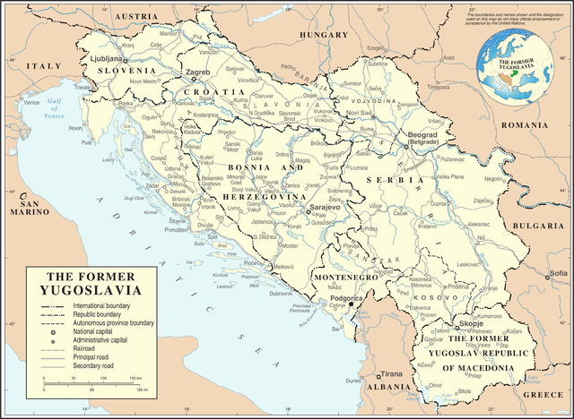
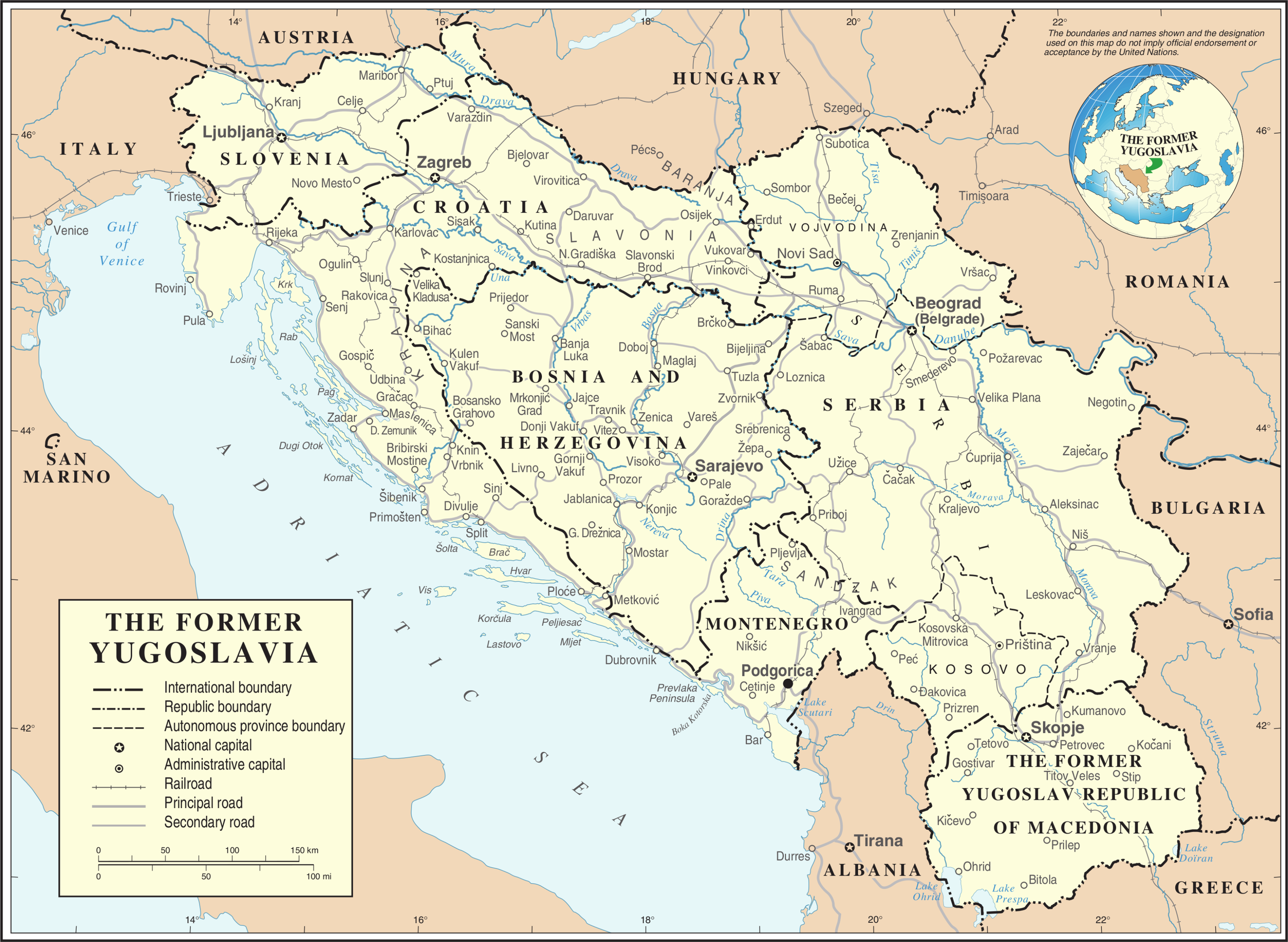
| وەسف | Map of former Yugoslavia. | |||
| ڕێکەوت | ||||
| سەرچاوە | The Cartographic Section of the United Nations (CSUN) | |||
| بەرھەمھێنەر | Cartographer of the United Nations | |||
| ڕێپێدان (بەکارھێنانەوەی ئەم پەڕگەیە) |
|
|||
| وەشانەکانی تر |
|


مێژووی پەڕگە
کرتە بکە لەسەر یەکێک لە ڕێکەوت/کاتەکان بۆ بینینی پەڕگەکە بەو شێوەی لەو کاتەدا بووە.
| ڕێکەوت/کات | ھێما | ئەندازە | بەکارھێنەر | تێبینی | |
|---|---|---|---|---|---|
| هەنووکە | ٢٠:٣٩، ٢١ی تشرینی یەکەمی ٢٠٠٧ | | ٣٬٢٨٠ لە ٢٬٣٩٨ (٢٫٥٥ مێگابایت) | Jeroen | Recreated an updated map from the same source, but now incl. Montenegro and Serbia as independent nations. |
| ١٧:٠٢، ١٠ی ئازاری ٢٠٠٧ |  | ٣٬٢٣١ لە ٢٬٣٦٧ (١٫٦ مێگابایت) | Minestrone | Former Yugoslavia Map {{Information |Description=Former Yugoslavia Map |Source=The Cartographic Section of the United Nations (CSUN) |Date=2007-03-10 |Author=Cartographer of the United Nations |Permission={{Template:UN map}} and the cartographer of |
بەکارھێنانی پەڕگە
ئەم پەڕەی 4ە ئەم پەڕگەیە بەکار دەھێنێت:
بەکارھێنانی سەرانسەریی پەڕگە
ئەم ویکیانەی دیکەی خوارەوەش ئەم پەڕگە بەکاردێنن:
- بەکارھێنان لە ar.wikipedia.org
- بەکارھێنان لە az.wikipedia.org
- بەکارھێنان لە bs.wikipedia.org
- بەکارھێنان لە ca.wikipedia.org
- بەکارھێنان لە cs.wikipedia.org
- بەکارھێنان لە de.wikipedia.org
- بەکارھێنان لە el.wiktionary.org
- بەکارھێنان لە en.wikipedia.org
- بەکارھێنان لە es.wikipedia.org
- بەکارھێنان لە fa.wikipedia.org
- بەکارھێنان لە fr.wikipedia.org
- بەکارھێنان لە fr.wiktionary.org
- بەکارھێنان لە id.wikipedia.org
- بەکارھێنان لە ja.wikipedia.org
- بەکارھێنان لە ka.wikipedia.org
- بەکارھێنان لە ko.wikipedia.org
- بەکارھێنان لە lb.wikipedia.org
- بەکارھێنان لە mzn.wikipedia.org
- بەکارھێنان لە nl.wikipedia.org
بینینی بەکارھێنانی گشتی زیاتری ئەم پەڕگەیە.