
پەڕگە:Europe 912 en.jpg

قەبارەی ئەم پێشبینینە: ٥٨٤ لە ٥٩٩ پیکسەڵ. ڕێزەلووشنەکانی تر: ٢٣٤ لە ٢٤٠ پیکسەڵ | ٤٦٨ لە ٤٨٠ پیکسەڵ | ٧٤٨ لە ٧٦٨ پیکسەڵ | ١٬٢٠٦ لە ١٬٢٣٨ پیکسەڵ.
پەڕگەی سەرەکی (١٬٢٠٦ × ١٬٢٣٨ پیکسڵ، قەبارەی پەڕگە: ٥٢٩ کیلۆبایت، جۆری ئێم ئای ئێم ئی: image/jpeg)
_en.png)
.png)
.jpg)
کورتە
| وەسف |
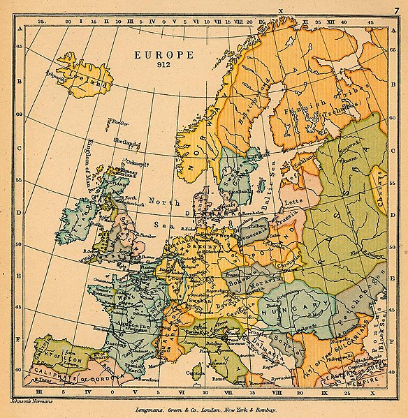
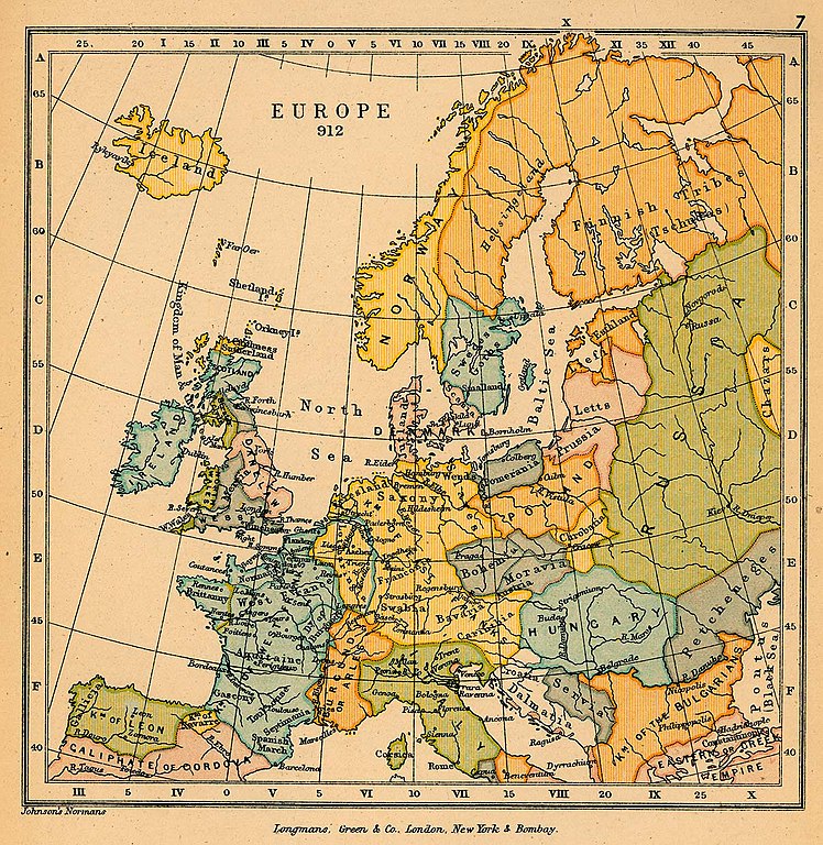
English: A political map of most of Europe in 912 CE |
| ڕێکەوت | |
| سەرچاوە | The map is taken from "The Public Schools Historical Atlas" by Charles Colbeck. Longmans, Green; New York; London; Bombay. 1905. It was accessed through the University of Texas at Austin's Perry-Castañeda Library Map Collection. |
| بەرھەمھێنەر | Charles Colbeck |
مۆڵەتنامە
This work is in the public domain in the United States because it was published (or registered with the U.S. Copyright Office) before January 1, 1929.
Public domain works must be out of copyright in both the United States and in the source country of the work in order to be hosted on the Commons. If the work is not a U.S. work, the file must have an additional copyright tag indicating the copyright status in the source country.
Note: This tag should not be used for sound recordings. |
مێژووی پەڕگە
کرتە بکە لەسەر یەکێک لە ڕێکەوت/کاتەکان بۆ بینینی پەڕگەکە بەو شێوەی لەو کاتەدا بووە.
| ڕێکەوت/کات | ھێما | ئەندازە | بەکارھێنەر | تێبینی | |
|---|---|---|---|---|---|
| هەنووکە | ١٨:٢٨، ١١ی کانوونی دووەمی ٢٠١٩ | | ١٬٢٠٦ لە ١٬٢٣٨ (٥٢٩ کیلۆبایت) | Bryanrutherford0 | User created page with UploadWizard |
بەکارھێنانی پەڕگە
ھیچ پەڕەیەک نییە کە ئەم پەڕگەیە بەکاربھێنێت.
بەکارھێنانی سەرانسەریی پەڕگە
ئەم ویکیانەی دیکەی خوارەوەش ئەم پەڕگە بەکاردێنن:
- بەکارھێنان لە en.wikipedia.org
- بەکارھێنان لە no.wikipedia.org