
پەڕگە:Aegean 6 nm.svg

Size of this PNG preview of this SVG file: ٤٣٢ لە ٤٦٧ پیکسەڵ. ڕێزەلووشنەکانی تر: ٢٢٢ لە ٢٤٠ پیکسەڵ | ٤٤٤ لە ٤٨٠ پیکسەڵ | ٧١٠ لە ٧٦٨ پیکسەڵ | ٩٤٧ لە ١٬٠٢٤ پیکسەڵ | ١٬٨٩٤ لە ٢٬٠٤٨ پیکسەڵ.
پەڕگەی سەرەکی (پەڕگەی SVG، بە ناو ٤٣٢ × ٤٦٧ پیکسەڵ، قەبارەی پەڕگە: ٢١٩ کیلۆبایت)
کورتە
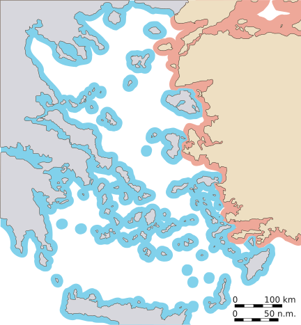
| وەسف | Map of the Aegean, with approximate extent of current 6nm territorial waters. To be used as illustration in en:Aegean dispute. |
| ڕێکەوت | |
| سەرچاوە | بەرھەمی خۆم |
| بەرھەمھێنەر | w:en:User:Future Perfect at Sunrise |
مۆڵەتنامە
من، ھەڵگری مافی لەبەرگرتنەوەی ئەم بەرھەمە، لەژێر ئەم مۆڵەتنامەیانەدا بڵاوی دەکەمەوە:

|
ڕێگەدراوە بە لەبەرگرتنەوە، دابەشکردن ھەروەھا/یان سازاندنی ئەم بەڵگەنامەیە لەژێر مەرجی مۆڵەتی GNU بۆ بەڵگەنامەی ئازاد، وەشانی ١.٢ یان ھەر وەشانێکی تری دواتر کە بڵاوکراوەتەوە لەلایەن دامەزراوەی بەرنامەی ئازاد، بەبێ ھیچ بەشێکی جیاواز، بەبێ نووسین لەسەر بەرگی پێشەوە و دواوەی. وێنەیەک لەمۆڵەتەکە لە بەشێکدا ھەیە کە ناوی مۆڵەتی GNU بۆ بەڵگەنامەی ئازادە. |
| ئەم پەڕگەیە لە ژێر مۆڵەتنامەی | ||
| ||
| This licensing tag was added to this file as part of the GFDL licensing update. |
This file is licensed under the Creative Commons Attribution-Share Alike 2.5 Generic, 2.0 Generic and 1.0 Generic license.
- تۆ ئازادی:
- بۆ بڵاکردنەوە – بۆ کۆپی کردن، دابەشکردن و دەستبەدەست ناردنی
- بۆ تێکەڵکردنەوە – بۆ سازاندنی کارەکە
- بەم مەرجانەی خوارەوە:
- دانەپاڵ – پێویستە باوەڕی گونجاو بدەیت، بەستەرێک بۆ مۆڵەتەکە دابین بکەیت و ئاماژە بەوە بکەیت کە ئایا گۆڕانکاری کراوە یان نا. دەتوانیت بە هەر شێوەیەکی گونجاو ئەوە بکەیت، بەڵام بە شێوەیەک نا کە وا دەربکەوێت کە مۆڵەتدەر پشتگیری تۆ یان بەکارهێنانەکەت بکات.
- بڵاوکردنەوەی گونجاو – ئەگەر لەسەر بنەمای ئەم کارە تێکەڵ، گۆڕان، یان ساز بکەی، پێویستە بەشدارییەکانت بە هەمان مۆڵەت یان هاوشێوەی مۆڵەتی ئەسڵی دابەش بکەی.
دەتوانی مۆڵەتنامەی دڵخوازت ھەڵبژێریت.
مێژووی پەڕگە
کرتە بکە لەسەر یەکێک لە ڕێکەوت/کاتەکان بۆ بینینی پەڕگەکە بەو شێوەی لەو کاتەدا بووە.
| ڕێکەوت/کات | ھێما | ئەندازە | بەکارھێنەر | تێبینی | |
|---|---|---|---|---|---|
| هەنووکە | ٢٣:٠٠، ٣٠ی کانوونی دووەمی ٢٠٠٧ | | ٤٣٢ لە ٤٦٧ (٢١٩ کیلۆبایت) | Future Perfect at Sunrise | |
| ٢٢:٥٥، ٣٠ی کانوونی دووەمی ٢٠٠٧ |  | ٤٣٢ لە ٤٦٧ (٢١٩ کیلۆبایت) | Future Perfect at Sunrise | ||
| ٢٢:٠٩، ٢٨ی کانوونی دووەمی ٢٠٠٧ |  | ٤٣٥ لە ٤٧٠ (٢٢٠ کیلۆبایت) | Future Perfect at Sunrise | ||
| ٠٠:٢٤، ٢٨ی کانوونی دووەمی ٢٠٠٧ |  | ٥٧٦ لە ٦١٢ (٢١٩ کیلۆبایت) | Future Perfect at Sunrise | {{Information |Description=Map of the Aegean, with approximate extent of current 6nm territorial waters. To be used as illustration in w:en:Aegean dispute. |Source=Own work |Date=27 Jan 2007 |Author=w:en:User:Future Perfect at Sunrise |Permission |
بەکارھێنانی پەڕگە
ئەم پەڕەیە ئەم پەڕگەیە بەکار دەھێنێت:
بەکارھێنانی سەرانسەریی پەڕگە
ئەم ویکیانەی دیکەی خوارەوەش ئەم پەڕگە بەکاردێنن:
- بەکارھێنان لە ar.wikipedia.org
- بەکارھێنان لە ca.wikipedia.org
- بەکارھێنان لە de.wikipedia.org
- بەکارھێنان لە el.wikipedia.org
- بەکارھێنان لە en.wikipedia.org
- بەکارھێنان لە es.wikipedia.org
- بەکارھێنان لە fa.wikipedia.org
- بەکارھێنان لە fr.wikipedia.org
- بەکارھێنان لە hy.wikipedia.org
- بەکارھێنان لە id.wikipedia.org
- بەکارھێنان لە jv.wikipedia.org
- بەکارھێنان لە ka.wikipedia.org
- بەکارھێنان لە mzn.wikipedia.org
- بەکارھێنان لە pt.wikipedia.org
- بەکارھێنان لە ru.wikipedia.org
- بەکارھێنان لە tg.wikipedia.org
- بەکارھێنان لە tr.wikipedia.org
- بەکارھێنان لە uk.wikipedia.org
- بەکارھێنان لە www.wikidata.org