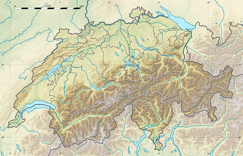
پەڕگە:Switzerland relief location map.jpg
ڕواڵەت

قەبارەی ئەم پێشبینینە: ٨٠٠ لە ٥١٣ پیکسەڵ. ڕێزەلووشنەکانی تر: ٣٢٠ لە ٢٠٥ پیکسەڵ | ٦٤٠ لە ٤١٠ پیکسەڵ | ١٬٠٢٤ لە ٦٥٧ پیکسەڵ | ١٬٣٤٩ لە ٨٦٥ پیکسەڵ.
پەڕگەی سەرەکی (١٬٣٤٩ × ٨٦٥ پیکسڵ، قەبارەی پەڕگە: ٦٠٢ کیلۆبایت، جۆری ئێم ئای ئێم ئی: image/jpeg)
مێژووی پەڕگە
کرتە بکە لەسەر یەکێک لە ڕێکەوت/کاتەکان بۆ بینینی پەڕگەکە بەو شێوەی لەو کاتەدا بووە.
| ڕێکەوت/کات | ھێما | ئەندازە | بەکارھێنەر | تێبینی | |
|---|---|---|---|---|---|
| هەنووکە | ٢١:٠٤، ١٧ی کانوونی یەکەمی ٢٠١٧ |  | ١٬٣٤٩ لە ٨٦٥ (٦٠٢ کیلۆبایت) | Reinhard Kraasch | Verlauf des Doubs korrigiert / Doubs River course retouched |
| ١٣:٢٨، ١٩ی تەممووزی ٢٠١٠ |  | ١٬٣٤٩ لە ٨٦٥ (٤٣٩ کیلۆبایت) | Sting | Color profile | |
| ١٤:٢٧، ٤ی کانوونی یەکەمی ٢٠٠٩ |  | ١٬٣٤٩ لە ٨٦٥ (٤٥٦ کیلۆبایت) | Sting | == {{int:filedesc}} == {{Location|46|49|30|N|8|15|00|E|scale:1000000}} <br/> {{Information |Description={{de|Relief Positionskarte der Schweiz.}} {{en|Blank physical map of Switzerland, for geo-location purpose.}} {{fr| |
بەکارھێنانی پەڕگە
ئەم پەڕەی 6ە ئەم پەڕگەیە بەکار دەھێنێت:
بەکارھێنانی سەرانسەریی پەڕگە
ئەم ویکیانەی دیکەی خوارەوەش ئەم پەڕگە بەکاردێنن:
- بەکارھێنان لە als.wikipedia.org
- Langensee
- Gotthardpass
- Rheinwaldhorn
- Pfäffikersee
- Sarnersee
- Etzel (Berg)
- Höhronen (Berg)
- Sattel (Pass)
- Churfirsten
- Säntis
- Wohlensee
- Ruine Rifenstein
- Wartenberg (Muttenz)
- Lägern
- Schloss Lenzburg
- Uetliberg
- Schloss Chillon
- Schloss Bottmingen
- Schloss Pratteln
- Ruine Madeln
- Burg Kropfenstein
- Vorlage:Positionskarte Schweiz
- Schloss Klingnau
- Ruine Iberg
- Ruine Besserstein
- Rengg
- Schloss Rümligen
- Pilatus
- Festung Aarburg
- Dufourspitze
- Schloss Schwarzwasserstelz
- Schloss Stein
- Schloss Uster
- Stausee Wettingen
- Grosser St. Bernhard
- Malojapass
- Splügenpass
- Matterhorn
- Schwendisee
- Morgenberghorn
- Ruine Schenkenberg
- Schloss Auenstein
- Schloss Kasteln
- Siggenberg
- Chestenberg
- Bruggerberg
- Wartenberg-Ruinen
- Scheidegg (Tecknau)
- Ruine Münchenstein
- Ruine Farnsburg
بینینی بەکارھێنانی گشتی زیاتری ئەم پەڕگەیە.


