
پەڕگە:Sediment in the Gulf of Mexico.jpg
قەبارەی ئەم پێشبینینە: ٦٥٧ لە ٥٩٩ پیکسەڵ. ڕێزەلووشنەکانی تر: ٢٦٣ لە ٢٤٠ پیکسەڵ | ٥٢٦ لە ٤٨٠ پیکسەڵ | ٨٤٢ لە ٧٦٨ پیکسەڵ | ١٬١٢٣ لە ١٬٠٢٤ پیکسەڵ | ٢٬٢٤٦ لە ٢٬٠٤٨ پیکسەڵ | ٤٬٨٠٤ لە ٤٬٣٨١ پیکسەڵ.
پەڕگەی سەرەکی (٤٬٨٠٤ × ٤٬٣٨١ پیکسڵ، قەبارەی پەڕگە: ٦٫١١ مێگابایت، جۆری ئێم ئای ئێم ئی: image/jpeg)
کورتە
| وەسف |
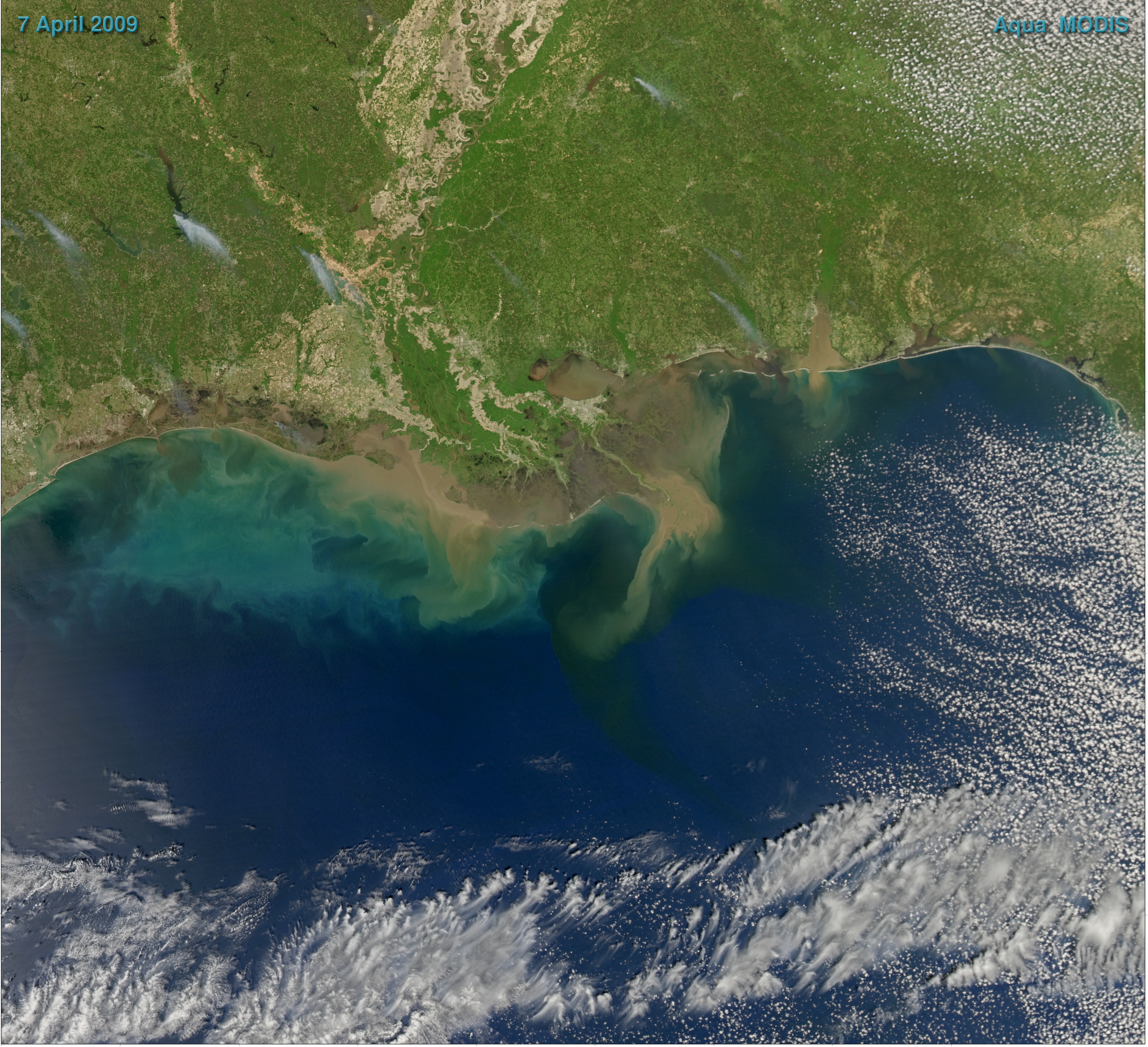
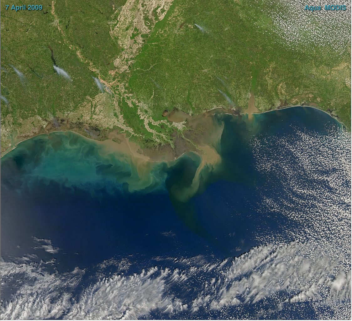
English: Sediment-laden water pours into the northern Gulf of Mexico from the Atchafalaya River in this photo-like image, taken by the Moderate Resolution Imaging Spectroradiometer (MODIS) on NASA’s Aqua satellite. The springtime river plume is distinct in the sediment-laden coastal water, turning the water the color of land. The tan gradually fades to clouds of green and blue as the sediment disperses. |
| ڕێکەوت | |
| سەرچاوە | NASA Earth Observatory |
| بەرھەمھێنەر | Norman Kuring |
| وەشانەکانی تر |
|
.jpg)
NASA image courtesy Norman Kuring, Ocean Color Team.
مۆڵەتنامە
| This file is in the public domain in the United States because it was solely created by NASA. NASA copyright policy states that "NASA material is not protected by copyright unless noted". (See Template:PD-USGov, NASA copyright policy page or JPL Image Use Policy.) | ||
 |
Warnings:
|
مێژووی پەڕگە
کرتە بکە لەسەر یەکێک لە ڕێکەوت/کاتەکان بۆ بینینی پەڕگەکە بەو شێوەی لەو کاتەدا بووە.
| ڕێکەوت/کات | ھێما | ئەندازە | بەکارھێنەر | تێبینی | |
|---|---|---|---|---|---|
| هەنووکە | ٠٨:٥٥، ٢٩ی ئەیلوولی ٢٠٠٩ | | ٤٬٨٠٤ لە ٤٬٣٨١ (٦٫١١ مێگابایت) | Cropbot | upload cropped version, operated by User:Originalwana. Summary: cropped |
| ١٦:١٠، ١٩ی نیسانی ٢٠٠٩ |  | ٥٬٠٨٧ لە ٤٬٦٧٢ (٦٫٣٢ مێگابایت) | Originalwana | {{Information |Description={{en|1=Sediment-laden water pours into the northern Gulf of Mexico from the Atchafalaya River in this photo-like image, taken by the Moderate Resolution Imaging Spectroradiometer (MODIS) on NASA’s Aqua satellite. The springtim |
بەکارھێنانی پەڕگە
ئەم پەڕەیە ئەم پەڕگەیە بەکار دەھێنێت:
بەکارھێنانی سەرانسەریی پەڕگە
ئەم ویکیانەی دیکەی خوارەوەش ئەم پەڕگە بەکاردێنن:
- بەکارھێنان لە ar.wikipedia.org
- بەکارھێنان لە en.wikipedia.org
- بەکارھێنان لە fr.wikipedia.org
- بەکارھێنان لە hi.wikipedia.org
- بەکارھێنان لە hy.wikipedia.org
- بەکارھێنان لە incubator.wikimedia.org
- بەکارھێنان لە sr.wikipedia.org
- بەکارھێنان لە tl.wikipedia.org
- بەکارھێنان لە uk.wikipedia.org
- بەکارھێنان لە vi.wikipedia.org