
پەڕگە:Santa Monica Bay Map.jpg
رەزۆلوشنی سەرتر لەمە لە بەردەست دا نیە.
Santa_Monica_Bay_Map.jpg (٤٦٨ × ٥٩٧ پیکسڵ، قەبارەی پەڕگە: ٢٨٣ کیلۆبایت، جۆری ئێم ئای ئێم ئی: image/jpeg)
کورتە
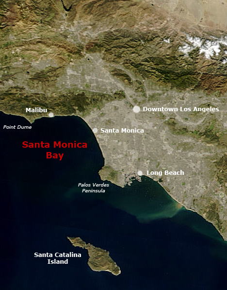
English: Satellite pictures of Southern California with Santa Monica Bay and Greater Los Angeles.
- Following the original text out of the English wikipedia, where it was originally uploaded:
- Map of Southern California with Santa Monica Bay identified
- Underlying map is an aerial map obtained from NASA (original:
- The labeling is by en:User:Mikeetc
مۆڵەتنامە
| This file is in the public domain in the United States because it was solely created by NASA. NASA copyright policy states that "NASA material is not protected by copyright unless noted". (See Template:PD-USGov, NASA copyright policy page or JPL Image Use Policy.) | ||
 |
Warnings:
|
مێژووی پەڕگە
کرتە بکە لەسەر یەکێک لە ڕێکەوت/کاتەکان بۆ بینینی پەڕگەکە بەو شێوەی لەو کاتەدا بووە.
| ڕێکەوت/کات | ھێما | ئەندازە | بەکارھێنەر | تێبینی | |
|---|---|---|---|---|---|
| هەنووکە | ٢٣:٥٥، ٢٨ی ئایاری ٢٠٠٦ | | ٤٦٨ لە ٥٩٧ (٢٨٣ کیلۆبایت) | Otto Normalverbraucher | following the original text out of the english wikipedia, where it was originally uploaded: ''Map of Southern California with Santa Monica Bay identified Underlying map is an aerial map obtained from NASA (original: http://earthobservatory.nasa.gov/Natu |
بەکارھێنانی پەڕگە
ئەم پەڕەیە ئەم پەڕگەیە بەکار دەھێنێت:
بەکارھێنانی سەرانسەریی پەڕگە
ئەم ویکیانەی دیکەی خوارەوەش ئەم پەڕگە بەکاردێنن:
- بەکارھێنان لە ar.wikipedia.org
- بەکارھێنان لە ceb.wikipedia.org
- بەکارھێنان لە de.wikipedia.org
- بەکارھێنان لە en.wikipedia.org
- بەکارھێنان لە es.wikipedia.org
- بەکارھێنان لە fr.wikipedia.org
- بەکارھێنان لە fr.wikibooks.org
- بەکارھێنان لە he.wikipedia.org
- بەکارھێنان لە pl.wikipedia.org
- بەکارھێنان لە pt.wikipedia.org
- بەکارھێنان لە ro.wikipedia.org
- بەکارھێنان لە ru.wikipedia.org
- بەکارھێنان لە www.wikidata.org