پەڕگە:Population density.png

قەبارەی ئەم پێشبینینە: ٨٠٠ لە ٤٠٠ پیکسەڵ. ڕێزەلووشنەکانی تر: ٣٢٠ لە ١٦٠ پیکسەڵ | ٦٤٠ لە ٣٢٠ پیکسەڵ | ١٬٠٢٤ لە ٥١٢ پیکسەڵ | ١٬٢٨٠ لە ٦٤٠ پیکسەڵ | ٢٬٥٦٠ لە ١٬٢٨٠ پیکسەڵ | ٤٬٣٢٠ لە ٢٬١٦٠ پیکسەڵ.
پەڕگەی سەرەکی (٤٬٣٢٠ × ٢٬١٦٠ پیکسڵ، قەبارەی پەڕگە: ٥٢٢ کیلۆبایت، جۆری ئێم ئای ئێم ئی: image/png)
مێژووی پەڕگە
کرتە بکە لەسەر یەکێک لە ڕێکەوت/کاتەکان بۆ بینینی پەڕگەکە بەو شێوەی لەو کاتەدا بووە.
| ڕێکەوت/کات | ھێما | ئەندازە | بەکارھێنەر | تێبینی | |
|---|---|---|---|---|---|
| هەنووکە | ٠٠:٤١، ١١ی نیسانی ٢٠١٣ |  | ٤٬٣٢٠ لە ٢٬١٦٠ (٥٢٢ کیلۆبایت) | Jahoe | Re-downloaded original from http://eoimages.gsfc.nasa.gov/images/imagerecords/53000/53005/population_density.tif, re-converted to PNG (preserving alpha channel) using tiff2png (by Willem van Schaik and Greg Roelofs). Removed rgb pixel values from fully... |
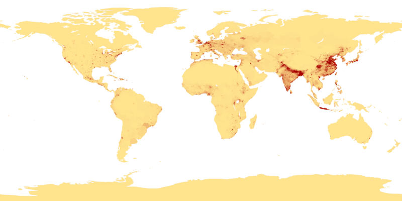
| ٠٣:٤١، ٢٧ی شوباتی ٢٠٠٧ |  | ٤٬٣٢٠ لە ٢٬١٦٠ (٩١٥ کیلۆبایت) | Keenan Pepper | This image shows the number of people per square kilometer around the world in 1994. The data were derived from population records based on political divisions such as states, provinces, and counties. The image was taken from [http://visibleearth.nasa.go |
بەکارھێنانی پەڕگە
ئەم پەڕەی 2ە ئەم پەڕگەیە بەکار دەھێنێت:
بەکارھێنانی سەرانسەریی پەڕگە
ئەم ویکیانەی دیکەی خوارەوەش ئەم پەڕگە بەکاردێنن:
- بەکارھێنان لە als.wikipedia.org
- بەکارھێنان لە an.wikipedia.org
- بەکارھێنان لە ar.wikipedia.org
- بەکارھێنان لە ast.wikipedia.org
- بەکارھێنان لە az.wikipedia.org
- بەکارھێنان لە be-tarask.wikipedia.org
- بەکارھێنان لە be.wikipedia.org
- بەکارھێنان لە bg.wikipedia.org
- بەکارھێنان لە bh.wikipedia.org
- بەکارھێنان لە bn.wikipedia.org
- بەکارھێنان لە bs.wikipedia.org
- بەکارھێنان لە ca.wikipedia.org
- بەکارھێنان لە ce.wikipedia.org
- بەکارھێنان لە cu.wikipedia.org
- بەکارھێنان لە cv.wikipedia.org
- بەکارھێنان لە da.wikipedia.org
- بەکارھێنان لە da.wikibooks.org
- بەکارھێنان لە de.wikipedia.org
- بەکارھێنان لە dsb.wikipedia.org
- بەکارھێنان لە el.wikipedia.org
- بەکارھێنان لە en.wikipedia.org
- بەکارھێنان لە en.wikiquote.org
- بەکارھێنان لە eo.wikipedia.org
- بەکارھێنان لە es.wikipedia.org
بینینی بەکارھێنانی گشتی زیاتری ئەم پەڕگەیە.


