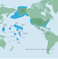
پەڕگە:NOAA Map of the US EEZ.svg
ڕواڵەت

Size of this PNG preview of this SVG file: ٥٩٩ لە ٦٠٠ پیکسەڵ. ڕێزەلووشنەکانی تر: ٢٤٠ لە ٢٤٠ پیکسەڵ | ٤٧٩ لە ٤٨٠ پیکسەڵ | ٧٦٧ لە ٧٦٨ پیکسەڵ | ١٬٠٢٢ لە ١٬٠٢٤ پیکسەڵ | ٢٬٠٤٥ لە ٢٬٠٤٨ پیکسەڵ | ٦١٢ لە ٦١٣ پیکسەڵ.
پەڕگەی سەرەکی (پەڕگەی SVG، بە ناو ٦١٢ × ٦١٣ پیکسەڵ، قەبارەی پەڕگە: ١٫٩٣ مێگابایت)
مێژووی پەڕگە
کرتە بکە لەسەر یەکێک لە ڕێکەوت/کاتەکان بۆ بینینی پەڕگەکە بەو شێوەی لەو کاتەدا بووە.
| ڕێکەوت/کات | ھێما | ئەندازە | بەکارھێنەر | تێبینی | |
|---|---|---|---|---|---|
| هەنووکە | ٠٢:٤٥، ٣ی ئایاری ٢٠٢٢ |  | ٦١٢ لە ٦١٣ (١٫٩٣ مێگابایت) | NuclearElevator | Re-converted the PDF to SVG using Inkscape's "Popplar/Cairo Import" instead of its "Internal Import" to fix text rendering issue on Wikimedia's PNG versions of the file |
| ٠٢:٣٦، ٣ی ئایاری ٢٠٢٢ |  | ٨١٦ لە ٨١٧ (١٫٢ مێگابایت) | NuclearElevator | Uploaded a work by National Oceanic and Atmospheric Administration from http://www.gc.noaa.gov/documents/2011/012711_gcil_maritime_eez_map.pdf with UploadWizard |
بەکارھێنانی پەڕگە
ئەم پەڕەیە ئەم پەڕگەیە بەکار دەھێنێت:
بەکارھێنانی سەرانسەریی پەڕگە
ئەم ویکیانەی دیکەی خوارەوەش ئەم پەڕگە بەکاردێنن:
- بەکارھێنان لە bn.wikipedia.org
- بەکارھێنان لە dtp.wikipedia.org
- بەکارھێنان لە en.wikipedia.org
- بەکارھێنان لە fa.wikipedia.org
- بەکارھێنان لە he.wikipedia.org
- بەکارھێنان لە iba.wikipedia.org
- بەکارھێنان لە id.wikipedia.org
- بەکارھێنان لە incubator.wikimedia.org
- بەکارھێنان لە ko.wikipedia.org
- بەکارھێنان لە pa.wikipedia.org
- بەکارھێنان لە so.wikipedia.org
- بەکارھێنان لە th.wikipedia.org
- بەکارھێنان لە tum.wikipedia.org

