
پەڕگە:NCyprus districts named.png

رەزۆلوشنی سەرتر لەمە لە بەردەست دا نیە.
NCyprus_districts_named.png (٦٠٠ × ٣٦٥ پیکسڵ، قەبارەی پەڕگە: ٤٧ کیلۆبایت، جۆری ئێم ئای ئێم ئی: image/png)
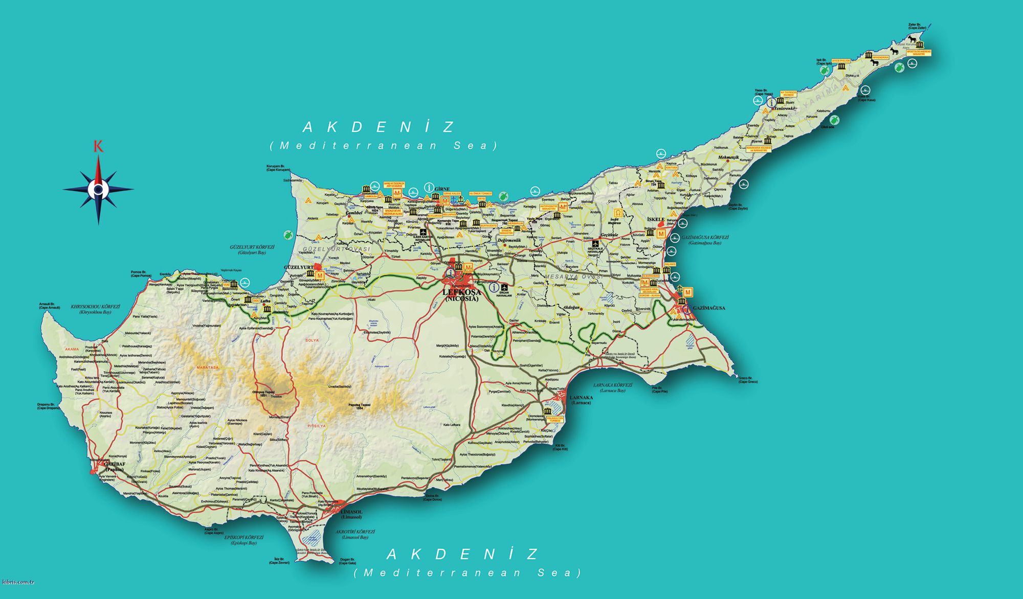
| وەسف | Map of the districts of Cyprus, with English annotations, and showing the Turkish Republic of Northern Cyprus, United Kingdom Sovereign Base Areas, and United Nations buffer zone. The TRNC section illustrates the current de facto district boundaries following this map as a guide. The northern districts are labelled in Turkish. | |||
| ڕێکەوت | (UTC) | |||
| سەرچاوە | ||||
| بەرھەمھێنەر |
|
|||
| وەشانەکانی تر |
|


من، ھەڵگری مافی لەبەرگرتنەوەی ئەم بەرھەمە، لەژێر ئەم مۆڵەتنامەیانەدا بڵاوی دەکەمەوە:
This file is licensed under the Creative Commons Attribution-Share Alike 2.5 Generic, 2.0 Generic and 1.0 Generic license.
- تۆ ئازادی:
- بۆ بڵاکردنەوە – بۆ کۆپی کردن، دابەشکردن و دەستبەدەست ناردنی
- بۆ تێکەڵکردنەوە – بۆ سازاندنی کارەکە
- بەم مەرجانەی خوارەوە:
- دانەپاڵ – پێویستە باوەڕی گونجاو بدەیت، بەستەرێک بۆ مۆڵەتەکە دابین بکەیت و ئاماژە بەوە بکەیت کە ئایا گۆڕانکاری کراوە یان نا. دەتوانیت بە هەر شێوەیەکی گونجاو ئەوە بکەیت، بەڵام بە شێوەیەک نا کە وا دەربکەوێت کە مۆڵەتدەر پشتگیری تۆ یان بەکارهێنانەکەت بکات.
- بڵاوکردنەوەی گونجاو – ئەگەر لەسەر بنەمای ئەم کارە تێکەڵ، گۆڕان، یان ساز بکەی، پێویستە بەشدارییەکانت بە هەمان مۆڵەت یان هاوشێوەی مۆڵەتی ئەسڵی دابەش بکەی.

|
ڕێگەدراوە بە لەبەرگرتنەوە، دابەشکردن ھەروەھا/یان سازاندنی ئەم بەڵگەنامەیە لەژێر مەرجی مۆڵەتی GNU بۆ بەڵگەنامەی ئازاد، وەشانی ١.٢ یان ھەر وەشانێکی تری دواتر کە بڵاوکراوەتەوە لەلایەن دامەزراوەی بەرنامەی ئازاد، بەبێ ھیچ بەشێکی جیاواز، بەبێ نووسین لەسەر بەرگی پێشەوە و دواوەی. وێنەیەک لەمۆڵەتەکە لە بەشێکدا ھەیە کە ناوی مۆڵەتی GNU بۆ بەڵگەنامەی ئازادە. |
| ئەم پەڕگەیە لە ژێر مۆڵەتنامەی | ||
| ||
| This licensing tag was added to this file as part of the GFDL licensing update. |
دەتوانی مۆڵەتنامەی دڵخوازت ھەڵبژێریت.
Original upload log
This image is a derivative work of the following images:
- Image:Cyprus_districts_named.png licensed with Cc-by-sa-2.5,2.0,1.0, GFDL
- 2007-08-13T14:28:15Z Lexicon 600x365 (22511 Bytes) Reverted to earlier revision
- 2007-08-13T14:28:03Z Lexicon 600x365 (55202 Bytes) buffer zone and SBA colours flipped, since buffer zone is called the "Green Line"
- 2005-06-30T06:07:58Z Golbez 600x365 (22511 Bytes) Got Dhekelia wrong again. Final version unless others have comments.
- 2005-06-28T02:04:32Z Golbez 600x365 (22795 Bytes) Updated again, final version for now, cleaned up text and the Dhekelia area.
- 2005-06-27T17:51:02Z Golbez 600x365 (20527 Bytes) Fixed a color
- 2005-06-27T17:44:36Z Golbez 600x365 (20529 Bytes) Updated map with different color for north and south, and enclaves in Dhekelia.
- 2005-06-27T09:48:54Z Golbez 600x365 (19121 Bytes) Map of the districts of [[Cyprus]] Source: Made by [[User:Golbez]]. {{cc-by-sa-2.0}} [[Category:Maps of Cyprus]]\
Uploaded with derivativeFX
مێژووی پەڕگە
کرتە بکە لەسەر یەکێک لە ڕێکەوت/کاتەکان بۆ بینینی پەڕگەکە بەو شێوەی لەو کاتەدا بووە.
| ڕێکەوت/کات | ھێما | ئەندازە | بەکارھێنەر | تێبینی | |
|---|---|---|---|---|---|
| هەنووکە | ١٣:٣٤، ١٨ی ئەیلوولی ٢٠٠٨ | | ٦٠٠ لە ٣٦٥ (٤٧ کیلۆبایت) | QuartierLatin1968 | {{Information |Description=Map of the districts of Cyprus, with English annotations, and showing the Turkish Republic of Northern Cyprus, United Kingdom Sovereign Base Areas, and United Nations buffer zone. The TRNC section illustrates the current ''de fa |
بەکارھێنانی پەڕگە
ھیچ پەڕەیەک نییە کە ئەم پەڕگەیە بەکاربھێنێت.
بەکارھێنانی سەرانسەریی پەڕگە
ئەم ویکیانەی دیکەی خوارەوەش ئەم پەڕگە بەکاردێنن:
- بەکارھێنان لە am.wikipedia.org
- بەکارھێنان لە ar.wikipedia.org
- بەکارھێنان لە arz.wikipedia.org
- بەکارھێنان لە ba.wikipedia.org
- بەکارھێنان لە be.wikipedia.org
- بەکارھێنان لە bg.wikipedia.org
- بەکارھێنان لە de.wikipedia.org
- بەکارھێنان لە el.wikipedia.org
- بەکارھێنان لە en.wikipedia.org
- بەکارھێنان لە fr.wikipedia.org
- بەکارھێنان لە gl.wikipedia.org
- بەکارھێنان لە it.wikivoyage.org
- بەکارھێنان لە la.wikipedia.org
- بەکارھێنان لە mk.wikipedia.org
- بەکارھێنان لە mrj.wikipedia.org
- بەکارھێنان لە pt.wikipedia.org
- بەکارھێنان لە ru.wikipedia.org
- بەکارھێنان لە sc.wikipedia.org
- بەکارھێنان لە simple.wikipedia.org
- بەکارھێنان لە sk.wikipedia.org
- بەکارھێنان لە sr.wikipedia.org
- بەکارھێنان لە sv.wikipedia.org
- بەکارھێنان لە tg.wikipedia.org
- بەکارھێنان لە tr.wikipedia.org
- بەکارھێنان لە uk.wikipedia.org
- بەکارھێنان لە vi.wikipedia.org
- بەکارھێنان لە zh.wikipedia.org