
پەڕگە:Map Germany Länder-de.svg

Size of this PNG preview of this SVG file: ٤٢٩ لە ٥٩٩ پیکسەڵ. ڕێزەلووشنەکانی تر: ١٧٢ لە ٢٤٠ پیکسەڵ | ٣٤٤ لە ٤٨٠ پیکسەڵ | ٥٥٠ لە ٧٦٨ پیکسەڵ | ٧٣٣ لە ١٬٠٢٤ پیکسەڵ | ١٬٤٦٦ لە ٢٬٠٤٨ پیکسەڵ | ٥٢٢ لە ٧٢٩ پیکسەڵ.
پەڕگەی سەرەکی (پەڕگەی SVG، بە ناو ٥٢٢ × ٧٢٩ پیکسەڵ، قەبارەی پەڕگە: ١٧١ کیلۆبایت)
| وەسف |
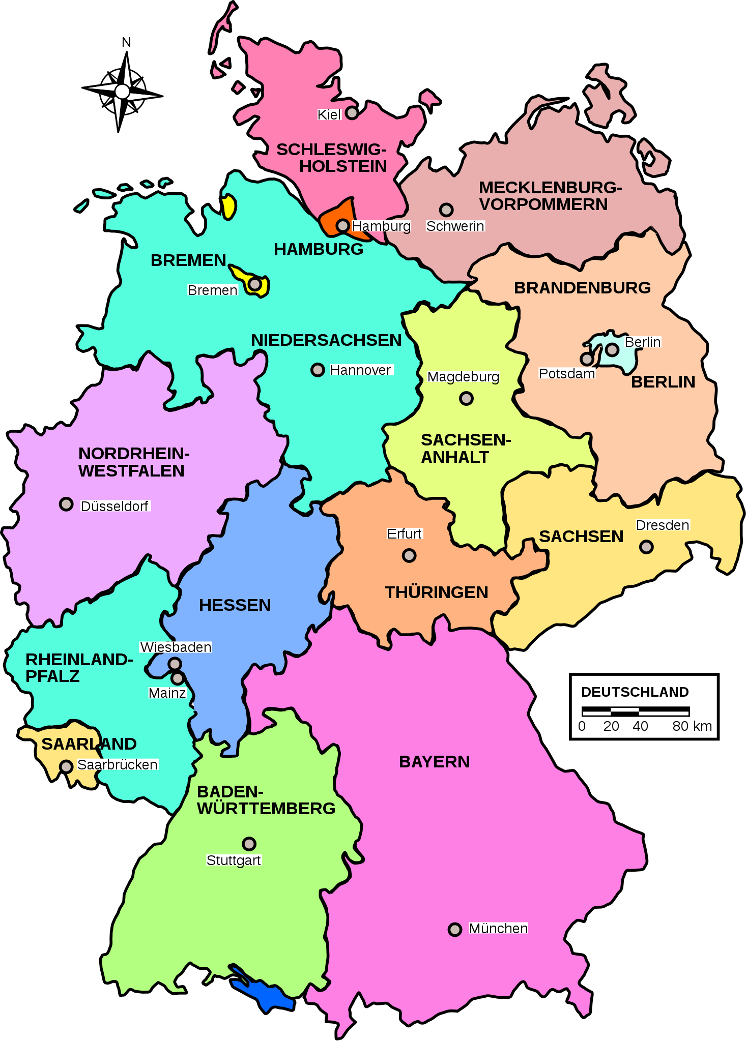
Deutsch: Deutsche Bundesländer Karte. |
||||||
| ڕێکەوت | |||||||
| سەرچاوە | Own work (image renamed from Image:Map germany.svg) | ||||||
| بەرھەمھێنەر | Patricia.fidi | ||||||
| ڕێپێدان (بەکارھێنانەوەی ئەم پەڕگەیە) |
|
||||||
| وەشانەکانی تر |
|


|
This SVG file contains embedded text that can be translated into your language, using any capable SVG editor, text editor or the SVG Translate tool. For more information see: About translating SVG files. |
مێژووی پەڕگە
کرتە بکە لەسەر یەکێک لە ڕێکەوت/کاتەکان بۆ بینینی پەڕگەکە بەو شێوەی لەو کاتەدا بووە.
| ڕێکەوت/کات | ھێما | ئەندازە | بەکارھێنەر | تێبینی | |
|---|---|---|---|---|---|
| هەنووکە | ٢٠:١٠، ١٣ی ئابی ٢٠١١ | | ٥٢٢ لە ٧٢٩ (١٧١ کیلۆبایت) | Abani79 | minor improvement |
| ١٤:١٠، ٢٧ی ئەیلوولی ٢٠٠٩ |  | ٥٢٢ لە ٧٢٩ (٢٠٨ کیلۆبایت) | Contro993 | Reverted to version as of 16:12, 18 June 2007 | |
| ١٤:٠٨، ٢٧ی ئەیلوولی ٢٠٠٩ |  | ٥٢٢ لە ٧٢٩ (٢٠٩ کیلۆبایت) | Contro993 | Italian version of the map. | |
| ١٦:١٢، ١٨ی حوزەیرانی ٢٠٠٧ |  | ٥٢٢ لە ٧٢٩ (٢٠٨ کیلۆبایت) | Bibi Saint-Pol | s/Postdam/Potsdam/ | |
| ٠٠:٠٩، ٢٧ی شوباتی ٢٠٠٧ |  | ٥٢٢ لە ٧٢٩ (٢٠٨ کیلۆبایت) | Bibi Saint-Pol | {{Information |Description= {{de|Deuschland Karte.}} {{en|Map of Germany.}} |Source=Own work (image renamed from Image:Map germany.svg) |Date=2006-08-06 |Author=Patricia.fidi |Permission={{PD-OpenClipart|http://openclipart.org} |
بەکارھێنانی پەڕگە
ئەم پەڕەیە ئەم پەڕگەیە بەکار دەھێنێت:
بەکارھێنانی سەرانسەریی پەڕگە
ئەم ویکیانەی دیکەی خوارەوەش ئەم پەڕگە بەکاردێنن:
- بەکارھێنان لە ar.wikipedia.org
- بەکارھێنان لە de.wikipedia.org
- Naturschutzgebiet (Deutschland)
- Portal Diskussion:Umwelt- und Naturschutz
- Liste der Justizvollzugsanstalten in Bayern
- Naturwaldreservat
- Nationalparks in Deutschland
- Bundesärztekammer
- Liste der Justizvollzugsanstalten in Brandenburg
- Liste der Ramsar-Gebiete in Deutschland
- Diskussion:Land (Deutschland)/Archiv/1
- Liste der Naturparks in Deutschland
- Liste der Justizvollzugsanstalten in Deutschland
- Benutzer:Ulflulfl/Karten
- Nationales Naturmonument
- Liste der Justizvollzugsanstalten in Rheinland-Pfalz
- Wikipedia:Redaktion Bilder/Charts
- Sächsische Landesärztekammer
- Liste der Justizvollzugsanstalten in Thüringen
- Bayerische Landesärztekammer
- Vorlage:Navigationsleiste Ärztekammer (Deutschland)
- Liste der Justizvollzugsanstalten in Schleswig-Holstein
- Vorlage:Navigationsleiste Listen der Justizvollzugsanstalten in Deutschland
- Liste der Biosphärenreservate in Deutschland
- Ärztekammer Westfalen-Lippe
- Ärztekammer Berlin
- Ärztekammer Nordrhein
- Liste der FFH-Gebiete in Deutschland
- Landesärztekammer Hessen
- Gesetz über Hilfen und Schutzmaßnahmen bei psychischen Krankheiten (Baden-Württemberg)
- Gesetz über Hilfen und Schutzmaßnahmen bei psychischen Krankheiten (Nordrhein-Westfalen)
- Brandenburgisches Psychisch-Kranken-Gesetz
- Hamburgisches Gesetz über Hilfen und Schutzmaßnahmen bei psychischen Krankheiten
- Sächsisches Gesetz über die Hilfen und die Unterbringung bei psychischen Krankheiten
- Psychischkrankengesetz
- Niedersächsisches Gesetz über Hilfen und Schutzmaßnahmen für psychisch Kranke
- Landesgesetz über Hilfen bei psychischen Erkrankungen
- Gesetz über Hilfen für psychisch Kranke und Schutzmaßnahmen des Landes Sachsen-Anhalt
- Thüringer Gesetz zur Hilfe und Unterbringung psychisch kranker Menschen
- Benutzer Diskussion:AsiTV
- Liste von Psychiatrien in Bayern
- Liste von Psychiatrien in Rheinland-Pfalz
- Landesärztekammer Baden-Württemberg
- Psychisch-Kranken-Hilfe-Gesetz (Hessen)
- Liste von Psychiatrien in Nordrhein-Westfalen
- Liste von psychiatrischen Kliniken in Berlin
- Liste von Psychiatrien in Hamburg
- Vorlage:Navigationsleiste Psychiatrische Kliniken in Deutschland
- Liste von Psychiatrien in der Freien Hansestadt Bremen
- Liste von Psychiatrien im Saarland
بینینی بەکارھێنانی گشتی زیاتری ئەم پەڕگەیە.