
پەڕگە:Map Crusader states 1190-en.svg

Size of this PNG preview of this SVG file: ٤٤١ لە ٦٠٠ پیکسەڵ. ڕێزەلووشنەکانی تر: ١٧٦ لە ٢٤٠ پیکسەڵ | ٣٥٣ لە ٤٨٠ پیکسەڵ | ٥٦٥ لە ٧٦٨ پیکسەڵ | ٧٥٣ لە ١٬٠٢٤ پیکسەڵ | ١٬٥٠٦ لە ٢٬٠٤٨ پیکسەڵ | ٩٧٨ لە ١٬٣٣٠ پیکسەڵ.
پەڕگەی سەرەکی (پەڕگەی SVG، بە ناو ٩٧٨ × ١٬٣٣٠ پیکسەڵ، قەبارەی پەڕگە: ٤٧٠ کیلۆبایت)
کورتە
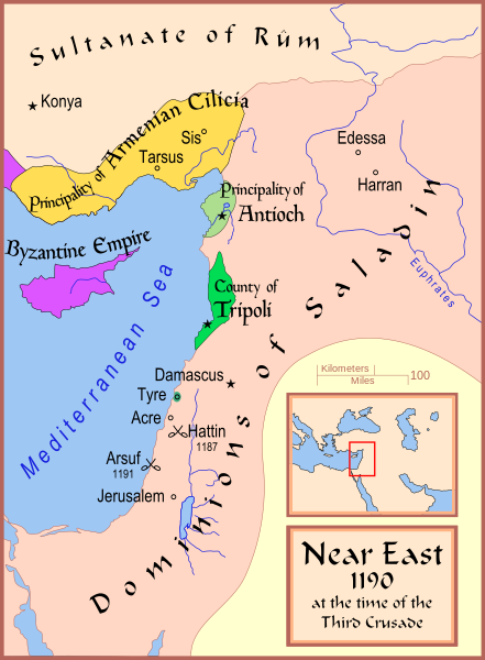
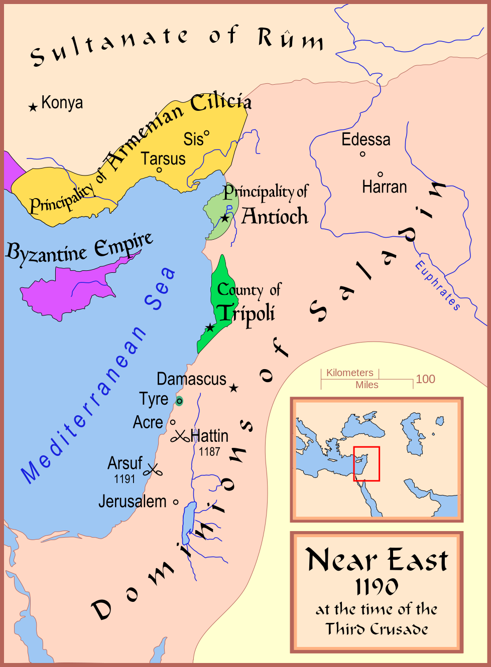
| وەسف | A map showing the Near East (the Levant) in 1190. |
| ڕێکەوت | |
| سەرچاوە | بەرھەمی خۆم |
| بەرھەمھێنەر | MapMaster |
| وەشانەکانی تر |
[]
See also |


References
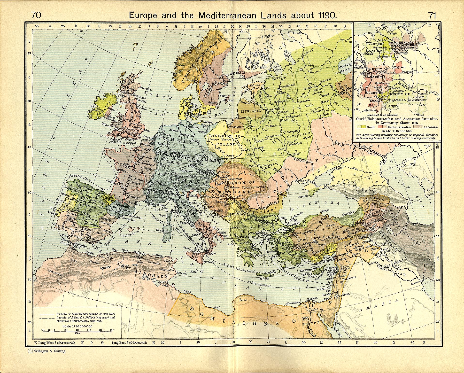
- Shepherd, William R. (1911) "Europe and the Mediterranean Lands about 1190"
مۆڵەتنامە
من، ھەڵگری مافی لەبەرگرتنەوەی ئەم بەرھەمە، لەژێر ئەم مۆڵەتنامەیانەدا بڵاوی دەکەمەوە:

|
ڕێگەدراوە بە لەبەرگرتنەوە، دابەشکردن ھەروەھا/یان سازاندنی ئەم بەڵگەنامەیە لەژێر مەرجی مۆڵەتی GNU بۆ بەڵگەنامەی ئازاد، وەشانی ١.٢ یان ھەر وەشانێکی تری دواتر کە بڵاوکراوەتەوە لەلایەن دامەزراوەی بەرنامەی ئازاد، بەبێ ھیچ بەشێکی جیاواز، بەبێ نووسین لەسەر بەرگی پێشەوە و دواوەی. وێنەیەک لەمۆڵەتەکە لە بەشێکدا ھەیە کە ناوی مۆڵەتی GNU بۆ بەڵگەنامەی ئازادە. |
This file is licensed under the Creative Commons Attribution-Share Alike 4.0 International, 3.0 Unported, 2.5 Generic, 2.0 Generic and 1.0 Generic license.
- تۆ ئازادی:
- بۆ بڵاکردنەوە – بۆ کۆپی کردن، دابەشکردن و دەستبەدەست ناردنی
- بۆ تێکەڵکردنەوە – بۆ سازاندنی کارەکە
- بەم مەرجانەی خوارەوە:
- دانەپاڵ – پێویستە باوەڕی گونجاو بدەیت، بەستەرێک بۆ مۆڵەتەکە دابین بکەیت و ئاماژە بەوە بکەیت کە ئایا گۆڕانکاری کراوە یان نا. دەتوانیت بە هەر شێوەیەکی گونجاو ئەوە بکەیت، بەڵام بە شێوەیەک نا کە وا دەربکەوێت کە مۆڵەتدەر پشتگیری تۆ یان بەکارهێنانەکەت بکات.
- بڵاوکردنەوەی گونجاو – ئەگەر لەسەر بنەمای ئەم کارە تێکەڵ، گۆڕان، یان ساز بکەی، پێویستە بەشدارییەکانت بە هەمان مۆڵەت یان هاوشێوەی مۆڵەتی ئەسڵی دابەش بکەی.
دەتوانی مۆڵەتنامەی دڵخوازت ھەڵبژێریت.
مێژووی پەڕگە
کرتە بکە لەسەر یەکێک لە ڕێکەوت/کاتەکان بۆ بینینی پەڕگەکە بەو شێوەی لەو کاتەدا بووە.
| ڕێکەوت/کات | ھێما | ئەندازە | بەکارھێنەر | تێبینی | |
|---|---|---|---|---|---|
| هەنووکە | ١٧:٣٥، ١٣ی شوباتی ٢٠٠٨ | | ٩٧٨ لە ١٬٣٣٠ (٤٧٠ کیلۆبایت) | MapMaster | Slight changes |
| ١٧:٢٨، ١٣ی شوباتی ٢٠٠٨ |  | ٩٧٨ لە ١٬٣٣٠ (٤٦٤ کیلۆبایت) | MapMaster | {{Information |Description=A map showing the Near East (the Levant) in 1190. |Source=self-made |Date=12 Feb 2008 |Author= MapMaster |Permission= |other_versions=see below }} ==Other versions== *[[:Image:Die Levante 1135 |
بەکارھێنانی پەڕگە
ئەم پەڕەیە ئەم پەڕگەیە بەکار دەھێنێت:
بەکارھێنانی سەرانسەریی پەڕگە
ئەم ویکیانەی دیکەی خوارەوەش ئەم پەڕگە بەکاردێنن:
- بەکارھێنان لە arz.wikipedia.org
- بەکارھێنان لە azb.wikipedia.org
- بەکارھێنان لە az.wikipedia.org
- بەکارھێنان لە be.wikipedia.org
- بەکارھێنان لە bg.wikipedia.org
- بەکارھێنان لە br.wikipedia.org
- بەکارھێنان لە da.wikipedia.org
- بەکارھێنان لە de.wikipedia.org
- بەکارھێنان لە el.wikipedia.org
- بەکارھێنان لە en.wikipedia.org
- Kingdom of Jerusalem
- Richard I of England
- 1190
- Third Crusade
- Guy of Lusignan
- Battle of Arsuf
- Conrad of Montferrat
- Crusader states
- Krak des Chevaliers
- Siege of Acre (1189–1191)
- Bohemond III of Antioch
- Bohemond IV of Antioch
- Talk:Battle of Hattin
- Crusades
- Timeline of the Kingdom of Jerusalem
- Timeline of the Principality of Antioch
- User:Falcaorib
- Fall of Outremer
- بەکارھێنان لە et.wikipedia.org
- بەکارھێنان لە fi.wikipedia.org
- بەکارھێنان لە he.wikipedia.org
- بەکارھێنان لە hr.wikipedia.org
- بەکارھێنان لە hu.wikipedia.org
- بەکارھێنان لە hy.wikipedia.org
- بەکارھێنان لە hyw.wikipedia.org
بینینی بەکارھێنانی گشتی زیاتری ئەم پەڕگەیە.