
پەڕگە:Kingdom of Prussia 1870.svg

Size of this PNG preview of this SVG file: ٤٥٠ لە ٤٥٦ پیکسەڵ. ڕێزەلووشنەکانی تر: ٢٣٧ لە ٢٤٠ پیکسەڵ | ٤٧٤ لە ٤٨٠ پیکسەڵ | ٧٥٨ لە ٧٦٨ پیکسەڵ | ١٬٠١١ لە ١٬٠٢٤ پیکسەڵ | ٢٬٠٢١ لە ٢٬٠٤٨ پیکسەڵ.
پەڕگەی سەرەکی (پەڕگەی SVG، بە ناو ٤٥٠ × ٤٥٦ پیکسەڵ، قەبارەی پەڕگە: ٧٠٥ کیلۆبایت)
کورتە
This W3C-unspecified vector image was created with Inkscape .


.svg)
.svg)
.svg)
.svg)
.svg)


.svg)
.svg)
.svg)


.png)
.png)


.svg)


.svg)

.svg)


.svg)
.svg)
.svg)
.svg)


.svg)
.png)


.svg)


.svg)
.svg)


.svg)


.svg)


.svg)
.svg)
.svg)
.svg)
.svg)
.svg)
.svg)
_cropped.svg)
.svg)
.svg)
.svg)
.svg)
.svg)
.svg)
.svg)
.svg)
.svg)
.svg)
.svg)
.svg)
.svg)
.svg)
.svg)
.svg)
.svg)
.svg)
.svg)
.svg)
.svg)
.svg)
.svg)
.svg)
.svg)
.svg)
.svg)
.svg)
.svg)
.svg)
.svg)
.svg)
.svg)
.svg)
.svg)
.svg)
.svg)
.svg)
.svg)
.svg)
.svg)
.svg)
.svg)
.svg)
.svg)
مۆڵەتنامە
This file is licensed under the Creative Commons Attribution-Share Alike 4.0 International license.
- تۆ ئازادی:
- بۆ بڵاکردنەوە – بۆ کۆپی کردن، دابەشکردن و دەستبەدەست ناردنی
- بۆ تێکەڵکردنەوە – بۆ سازاندنی کارەکە
- بەم مەرجانەی خوارەوە:
- دانەپاڵ – پێویستە باوەڕی گونجاو بدەیت، بەستەرێک بۆ مۆڵەتەکە دابین بکەیت و ئاماژە بەوە بکەیت کە ئایا گۆڕانکاری کراوە یان نا. دەتوانیت بە هەر شێوەیەکی گونجاو ئەوە بکەیت، بەڵام بە شێوەیەک نا کە وا دەربکەوێت کە مۆڵەتدەر پشتگیری تۆ یان بەکارهێنانەکەت بکات.
- بڵاوکردنەوەی گونجاو – ئەگەر لەسەر بنەمای ئەم کارە تێکەڵ، گۆڕان، یان ساز بکەی، پێویستە بەشدارییەکانت بە هەمان مۆڵەت یان هاوشێوەی مۆڵەتی ئەسڵی دابەش بکەی.
مێژووی پەڕگە
کرتە بکە لەسەر یەکێک لە ڕێکەوت/کاتەکان بۆ بینینی پەڕگەکە بەو شێوەی لەو کاتەدا بووە.
| ڕێکەوت/کات | ھێما | ئەندازە | بەکارھێنەر | تێبینی | |
|---|---|---|---|---|---|
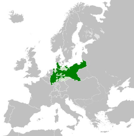
| هەنووکە | ٠٢:٥٤، ١ی حوزەیرانی ٢٠١٦ | | ٤٥٠ لە ٤٥٦ (٧٠٥ کیلۆبایت) | Alphathon | Various corrections to the states of the North German Confederation |
| ٠٥:٢٢، ٣١ی ئایاری ٢٠١٦ |  | ٤٥٠ لە ٤٥٦ (٦٦٢ کیلۆبایت) | Alphathon | Minor corrections (Tarasp and post-1818 German Confederation border change) | |
| ٠٢:٤٠، ٣١ی ئایاری ٢٠١٦ |  | ٤٥٠ لە ٤٥٦ (٦٦٢ کیلۆبایت) | Alphathon | == {{int:filedesc}} == {{Inkscape}} {{Information |Description={{en|A map of the en:Kingdom of Prussia within the North German Confederation and within Europe circa 1870 CE.}} |Source= {{Derived from|Blank_map_of_Europe.svg|display=50}} |Da... |
بەکارھێنانی پەڕگە
ئەم پەڕەیە ئەم پەڕگەیە بەکار دەھێنێت:
بەکارھێنانی سەرانسەریی پەڕگە
ئەم ویکیانەی دیکەی خوارەوەش ئەم پەڕگە بەکاردێنن:
- بەکارھێنان لە af.wiktionary.org
- بەکارھێنان لە ar.wikipedia.org
- بەکارھێنان لە bn.wikipedia.org
- بەکارھێنان لە en.wikipedia.org
- بەکارھێنان لە eo.wiktionary.org
- بەکارھێنان لە es.wikipedia.org
- بەکارھێنان لە es.wiktionary.org
- بەکارھێنان لە eu.wikipedia.org
- بەکارھێنان لە fa.wikipedia.org
- بەکارھێنان لە fi.wikipedia.org
- بەکارھێنان لە he.wikipedia.org
- بەکارھێنان لە hu.wikipedia.org
- بەکارھێنان لە is.wikipedia.org
- بەکارھێنان لە it.wikipedia.org
- بەکارھێنان لە li.wiktionary.org
- بەکارھێنان لە lld.wikipedia.org
- بەکارھێنان لە lt.wikipedia.org
- بەکارھێنان لە mn.wikipedia.org
- بەکارھێنان لە pl.wikipedia.org
- بەکارھێنان لە rue.wikipedia.org
- بەکارھێنان لە ru.wikipedia.org
- بەکارھێنان لە ru.wiktionary.org
- بەکارھێنان لە sk.wikipedia.org
- بەکارھێنان لە szl.wikipedia.org
- بەکارھێنان لە tr.wikipedia.org
- بەکارھێنان لە uk.wikipedia.org
- بەکارھێنان لە uz.wikipedia.org
- بەکارھێنان لە xmf.wikipedia.org
- بەکارھێنان لە zh.wikipedia.org