پەڕگە:Indus.A2002274.0610.1km.jpg

قەبارەی ئەم پێشبینینە: ٤٥٨ لە ٥٩٩ پیکسەڵ. ڕێزەلووشنەکانی تر: ١٨٣ لە ٢٤٠ پیکسەڵ | ٣٦٧ لە ٤٨٠ پیکسەڵ | ٥٨٧ لە ٧٦٨ پیکسەڵ | ٧٨٣ لە ١٬٠٢٤ پیکسەڵ | ١٬٣٠٠ لە ١٬٧٠٠ پیکسەڵ.
پەڕگەی سەرەکی (١٬٣٠٠ × ١٬٧٠٠ پیکسڵ، قەبارەی پەڕگە: ٤٨٠ کیلۆبایت، جۆری ئێم ئای ئێم ئی: image/jpeg)
مێژووی پەڕگە
کرتە بکە لەسەر یەکێک لە ڕێکەوت/کاتەکان بۆ بینینی پەڕگەکە بەو شێوەی لەو کاتەدا بووە.
| ڕێکەوت/کات | ھێما | ئەندازە | بەکارھێنەر | تێبینی | |
|---|---|---|---|---|---|
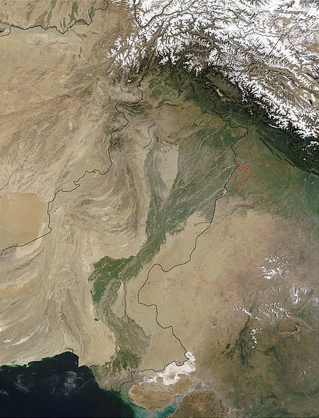
| هەنووکە | ١٣:٠٣، ٢٨ی ئازاری ٢٠٠٨ |  | ١٬٣٠٠ لە ١٬٧٠٠ (٤٨٠ کیلۆبایت) | File Upload Bot (Magnus Manske) | {{BotMoveToCommons|en.wikipedia}} {{Information |Description={{en|en:Satellite image of the en:Indus River basin. Red dots indicate fires. International boundaries are superimposed; the boundary through en:Jammu and Kashmir reflects the [[ |
بەکارھێنانی پەڕگە
ئەم پەڕەیە ئەم پەڕگەیە بەکار دەھێنێت:
بەکارھێنانی سەرانسەریی پەڕگە
ئەم ویکیانەی دیکەی خوارەوەش ئەم پەڕگە بەکاردێنن:
- بەکارھێنان لە af.wikipedia.org
- بەکارھێنان لە ar.wikipedia.org
- بەکارھێنان لە arz.wikipedia.org
- بەکارھێنان لە ast.wikipedia.org
- بەکارھێنان لە as.wikipedia.org
- بەکارھێنان لە azb.wikipedia.org
- بەکارھێنان لە az.wikipedia.org
- بەکارھێنان لە ba.wikipedia.org
- بەکارھێنان لە be-tarask.wikipedia.org
- بەکارھێنان لە bh.wikipedia.org
- بەکارھێنان لە bn.wikipedia.org
- بەکارھێنان لە bo.wikipedia.org
- بەکارھێنان لە br.wikipedia.org
- بەکارھێنان لە bxr.wikipedia.org
- بەکارھێنان لە ca.wikipedia.org
- بەکارھێنان لە ceb.wikipedia.org
- بەکارھێنان لە ce.wikipedia.org
- بەکارھێنان لە cy.wikipedia.org
- بەکارھێنان لە da.wikipedia.org
- بەکارھێنان لە en.wikipedia.org
- بەکارھێنان لە eo.wikipedia.org
- بەکارھێنان لە es.wikipedia.org
- بەکارھێنان لە fa.wikipedia.org
- بەکارھێنان لە fiu-vro.wikipedia.org
- بەکارھێنان لە gd.wikipedia.org
- بەکارھێنان لە gl.wikipedia.org
- بەکارھێنان لە hi.wikipedia.org
- بەکارھێنان لە hy.wikipedia.org
- بەکارھێنان لە ia.wikipedia.org
- بەکارھێنان لە id.wikipedia.org
- بەکارھێنان لە ilo.wikipedia.org
- بەکارھێنان لە incubator.wikimedia.org
- بەکارھێنان لە is.wikipedia.org
- بەکارھێنان لە it.wikipedia.org
بینینی بەکارھێنانی گشتی زیاتری ئەم پەڕگەیە.


