پەڕگە:Gibraltar map-en.svg
ناوەڕۆکی پەڕە بە زمانەکانی تر پشتگیریی لێ ناکرێت.
لە ئینسایکڵۆپیدیای ئازادی ویکیپیدیاوە

پەڕگەی سەرەکی(پەڕگەی SVG، بە ناو ٢٬٠٢٠ × ٣٬١٤٠ پیکسەڵ، قەبارەی پەڕگە: ٢٨٩ کیلۆبایت)

ئەم پەڕگە لە Wikimedia Commonsەوەیە و لەوانەیە لە پڕۆژەکانی دیکەش بەکار ھاتبێت. پێناسەکەی لەسەر پەڕەی وەسفی پەڕگەکە لە خوارەوە نیشان دراوە.

وێنە of the year
وێنە of the year
Featured وێنە

ویکیمیدیا کۆمنز

ئەم وێنەیە پێ بەخشرا لە وێنەی گشتی جیھان ٢٠٠٧.
ئەم وێنەیە ھەڵبژێردراو بوو لە ویکیمیدیا کۆمنز (Featured pictures) و ھەڵبژێردراوە بۆ ئەوەی ببێت بە باشترین وێنەکان.

ئەگەر وێنەیەکی ھاوشێوەت ھەبوو نموونە دەتواندرێت باربکرێت لەژێر مۆڵەتنامەی Commons:Licensing مۆڵەتنامەی گونجاو، ھەستە بە باری کە، و مافی بپارێزە، و بیپاڵێوە.

کورتە

Camera location٣٦° ٠٨′ ٠٠″ N, ٥° ٢١′ ٠٠″ W Kartographer map based on OpenStreetMap.View this and other nearby images on: OpenStreetMapinfo
وەسف
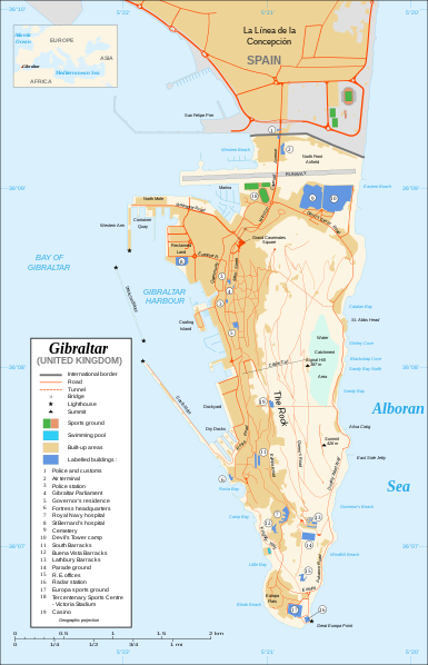
Čeština: Mapa ostrova Gibraltar v angličtině.
English: Map in English of Gibraltar.
Français : * Sujet : Carte en anglais de Gibraltar ;
  • Sources : Création personnelle ;
  • Carte créée à partir de captures d'écran d'images satellite de Google Earth d'un point de vue placé à 1,18 km d'altitude (imagerie disponible de novembre 2007) ;
  • Références complémentaires :
  • Échelle approximative : 1:40 000 (précision : environ 10 m) ;
  • Note : Largeur du tracé des routes proportionnelle à la réalité ;
  • Auteur : Eric Gaba (fr:Sting) ;
  • Date : Novembre 2007.
Português: Mapa (em Inglês) de Gibraltar.
ڕێکەوت
سەرچاوە Own work ;
Map created using screenshots of Google Earth satellite imagery from a point of view located at 1.18 km of altitude (available imagery of November 2007) ;
Other references :
* CIA map ;
* Gibnet map ;
* U.K. MoD map
Locator map : Image:Blank_map_of_South_Europe_and_North_Africa.svg (modified) created by Historicair ;
Approximate scale : 1:40,000 (accuracy : about 10 m)
Note : The roads width is proportional to reality
بەرھەمھێنەر Eric Gaba (Sting)
ڕێپێدان
(بەکارھێنانەوەی ئەم پەڕگەیە)
Attribution and Share-Alike required
وەشانەکانی تر

[دەستکاری]

Disputed isthmus and land
SVG genesis
InfoField
 
The SVG code is valid.
 
This map was created with Inkscape…important.
 
 This map uses embedded text that can be easily translated using a text editor.

مۆڵەتنامە

من، ھەڵگری مافی لەبەرگرتنەوەی ئەم بەرھەمە، لەژێر ئەم مۆڵەتنامەیانەدا بڵاوی دەکەمەوە:
GNU head ڕێگەدراوە بە لەبەرگرتنەوە، دابەشکردن ھەروەھا/یان سازاندنی ئەم بەڵگەنامەیە لەژێر مەرجی مۆڵەتی GNU بۆ بەڵگەنامەی ئازاد، وەشانی ١.٢ یان ھەر وەشانێکی تری دواتر کە بڵاوکراوەتەوە لەلایەن دامەزراوەی بەرنامەی ئازاد، بەبێ ھیچ بەشێکی جیاواز، بەبێ نووسین لەسەر بەرگی پێشەوە و دواوەی. وێنەیەک لەمۆڵەتەکە لە بەشێکدا ھەیە کە ناوی مۆڵەتی GNU بۆ بەڵگەنامەی ئازادە.
w:en:Creative Commons
دانەپاڵ بڵاوکردنەوەی گونجاو
This file is licensed under the Creative Commons Attribution-Share Alike 4.0 International, 3.0 Unported, 2.5 Generic, 2.0 Generic and 1.0 Generic license.
تۆ ئازادی:
  • بۆ بڵاکردنەوە – بۆ کۆپی کردن، دابەشکردن و دەستبەدەست ناردنی
  • بۆ تێکەڵکردنەوە – بۆ سازاندنی کارەکە
بەم مەرجانەی خوارەوە:
  • دانەپاڵ – پێویستە باوەڕی گونجاو بدەیت، بەستەرێک بۆ مۆڵەتەکە دابین بکەیت و ئاماژە بەوە بکەیت کە ئایا گۆڕانکاری کراوە یان نا. دەتوانیت بە هەر شێوەیەکی گونجاو ئەوە بکەیت، بەڵام بە شێوەیەک نا کە وا دەربکەوێت کە مۆڵەتدەر پشتگیری تۆ یان بەکارهێنانەکەت بکات.
  • بڵاوکردنەوەی گونجاو – ئەگەر لەسەر بنەمای ئەم کارە تێکەڵ، گۆڕان، یان ساز بکەی، پێویستە بەشدارییەکانت بە هەمان مۆڵەت یان هاوشێوەی مۆڵەتی ئەسڵی دابەش بکەی.
دەتوانی مۆڵەتنامەی دڵخوازت ھەڵبژێریت.

لێدوانەکان

Add a one-line explanation of what this file represents

بەندەکانی لەم پەڕگەیەدا دەردەکەون

depicts ئینگلیزی

تشرینی دووەم 2007

36°7'59.999"N, 5°21'0.000"W

media type ئینگلیزی

image/svg+xml

مێژووی پەڕگە

کرتە بکە لەسەر یەکێک لە ڕێکەوت/کاتەکان بۆ بینینی پەڕگەکە بەو شێوەی لەو کاتەدا بووە.

ڕێکەوت/کاتھێمائەندازەبەکارھێنەرتێبینی
هەنووکە‏٢٠:١٠، ٢١ی شوباتی ٢٠٢٠ھێما بۆ وەشانی  ‏٢٠:١٠، ٢١ی شوباتی ٢٠٢٠٢٬٠٢٠ لە ٣٬١٤٠ (٢٨٩ کیلۆبایت)JoKalliauermalformed svg (compare firefox/chrome rendering with librsvg-rendering) actually firefox/chrome were correct, also it looks wrong
‏٠٦:٠١، ٢٩ی حوزەیرانی ٢٠١٧ھێما بۆ وەشانی  ‏٠٦:٠١، ٢٩ی حوزەیرانی ٢٠١٧٢٬٠٢٠ لە ٣٬١٤٠ (٥٣٨ کیلۆبایت)Wereldburger758Removal error in file. Valid SVG now.
‏٢١:٥٢، ٢٧ی ئابی ٢٠٠٨ھێما بۆ وەشانی  ‏٢١:٥٢، ٢٧ی ئابی ٢٠٠٨٢٬٠٢٠ لە ٣٬١٤٠ (٥٦٩ کیلۆبایت)RedCoatRemove "claimed by Spain", completely gratuitous for a map
‏١١:٢٨، ١١ی کانوونی یەکەمی ٢٠٠٧ھێما بۆ وەشانی  ‏١١:٢٨، ١١ی کانوونی یەکەمی ٢٠٠٧٢٬٠٢٠ لە ٣٬١٤٠ (٥٧٠ کیلۆبایت)StingNotification of the Spanish claims
‏١٤:٤٠، ٢٧ی تشرینی دووەمی ٢٠٠٧ھێما بۆ وەشانی  ‏١٤:٤٠، ٢٧ی تشرینی دووەمی ٢٠٠٧٢٬٠٢٠ لە ٣٬١٤٠ (٥٦٩ کیلۆبایت)StingAdditional names ; up-to-date corrections
‏٢١:٣٥، ٢٦ی تشرینی دووەمی ٢٠٠٧ھێما بۆ وەشانی  ‏٢١:٣٥، ٢٦ی تشرینی دووەمی ٢٠٠٧٢٬٠٢٠ لە ٣٬١٤٠ (٥٦١ کیلۆبایت)RedCoatHouse of Assembly → Gibraltar Parliament
‏١٩:٥١، ٢٦ی تشرینی دووەمی ٢٠٠٧ھێما بۆ وەشانی  ‏١٩:٥١، ٢٦ی تشرینی دووەمی ٢٠٠٧٢٬٠٢٠ لە ٣٬١٤٠ (٥٦١ کیلۆبایت)Sting+ info
‏١٤:١٢، ٢٦ی تشرینی دووەمی ٢٠٠٧ھێما بۆ وەشانی  ‏١٤:١٢، ٢٦ی تشرینی دووەمی ٢٠٠٧٢٬٠٢٠ لە ٣٬١٤٠ (٥٦١ کیلۆبایت)Sting+ info
‏١٣:٢١، ٢٦ی تشرینی دووەمی ٢٠٠٧ھێما بۆ وەشانی  ‏١٣:٢١، ٢٦ی تشرینی دووەمی ٢٠٠٧٢٬٠٢٠ لە ٣٬١٤٠ (٥٦١ کیلۆبایت)Sting{{Information |Description=Map in English of Gibraltar |Source=Own work ;<br/>Map created using screenshots of Google Earth satellite imagery from a point of view located at 1.18 km of altitude (available image

ھیچ پەڕەیەک نییە کە ئەم پەڕگەیە بەکاربھێنێت.

بەکارھێنانی سەرانسەریی پەڕگە

ئەم ویکیانەی دیکەی خوارەوەش ئەم پەڕگە بەکاردێنن:

دراوی مێتا