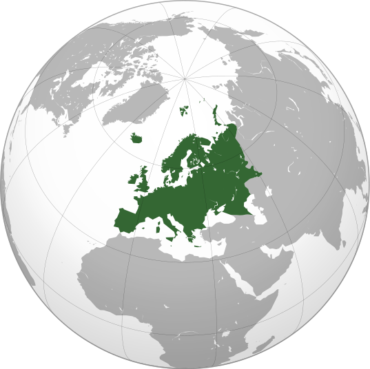
پەڕگە:Europe orthographic Caucasus Urals boundary.svg

Size of this PNG preview of this SVG file: ٥٣٧ لە ٥٣٦ پیکسەڵ. ڕێزەلووشنەکانی تر: ٢٤٠ لە ٢٤٠ پیکسەڵ | ٤٨١ لە ٤٨٠ پیکسەڵ | ٧٦٩ لە ٧٦٨ پیکسەڵ | ١٬٠٢٦ لە ١٬٠٢٤ پیکسەڵ | ٢٬٠٥٢ لە ٢٬٠٤٨ پیکسەڵ.
پەڕگەی سەرەکی (پەڕگەی SVG، بە ناو ٥٣٧ × ٥٣٦ پیکسەڵ، قەبارەی پەڕگە: ٧٧ کیلۆبایت)
مێژووی پەڕگە
کرتە بکە لەسەر یەکێک لە ڕێکەوت/کاتەکان بۆ بینینی پەڕگەکە بەو شێوەی لەو کاتەدا بووە.
| ڕێکەوت/کات | ھێما | ئەندازە | بەکارھێنەر | تێبینی | |
|---|---|---|---|---|---|
| هەنووکە | ١٣:٣٢، ٤ی ئەیلوولی ٢٠٢٢ |  | ٥٣٧ لە ٥٣٦ (٧٧ کیلۆبایت) | M.Bitton | Reverted to version as of 12:03, 4 September 2022 (UTC): per COM:OVERWRITE |
| ١٣:٣٠، ٤ی ئەیلوولی ٢٠٢٢ |  | ٥٣٧ لە ٥٣٦ (١٧٧ کیلۆبایت) | Рагин1987 | Small correction | |
| ١٢:٠٣، ٤ی ئەیلوولی ٢٠٢٢ |  | ٥٣٧ لە ٥٣٦ (٧٧ کیلۆبایت) | M.Bitton | Reverted to version as of 05:48, 12 March 2019 (UTC): per COM:OVERWRITE + fake svg | |
| ١٩:١٢، ٣٠ی ئابی ٢٠٢٢ |  | ٢٬٠٥٢ لە ٢٬٠٤٨ (٨٧٤ کیلۆبایت) | Рагин1987 | More correct visualization of the dividing line on the territory of the Caucasus Range | |
| ٠٥:٤٨، ١٢ی ئازاری ٢٠١٩ |  | ٥٣٧ لە ٥٣٦ (٧٧ کیلۆبایت) | AndreyKva | Optimized. | |
| ١٩:٢٥، ٣ی ئازاری ٢٠١٦ |  | ٥٣٧ لە ٥٣٦ (١٩٧ کیلۆبایت) | Denniss | Reverted to version as of 13:27, 19 October 2014 (UTC) | |
| ١٨:٣٧، ٣ی ئازاری ٢٠١٦ |  | ٥٣٧ لە ٥٣٦ (٢٣٩ کیلۆبایت) | Ercwlff | UC UC UC | |
| ١٣:٢٧، ١٩ی تشرینی یەکەمی ٢٠١٤ |  | ٥٣٧ لە ٥٣٦ (١٩٧ کیلۆبایت) | Deni Mataev | Again, The entirety of Georgia is not in Europe geographically, only North Eastern parts are | |
| ٢٠:٠٥، ١٨ی تشرینی یەکەمی ٢٠١٤ |  | ٥٣٧ لە ٥٣٦ (٢٣٨ کیلۆبایت) | Politologia | Reverted to version as of 10:57, 18 October 2014 In all maps Georgia is part of Georgia. There is at list 10 versions of borders of Europe in most of them Georgia is part of Europa | |
| ٢٠:٠٤، ١٨ی تشرینی یەکەمی ٢٠١٤ |  | ٥٣٧ لە ٥٣٦ (٢٣٨ کیلۆبایت) | Politologia | Reverted to version as of 10:57, 18 October 2014 In all maps Georgia is part of Georgia. |
بەکارھێنانی پەڕگە
ئەم پەڕەیە ئەم پەڕگەیە بەکار دەھێنێت:
بەکارھێنانی سەرانسەریی پەڕگە
ئەم ویکیانەی دیکەی خوارەوەش ئەم پەڕگە بەکاردێنن:
- بەکارھێنان لە ab.wikipedia.org
- بەکارھێنان لە ace.wikipedia.org
- بەکارھێنان لە ady.wikipedia.org
- بەکارھێنان لە af.wikipedia.org
- بەکارھێنان لە ar.wikipedia.org
- بوابة:آسيا
- بوابة:أوروبا
- بوابة:إفريقيا
- بوابة:القارة القطبية الجنوبية
- بوابة:القارة القطبية الجنوبية/بوابات شقيقة
- قائمة جوازات السفر
- بوابة:تركيا
- بوابة:تركيا/بوابات شقيقة
- بوابة:جغرافيا/مقالة مختارة/أرشيف
- المرأة في تركيا
- بوابة:أوروبا/واجهة
- بوابة:تصفح
- بوابة:تصفح/جغرافيا
- قائمة مفاتيح الاتصال الدولية
- المرأة في ألمانيا
- بوابة:إسطنبول
- بوابة:آسيا/بوابات شقيقة
- ويكيبيديا:مقالة الصفحة الرئيسية المختارة/398
- بوابة:جغرافيا/مقالة مختارة/21
- معاملة المثليين في أوروبا
- المرأة في أوروبا
- المرأة في البرتغال
- المرأة في فنلندا
- المرأة في مقدونيا الشمالية
- المرأة في ترانسنيستريا
- المرأة في الفاتيكان
- المرأة في أذربيجان
- المرأة في اليونان
- المرأة في ألبانيا
- المرأة في إيطاليا
- المرأة في الجبل الأسود
بینینی بەکارھێنانی گشتی زیاتری ئەم پەڕگەیە.


