
پەڕگە:CIS mapwithnumbers.png
قەبارەی ئەم پێشبینینە: ٨٠٠ لە ٥٤٧ پیکسەڵ. ڕێزەلووشنەکانی تر: ٣٢٠ لە ٢١٩ پیکسەڵ | ٦٤٠ لە ٤٣٨ پیکسەڵ | ١٬٠٢٤ لە ٧٠١ پیکسەڵ | ١٬٣٥٦ لە ٩٢٨ پیکسەڵ.
پەڕگەی سەرەکی (١٬٣٥٦ × ٩٢٨ پیکسڵ، قەبارەی پەڕگە: ٦٢ کیلۆبایت، جۆری ئێم ئای ئێم ئی: image/png)
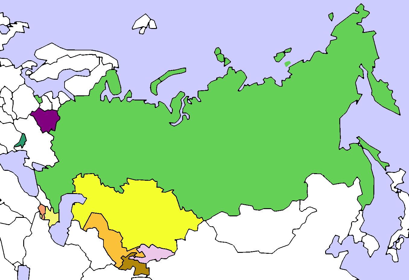
| وەسف | Map of the Commonwealth of Independent States (CIS). Created by User:Aris Katsaris, based on Image:Soviet Union Map.png |
| ڕێکەوت | (UTC) |
| سەرچاوە | |
| بەرھەمھێنەر |
|
| This is a retouched picture, which means that it has been digitally altered from its original version. Modifications: added colours and numbers. The original can be viewed here: CIS Map.png:
|
من، ھەڵگری مافی لەبەرگرتنەوەی ئەم بەرھەمە، لەژێر ئەم مۆڵەتنامەیەدا بڵاوی دەکەمەوە:

|
ڕێگەدراوە بە لەبەرگرتنەوە، دابەشکردن ھەروەھا/یان سازاندنی ئەم بەڵگەنامەیە لەژێر مەرجی مۆڵەتی GNU بۆ بەڵگەنامەی ئازاد، وەشانی ١.٢ یان ھەر وەشانێکی تری دواتر کە بڵاوکراوەتەوە لەلایەن دامەزراوەی بەرنامەی ئازاد، بەبێ ھیچ بەشێکی جیاواز، بەبێ نووسین لەسەر بەرگی پێشەوە و دواوەی. وێنەیەک لەمۆڵەتەکە لە بەشێکدا ھەیە کە ناوی مۆڵەتی GNU بۆ بەڵگەنامەی ئازادە. |
| ئەم پەڕگەیە لە ژێر مۆڵەتنامەی | ||
| ||
| This licensing tag was added to this file as part of the GFDL licensing update. |
Original upload log
This image is a derivative work of the following images:
- File:_CIS_Map.png licensed with GFDL, GFDL/en
- 2008-08-14T21:32:15Z Voland77 1356x928 (110892 Bytes) update: according to the CIS treaty countries willing to exit the organization have to announce this intention 12 month before they can actually leave it.
- 2008-08-14T15:56:03Z Voland77 1356x928 (128298 Bytes) update (Georgia withdrawal)
- 2008-08-13T17:07:35Z Переход Артур 1356x928 (52266 Bytes) {{Information |Description=Map of the Commonwealth of Independent States (CIS). |Source= |Date= |Author=Created by [[User:Aris Katsaris]], based on [[:Image:Soviet Union Map.png]] |Permission= |other_versions= }} {{GFDL}} {
- 2008-08-12T21:54:56Z Akhristov 1356x928 (26542 Bytes) "Official Website" isn't working, I don't see how you checked. Let's quit this war. (Added Moldova as Associate Member)
- 2008-08-12T21:42:46Z Переход Артур 1356x928 (23233 Bytes) According to the official website of the organiazation Ukraine is a member of CIS
- 2008-08-12T21:35:52Z Akhristov 1356x928 (26564 Bytes) Reverted to version as of 21:34, 12 August 2008
- 2008-08-12T21:34:56Z Переход Артур 1356x928 (23233 Bytes) Ukraine is still a member of CIS
- 2008-08-12T21:34:41Z Akhristov 1356x928 (26564 Bytes) Ukraine is an Associate Member
- 2008-08-12T20:52:15Z Akhristov 1356x928 (26495 Bytes) {{Information |Description= |Source= |Date= |Author= |Permission= |other_versions= }}
- 2008-08-12T18:15:45Z Óðinn 1356x928 (23233 Bytes) Reverted to version as of 05:54, 3 July 2007 The formal process is yet to take place
- 2008-08-12T12:38:52Z Anthony040 1356x928 (62635 Bytes) {{Information |Description=The CIS following Georgia's decision to leave on August 12, 2008. |Source= |Date=August 12, 2008 |Author=Anthony040 |Permission= |other_versions= }}
- 2007-07-03T05:54:40Z PatrikR 1356x928 (23233 Bytes) losslessly optimized with [[:en:OptiPNG]]
- 2006-03-31T17:38:39Z Aris Katsaris 1356x928 (62664 Bytes) tweak in colors (purple full members, orangeish is associate member)
- 2005-04-13T21:25:41Z Aris Katsaris 1356x928 (37707 Bytes) Map of the Commonwealth of Independent States (CIS). Created by [[User:Aris Katsaris]], based on [[:Image:Soviet Union Map.png]] {{GFDL}}
Uploaded with derivativeFX
مێژووی پەڕگە
کرتە بکە لەسەر یەکێک لە ڕێکەوت/کاتەکان بۆ بینینی پەڕگەکە بەو شێوەی لەو کاتەدا بووە.
| ڕێکەوت/کات | ھێما | ئەندازە | بەکارھێنەر | تێبینی | |
|---|---|---|---|---|---|
| هەنووکە | ٢١:١٥، ١٩ی ئازاری ٢٠١٤ | | ١٬٣٥٦ لە ٩٢٨ (٦٢ کیلۆبایت) | A2D2 | Update |
| ١٥:٠٧، ١٧ی کانوونی دووەمی ٢٠١١ |  | ١٬٣٥٦ لە ٩٢٨ (٦٦ کیلۆبایت) | Maphobbyist | Georgia officially ceased to be a member of CIS in 2009, one year after it left the organization. | |
| ١٩:٣٦، ٣٠ی کانوونی دووەمی ٢٠٠٩ |  | ١٬٣٥٦ لە ٩٢٨ (٤٣ کیلۆبایت) | Lies Van Rompaey | {{Information |Description=Map of the Commonwealth of Independent States (CIS). Created by User:Aris Katsaris, based on Image:Soviet Union Map.png |Source=*File:_CIS_Map.png |Date=2009-01-30 19:33 (UTC) |Author=*File:_CIS_Map.png: '' |
بەکارھێنانی پەڕگە
ئەم پەڕەیە ئەم پەڕگەیە بەکار دەھێنێت:
بەکارھێنانی سەرانسەریی پەڕگە
ئەم ویکیانەی دیکەی خوارەوەش ئەم پەڕگە بەکاردێنن:
- بەکارھێنان لە ca.wikipedia.org
- بەکارھێنان لە en.wikipedia.org
- بەکارھێنان لە fa.wikipedia.org
- بەکارھێنان لە id.wikipedia.org
- بەکارھێنان لە ka.wikipedia.org
- بەکارھێنان لە mzn.wikipedia.org
- بەکارھێنان لە nl.wikipedia.org
- بەکارھێنان لە sh.wikipedia.org
- بەکارھێنان لە tg.wikipedia.org
- بەکارھێنان لە www.wikidata.org