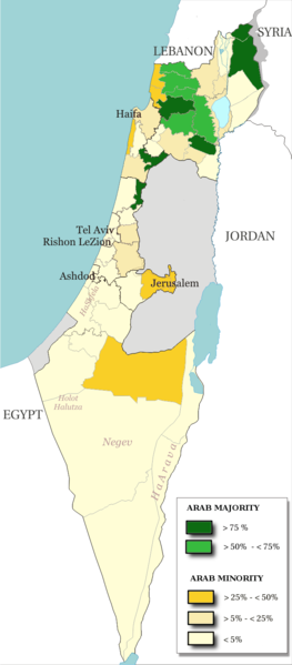
پەڕگە:Arab population israel 2000 en.png
ناوەڕۆکی پەڕە بە زمانەکانی تر پشتگیریی لێ ناکرێت.
لە ئینسایکڵۆپیدیای ئازادی ویکیپیدیاوە

پەڕگەی سەرەکی(٦٩٢ × ١٬٥٧٥ پیکسڵ، قەبارەی پەڕگە: ١٨٢ کیلۆبایت، جۆری ئێم ئای ئێم ئی: image/png)

ئەم پەڕگە لە Wikimedia Commonsەوەیە و لەوانەیە لە پڕۆژەکانی دیکەش بەکار ھاتبێت. پێناسەکەی لەسەر پەڕەی وەسفی پەڕگەکە لە خوارەوە نیشان دراوە.

کورتە

وەسف
English: Map of the officials 50 "natural regions" of Israel, with their proportions of arab population. The map includ the Golan heights and east Jerusalem, two areas annexed by Israel, annexions not recognize by UNO. The map is based on the demographic situation 2000, and is based upon the arab population in Israel [PDF], a publication (Statistilite N°27) of the israeli Center Bureau of Statistics (CBS) diffused in november 2002.
Français : Carte des 50 "régions naturelles" officiellement reconnues par l'état, subdivision des 15 sous-districts, avec la proportion de population arabe. Cette carte inclue Jérusalem-Est et le plateau du Golan, tous deux annexés par Israël, mais dont l'annexion n'est pas reconnue par l'ONU. La carte est basée sur la situation de la population en l'an 2000, et est inspirée de the arab population in Israel [PDF], une publication (Statistilite N°27) du Center Bureau of Statistics israélien (CBS) diffusée en novembre 2002.
ڕێکەوت
سەرچاوە Own work, derivative work of: File:Israel population density.png
بەرھەمھێنەر Christophe cagé
وەشانەکانی تر File:Arabe population israel 2000 fr.png

مۆڵەتنامە

© The copyright holder of this file, Israel Central Bureau of Statistics, allows anyone to use it for any purpose, provided that the copyright holder is properly attributed. Redistribution, derivative work, commercial use, and all other use is permitted.
دانەپاڵ:
The Central Bureau of Statistics (CBS), {{{filename}}}, ({{{access-date}}}), [{{{link}}} available online] copied and distributed as is in accordance with the CBS license.

{{{template}}} According to the CBS license, you may not make the following use of the Information, whether by positive act or by omission:
  • present the Information in a misleading manner;
  • present the Information in a way that suggests that the Central Bureau of Statistics, or the State of Israel, supports or endorses you or your use of the Information;
  • make use of the Information in a manner that breaches any applicable law;
  • make use of the Information in a manner that infringes a person's privacy, including merging the Information with other sources of information with the intent of attempting to identify any individual person, business or organization;
  • present the Information in such a manner that gives the appearance that you may have received, or had access to, information held by the Office about any identifiable individual person, business or organization.
من، ھەڵگری مافی لەبەرگرتنەوەی ئەم بەرھەمە، لەژێر ئەم مۆڵەتنامەیانەدا بڵاوی دەکەمەوە:
GNU head ڕێگەدراوە بە لەبەرگرتنەوە، دابەشکردن ھەروەھا/یان سازاندنی ئەم بەڵگەنامەیە لەژێر مەرجی مۆڵەتی GNU بۆ بەڵگەنامەی ئازاد، وەشانی ١.٢ یان ھەر وەشانێکی تری دواتر کە بڵاوکراوەتەوە لەلایەن دامەزراوەی بەرنامەی ئازاد، بەبێ ھیچ بەشێکی جیاواز، بەبێ نووسین لەسەر بەرگی پێشەوە و دواوەی. وێنەیەک لەمۆڵەتەکە لە بەشێکدا ھەیە کە ناوی مۆڵەتی GNU بۆ بەڵگەنامەی ئازادە.
w:en:Creative Commons
دانەپاڵ بڵاوکردنەوەی گونجاو
This file is licensed under the Creative Commons Attribution-Share Alike 3.0 Unported, 2.5 Generic, 2.0 Generic and 1.0 Generic license.
تۆ ئازادی:
  • بۆ بڵاکردنەوە – بۆ کۆپی کردن، دابەشکردن و دەستبەدەست ناردنی
  • بۆ تێکەڵکردنەوە – بۆ سازاندنی کارەکە
بەم مەرجانەی خوارەوە:
  • دانەپاڵ – پێویستە باوەڕی گونجاو بدەیت، بەستەرێک بۆ مۆڵەتەکە دابین بکەیت و ئاماژە بەوە بکەیت کە ئایا گۆڕانکاری کراوە یان نا. دەتوانیت بە هەر شێوەیەکی گونجاو ئەوە بکەیت، بەڵام بە شێوەیەک نا کە وا دەربکەوێت کە مۆڵەتدەر پشتگیری تۆ یان بەکارهێنانەکەت بکات.
  • بڵاوکردنەوەی گونجاو – ئەگەر لەسەر بنەمای ئەم کارە تێکەڵ، گۆڕان، یان ساز بکەی، پێویستە بەشدارییەکانت بە هەمان مۆڵەت یان هاوشێوەی مۆڵەتی ئەسڵی دابەش بکەی.
دەتوانی مۆڵەتنامەی دڵخوازت ھەڵبژێریت.

لێدوانەکان

Add a one-line explanation of what this file represents

بەندەکانی لەم پەڕگەیەدا دەردەکەون

depicts ئینگلیزی

٢٢ شوباتی 2009

media type ئینگلیزی

image/png

checksum ئینگلیزی

5afc0b91dfe8d983a85af862f3a58ec981a8a743

determination method ئینگلیزی: SHA-1 ئینگلیزی

data size ئینگلیزی

١٨٦٬١٣٨ بایت

١٬٥٧٥ پیکسڵ

width ئینگلیزی

٦٩٢ پیکسڵ

مێژووی پەڕگە

کرتە بکە لەسەر یەکێک لە ڕێکەوت/کاتەکان بۆ بینینی پەڕگەکە بەو شێوەی لەو کاتەدا بووە.

ڕێکەوت/کاتھێمائەندازەبەکارھێنەرتێبینی
هەنووکە‏١٣:٤٨، ١٥ی تەممووزی ٢٠١٤ھێما بۆ وەشانی  ‏١٣:٤٨، ١٥ی تەممووزی ٢٠١٤٦٩٢ لە ١٬٥٧٥ (١٨٢ کیلۆبایت)Hruska~commonswikiReverted to version as of 08:23, 22 February 2009
‏١٣:٤٧، ١٥ی تەممووزی ٢٠١٤ھێما بۆ وەشانی  ‏١٣:٤٧، ١٥ی تەممووزی ٢٠١٤٦٩٢ لە ١٬٥٧٥ (١٨٢ کیلۆبایت)Hruska~commonswikiReverted to version as of 08:23, 22 February 2009 Revert Edit, The Golan and East Jerusalem de facto Israel, Syria giving Status qo
‏١٣:٤٦، ١٥ی تەممووزی ٢٠١٤ھێما بۆ وەشانی  ‏١٣:٤٦، ١٥ی تەممووزی ٢٠١٤٦٩٢ لە ١٬٥٧٥ (١٨٢ کیلۆبایت)Hruska~commonswikiReverted to version as of 08:23, 22 February 2009
‏١٥:٣٨، ٢١ی نیسانی ٢٠٠٩ھێما بۆ وەشانی  ‏١٥:٣٨، ٢١ی نیسانی ٢٠٠٩٦٩٢ لە ١٬٥٧٥ (١٦٥ کیلۆبایت)MeteorMaker~commonswiki{{Information |Description={{en|1=Map of the officials 50 "natural regions" of Israel, with their proportions of arab population. The map includ the Golan heights and east Jerusalem, two areas annexed by Israel, annexions not recognize by UNO. The map is
‏٠٨:٢٣، ٢٢ی شوباتی ٢٠٠٩ھێما بۆ وەشانی  ‏٠٨:٢٣، ٢٢ی شوباتی ٢٠٠٩٦٩٢ لە ١٬٥٧٥ (١٨٢ کیلۆبایت)Christophe cagé{{Information |Description={{en|1=x}} {{fr|1=x}} |Source=travail personnel (own work) |Author=Christophe cagé |Date=22 february 2009 |Permission=SEE LICENSE |other_versions= }} <!--{{ImageUpload|full}}-->

ئەم پەڕەیە ئەم پەڕگەیە بەکار دەھێنێت:

بەکارھێنانی سەرانسەریی پەڕگە

ئەم ویکیانەی دیکەی خوارەوەش ئەم پەڕگە بەکاردێنن:

دراوی مێتا