
پەڕگە:Yom Kippur War map.svg

Size of this PNG preview of this SVG file: ٣٩٨ لە ٥٩٩ پیکسەڵ. ڕێزەلووشنەکانی تر: ١٥٩ لە ٢٤٠ پیکسەڵ | ٣١٩ لە ٤٨٠ پیکسەڵ | ٥١٠ لە ٧٦٨ پیکسەڵ | ٦٨٠ لە ١٬٠٢٤ پیکسەڵ | ١٬٣٦١ لە ٢٬٠٤٨ پیکسەڵ | ٤٠٠ لە ٦٠٢ پیکسەڵ.
پەڕگەی سەرەکی (پەڕگەی SVG، بە ناو ٤٠٠ × ٦٠٢ پیکسەڵ، قەبارەی پەڕگە: ٤٣ کیلۆبایت)
کورتە
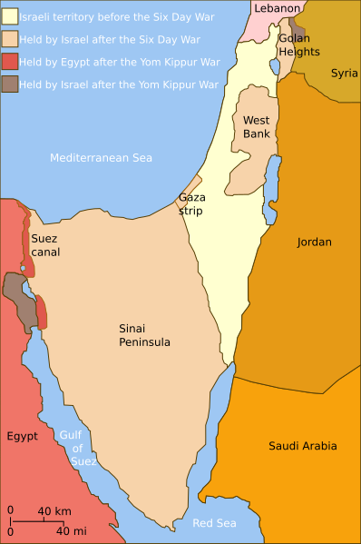
| وەسف | Self-made line drawing of a map of Israel's territories before and after the Yom Kippur War. |
| ڕێکەوت | |
| سەرچاوە | Source of line drawing: Now-deleted image Jom kippur war.jpg which was originally uploaded to the polish Wikipedia at Jom kippur war.jpg -- Ministerstwo Spraw Zagranicznych Izraela, za zgodÄ… Ambasady Izraela w Polsce. -- Ministry of Foreign Affairs of Israel, with the permission of Israel Embassy in Poland |
| بەرھەمھێنەر | Raul654 |
| وەشانەکانی تر |
[]
|
| SVG genesis |


|
This SVG file contains embedded text that can be translated into your language, using any capable SVG editor, text editor or the SVG Translate tool. For more information see: About translating SVG files. |
مۆڵەتنامە
This file is licensed under the Creative Commons Attribution-Share Alike 2.5 Generic license.
- تۆ ئازادی:
- بۆ بڵاکردنەوە – بۆ کۆپی کردن، دابەشکردن و دەستبەدەست ناردنی
- بۆ تێکەڵکردنەوە – بۆ سازاندنی کارەکە
- بەم مەرجانەی خوارەوە:
- دانەپاڵ – پێویستە باوەڕی گونجاو بدەیت، بەستەرێک بۆ مۆڵەتەکە دابین بکەیت و ئاماژە بەوە بکەیت کە ئایا گۆڕانکاری کراوە یان نا. دەتوانیت بە هەر شێوەیەکی گونجاو ئەوە بکەیت، بەڵام بە شێوەیەک نا کە وا دەربکەوێت کە مۆڵەتدەر پشتگیری تۆ یان بەکارهێنانەکەت بکات.
- بڵاوکردنەوەی گونجاو – ئەگەر لەسەر بنەمای ئەم کارە تێکەڵ، گۆڕان، یان ساز بکەی، پێویستە بەشدارییەکانت بە هەمان مۆڵەت یان هاوشێوەی مۆڵەتی ئەسڵی دابەش بکەی.
مێژووی پەڕگە
کرتە بکە لەسەر یەکێک لە ڕێکەوت/کاتەکان بۆ بینینی پەڕگەکە بەو شێوەی لەو کاتەدا بووە.
| ڕێکەوت/کات | ھێما | ئەندازە | بەکارھێنەر | تێبینی | |
|---|---|---|---|---|---|
| هەنووکە | ١٤:٣٥، ٣ی تەممووزی ٢٠١٠ | | ٤٠٠ لە ٦٠٢ (٤٣ کیلۆبایت) | ChrisO | |
| ١٢:٥٢، ٢٠ی شوباتی ٢٠١٠ |  | ٤٠٠ لە ٦٠٢ (٤٣ کیلۆبایت) | Hohum | Added border lines. | |
| ١٣:٤٢، ٣١ی ئایاری ٢٠٠٩ |  | ٤٠٠ لە ٦٠٢ (٤٦ کیلۆبایت) | Hohum | Fixed Golan Heights colour. | |
| ١٣:٣٩، ٣١ی ئایاری ٢٠٠٩ |  | ٤٠٠ لە ٦٠٢ (٤٦ کیلۆبایت) | Hohum | Adjusted colours to be less garish, more map-like. | |
| ١١:٣٢، ٩ی نیسانی ٢٠٠٩ |  | ٤٠٠ لە ٦٠٢ (٤٥ کیلۆبایت) | Kordas | colours fixed | |
| ٢٣:٢٣، ١٥ی ئایاری ٢٠٠٨ |  | ٤٠٠ لە ٦٠٢ (٤٦ کیلۆبایت) | Kordas | Updated version (Added "West Bank" and seas names' in white) | |
| ٠٤:١١، ٣ی تشرینی یەکەمی ٢٠٠٧ |  | ٤٠٠ لە ٦٠٢ (٤٦ کیلۆبایت) | Andrew Hampe | Removed line referencing external jpeg image. | |
| ٠٣:٥٨، ٣ی تشرینی یەکەمی ٢٠٠٧ |  | ٤٠٠ لە ٦٠٢ (٤٥ کیلۆبایت) | Raul654 | Standard svg | |
| ٠٣:٥٥، ٣ی تشرینی یەکەمی ٢٠٠٧ |  | ٤٠٠ لە ٦٠٢ (٤٥ کیلۆبایت) | Raul654 | Self-made line drawing of a map of Israel's territories before and after the Yom Kippur War. Source of line drawing: Now-deleted image Image:Jom kippur war.jpg {{cc-by-sa}} |
بەکارھێنانی پەڕگە
ئەم پەڕەی 3ە ئەم پەڕگەیە بەکار دەھێنێت:
بەکارھێنانی سەرانسەریی پەڕگە
ئەم ویکیانەی دیکەی خوارەوەش ئەم پەڕگە بەکاردێنن:
- بەکارھێنان لە ar.wikipedia.org
- بەکارھێنان لە ca.wikipedia.org
- بەکارھێنان لە en.wikipedia.org
- بەکارھێنان لە fa.wikipedia.org
- بەکارھێنان لە fr.wikipedia.org
- بەکارھێنان لە fr.wikiversity.org
- بەکارھێنان لە he.wikipedia.org
- بەکارھێنان لە hy.wikipedia.org
- بەکارھێنان لە id.wikipedia.org
- بەکارھێنان لە it.wikipedia.org
- بەکارھێنان لە ja.wikipedia.org
- بەکارھێنان لە jv.wikipedia.org
- بەکارھێنان لە mzn.wikipedia.org
- بەکارھێنان لە no.wikipedia.org
- بەکارھێنان لە pt.wikipedia.org
- بەکارھێنان لە ro.wikipedia.org
- بەکارھێنان لە sh.wikipedia.org
- بەکارھێنان لە tg.wikipedia.org
- بەکارھێنان لە www.wikidata.org
- بەکارھێنان لە zh.wikipedia.org