
پەڕگە:Un-guatemala.png
پەڕگەی سەرەکی (٢٬٤٩٣ × ٢٬٩٤٧ پیکسڵ، قەبارەی پەڕگە: ١٫٨ مێگابایت، جۆری ئێم ئای ئێم ئی: image/png)
| This image is a map derived from a United Nations map.
Unless stated otherwise, UN maps are to be considered in the public domain. This applies worldwide. UN maps are, in principle, open source material and you can use them in your work or for making your own map. UN requests however that you delete the UN name, logo and reference number upon any modification to the map. Content of your map will be your responsibility. You can state in your publication, if you wish, something like: based on UN map … (map name, map number, revision number and date). See: Geospatial Information Section. And: Geospatial, location data for a better world. |
 |
| وەسف |
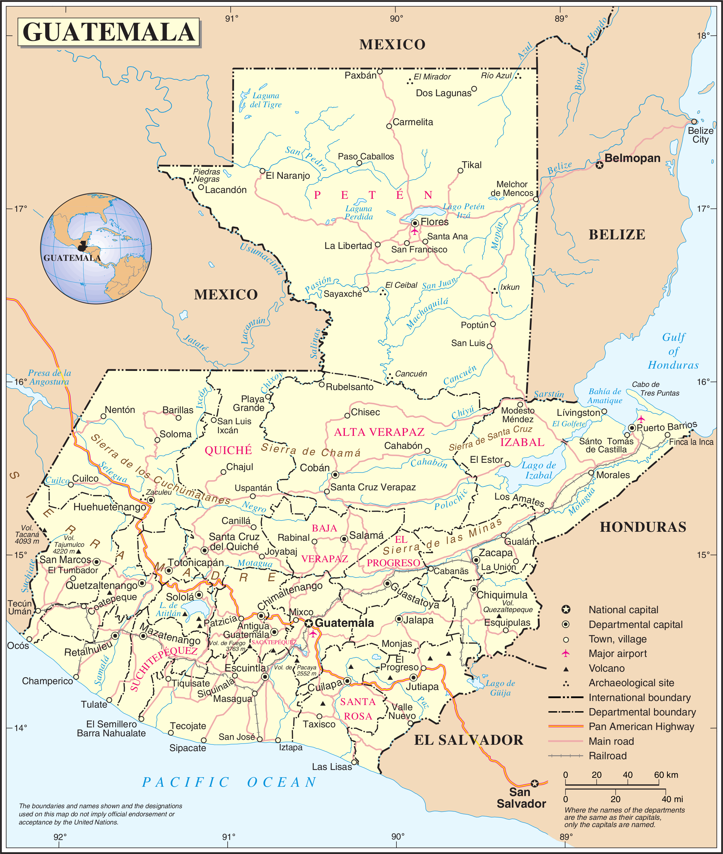
English: Political map of Guatemala generated by the United Nations. |
| ڕێکەوت | |
| سەرچاوە | United Nations Geospatial Information Section |
| بەرھەمھێنەر | United Nations Department of Peacekeeping Operations Cartographic Section |
مێژووی پەڕگە
کرتە بکە لەسەر یەکێک لە ڕێکەوت/کاتەکان بۆ بینینی پەڕگەکە بەو شێوەی لەو کاتەدا بووە.
| ڕێکەوت/کات | ھێما | ئەندازە | بەکارھێنەر | تێبینی | |
|---|---|---|---|---|---|
| هەنووکە | ٠١:٠٤، ٢٤ی تشرینی یەکەمی ٢٠٠٧ | | ٢٬٤٩٣ لە ٢٬٩٤٧ (١٫٨ مێگابایت) | Jeroen | {{UN map}} Category:Maps of Guatemala |
بەکارھێنانی پەڕگە
ئەم پەڕەیە ئەم پەڕگەیە بەکار دەھێنێت:
بەکارھێنانی سەرانسەریی پەڕگە
ئەم ویکیانەی دیکەی خوارەوەش ئەم پەڕگە بەکاردێنن:
- بەکارھێنان لە af.wikipedia.org
- بەکارھێنان لە ar.wikipedia.org
- بەکارھێنان لە be-tarask.wikipedia.org
- بەکارھێنان لە el.wikipedia.org
- بەکارھێنان لە en.wikipedia.org
- Geography of Guatemala
- List of places in Guatemala
- Carlos Castillo Armas
- 1954 Guatemalan coup d'état
- Water supply and sanitation in Guatemala
- Outline of Guatemala
- Guatemala
- List of rivers of Guatemala
- Index of Guatemala-related articles
- Water resources management in Guatemala
- United Nations Security Council Resolution 1094
- User:Nlyemica/sandbox
- بەکارھێنان لە es.wikipedia.org
- بەکارھێنان لە fa.wikipedia.org
- بەکارھێنان لە fi.wikipedia.org
- بەکارھێنان لە gom.wikipedia.org
- بەکارھێنان لە id.wikipedia.org
- بەکارھێنان لە kbp.wikipedia.org
- بەکارھێنان لە kn.wikipedia.org
- بەکارھێنان لە lez.wikipedia.org
- بەکارھێنان لە mzn.wikipedia.org
- بەکارھێنان لە nl.wikipedia.org
- بەکارھێنان لە pl.wiktionary.org
- بەکارھێنان لە ro.wikipedia.org
- بەکارھێنان لە ru.wikipedia.org
- بەکارھێنان لە sl.wikipedia.org
- بەکارھێنان لە ta.wikipedia.org
- بەکارھێنان لە te.wikipedia.org
- بەکارھێنان لە to.wikipedia.org
- بەکارھێنان لە uk.wikipedia.org
- بەکارھێنان لە uk.wiktionary.org
- بەکارھێنان لە www.wikidata.org
بینینی بەکارھێنانی گشتی زیاتری ئەم پەڕگەیە.