
پەڕگە:USA Map 1864 including Civil War Divisions.png
رەزۆلوشنی سەرتر لەمە لە بەردەست دا نیە.
USA_Map_1864_including_Civil_War_Divisions.png (٧٨٤ × ٤٨٨ پیکسڵ، قەبارەی پەڕگە: ٢٥ کیلۆبایت، جۆری ئێم ئای ئێم ئی: image/png)
کورتە

|
This locator map image could be re-created using vector graphics as an SVG file. This has several advantages; see Commons:Media for cleanup for more information. If an SVG form of this image is available, please upload it and afterwards replace this template with
{{vector version available|new image name}}.
It is recommended to name the SVG file “USA Map 1864 including Civil War Divisions.svg”—then the template Vector version available (or Vva) does not need the new image name parameter. |
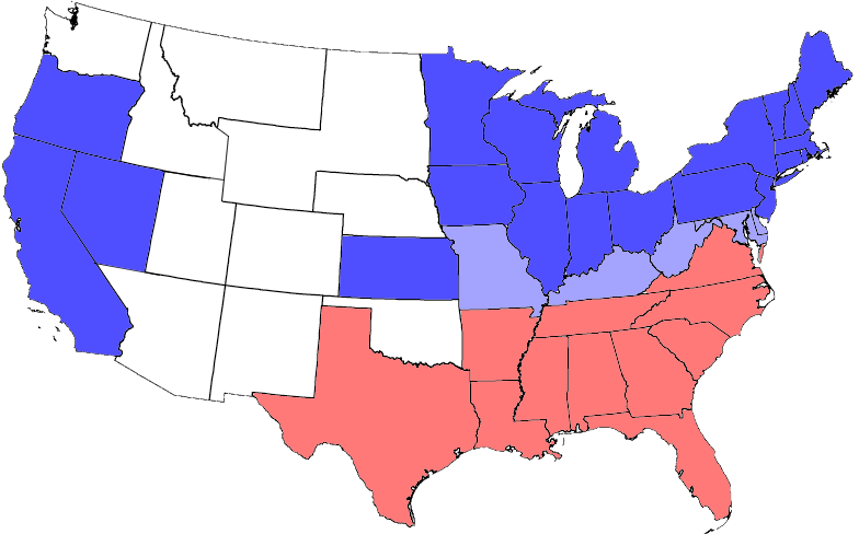
from one on Wikipedia. All blue areas represent Union states, including those admitted during the war; light blue areas represent Union states which permitted slavery; red areas represent Confederate states.
Note: West Virginia became a state during the Civil War
مۆڵەتنامە
من، ھەڵگری مافی لەبەرگرتنەوەی ئەم بەرھەمە، لەژێر ئەم مۆڵەتنامەیانەدا بڵاوی دەکەمەوە:

|
ڕێگەدراوە بە لەبەرگرتنەوە، دابەشکردن ھەروەھا/یان سازاندنی ئەم بەڵگەنامەیە لەژێر مەرجی مۆڵەتی GNU بۆ بەڵگەنامەی ئازاد، وەشانی ١.٢ یان ھەر وەشانێکی تری دواتر کە بڵاوکراوەتەوە لەلایەن دامەزراوەی بەرنامەی ئازاد، بەبێ ھیچ بەشێکی جیاواز، بەبێ نووسین لەسەر بەرگی پێشەوە و دواوەی. وێنەیەک لەمۆڵەتەکە لە بەشێکدا ھەیە کە ناوی مۆڵەتی GNU بۆ بەڵگەنامەی ئازادە. |
| ئەم پەڕگەیە لە ژێر مۆڵەتنامەی | ||
| ||
| This licensing tag was added to this file as part of the GFDL licensing update. |
دەتوانی مۆڵەتنامەی دڵخوازت ھەڵبژێریت.
مێژووی پەڕگە
کرتە بکە لەسەر یەکێک لە ڕێکەوت/کاتەکان بۆ بینینی پەڕگەکە بەو شێوەی لەو کاتەدا بووە.
| ڕێکەوت/کات | ھێما | ئەندازە | بەکارھێنەر | تێبینی | |
|---|---|---|---|---|---|
| هەنووکە | ٢٠:١٤، ٣ی تەممووزی ٢٠٠٦ | | ٧٨٤ لە ٤٨٨ (٢٥ کیلۆبایت) | Tom | adjusting colors and formatting |
| ٠٤:١٢، ٢٤ی ئابی ٢٠٠٥ |  | ٨١٢ لە ٥٠٣ (٣٤ کیلۆبایت) | Tom | {{GFDL}} United States Civil War Division in 1864 - slightly modified from one on Wikipedia. |
بەکارھێنانی پەڕگە
ئەم پەڕەیە ئەم پەڕگەیە بەکار دەھێنێت:
بەکارھێنانی سەرانسەریی پەڕگە
ئەم ویکیانەی دیکەی خوارەوەش ئەم پەڕگە بەکاردێنن:
- بەکارھێنان لە als.wikipedia.org
- بەکارھێنان لە az.wikipedia.org
- بەکارھێنان لە be.wikipedia.org
- بەکارھێنان لە bg.wikipedia.org
- بەکارھێنان لە br.wikipedia.org
- بەکارھێنان لە ca.wikipedia.org
- بەکارھێنان لە co.wikipedia.org
- بەکارھێنان لە da.wikipedia.org
- بەکارھێنان لە de.wikipedia.org
- Sezessionskrieg
- Südstaaten
- Benutzer:Ralf Reinartz/Vorlagen
- Wikipedia:Bücher/Geschichte der USA: Bürgerkrieg und Reconstruction
- Postgeschichte und Briefmarken der Vereinigten Staaten
- Wikipedia Diskussion:Hauptseite/Artikel des Tages/Archiv/Vorschläge/2014/Q1
- Wikipedia:Hauptseite/Archiv/2. Januar 2014
- Benutzer:LDV-E8
- بەکارھێنان لە de.wikiversity.org
- بەکارھێنان لە el.wikipedia.org
- بەکارھێنان لە en.wikipedia.org
- بەکارھێنان لە en.wiktionary.org
- بەکارھێنان لە es.wikipedia.org
- بەکارھێنان لە et.wikipedia.org
- بەکارھێنان لە fa.wikipedia.org
- بەکارھێنان لە frr.wikipedia.org
- بەکارھێنان لە fr.wikipedia.org
- بەکارھێنان لە he.wikipedia.org
- بەکارھێنان لە hr.wikipedia.org
- بەکارھێنان لە hu.wikipedia.org
- بەکارھێنان لە incubator.wikimedia.org
- بەکارھێنان لە ja.wikipedia.org
- بەکارھێنان لە ko.wikipedia.org
- بەکارھێنان لە ku.wikipedia.org
بینینی بەکارھێنانی گشتی زیاتری ئەم پەڕگەیە.