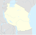
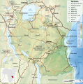
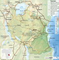
پەڕگە:Tanzania location map.svg

ناوەڕۆکی پەڕە بە زمانەکانی تر پشتگیریی لێ ناکرێت.
لە ئینسایکڵۆپیدیای ئازادی ویکیپیدیاوە

پەڕگەی سەرەکی(پەڕگەی SVG، بە ناو ٣٬٣٠٢ × ٣٬١٤٣ پیکسەڵ، قەبارەی پەڕگە: ١٫٠٤ مێگابایت)

ئەم پەڕگە لە Wikimedia Commonsەوەیە و لەوانەیە لە پڕۆژەکانی دیکەش بەکار ھاتبێت. پێناسەکەی لەسەر پەڕەی وەسفی پەڕگەکە لە خوارەوە نیشان دراوە.

کورتە

وەسف
Afrikaans: Liggingkaart van Tanzanië
English: Location map of Tanzania
Español: Mapa de georreferenciación de Tanzania
Français : Carte de géolocalisation de la Tanzanie
Equirectangular projection. 0.25° N, 28° W, 42° E, -13° S. Center : -6.375 35
ڕێکەوت (UTC)
سەرچاوە
بەرھەمھێنەر
وەشانەکانی تر

Derivative works of this file:  Iringa Regionen.png [دەستکاری]

دانەپاڵ
(required by the license)
InfoField
© Sémhur / Wikimedia Commons / 
© Sémhur / Wikimedia Commons
SVG
InfoField
 
W3C-validity not checked.
 
This W3C-unspecified vector image was created with Inkscape…important .
This is a retouched picture, which means that it has been digitally altered from its original version. Modifications: Cropped, and prepared for geolocation.. The original can be viewed here: Tanzania map-fr.svg. Modifications made by Sémhur.

Graphic Lab
InfoField
Object location٦° ٢٢′ ٣٠″ S, ٣٥° ٠٠′ ٠٠″ E  Heading=1° Kartographer map based on OpenStreetMap.View this and other nearby images on: OpenStreetMapinfo

مۆڵەتنامە

من، ھەڵگری مافی لەبەرگرتنەوەی ئەم بەرھەمە، لەژێر ئەم مۆڵەتنامەیانەدا بڵاوی دەکەمەوە:
w:en:Creative Commons
دانەپاڵ بڵاوکردنەوەی گونجاو
This file is licensed under the Creative Commons Attribution-Share Alike 4.0 International, 3.0 Unported, 2.5 Generic, 2.0 Generic and 1.0 Generic license.
تۆ ئازادی:
  • بۆ بڵاکردنەوە – بۆ کۆپی کردن، دابەشکردن و دەستبەدەست ناردنی
  • بۆ تێکەڵکردنەوە – بۆ سازاندنی کارەکە
بەم مەرجانەی خوارەوە:
  • دانەپاڵ – پێویستە باوەڕی گونجاو بدەیت، بەستەرێک بۆ مۆڵەتەکە دابین بکەیت و ئاماژە بەوە بکەیت کە ئایا گۆڕانکاری کراوە یان نا. دەتوانیت بە هەر شێوەیەکی گونجاو ئەوە بکەیت، بەڵام بە شێوەیەک نا کە وا دەربکەوێت کە مۆڵەتدەر پشتگیری تۆ یان بەکارهێنانەکەت بکات.
  • بڵاوکردنەوەی گونجاو – ئەگەر لەسەر بنەمای ئەم کارە تێکەڵ، گۆڕان، یان ساز بکەی، پێویستە بەشدارییەکانت بە هەمان مۆڵەت یان هاوشێوەی مۆڵەتی ئەسڵی دابەش بکەی.
Licence Art Libre Copyleft: This work of art is free; you can redistribute it and/or modify it according to terms of the Free Art License. You will find a specimen of this license on the Copyleft Attitude site as well as on other sites.
دەتوانی مۆڵەتنامەی دڵخوازت ھەڵبژێریت.

Original upload log

This image is a derivative work of the following images:

  • File:Tanzania_map-fr.svg licensed with Cc-by-sa-3.0,2.5,2.0,1.0, GFDL
    • 2009-03-20T13:30:18Z Sémhur 3096x3113 (3225659 Bytes) Ol Doinyo Lengaï was misplaced
    • 2009-03-20T11:14:35Z Sémhur 3096x3113 (3224368 Bytes) Add location map and few summits.
    • 2009-03-19T17:14:13Z Sémhur 3096x3113 (3099209 Bytes) grrr...
    • 2009-03-19T17:08:18Z Sémhur 3096x3113 (3099244 Bytes) Oups ! It wasn't the valid one.
    • 2009-03-19T17:05:02Z Sémhur 3096x3113 (3122421 Bytes) {{Information |Description={{en|1=Map of [[:en:Tanzania]].}} {{fr|1=Carte de la [[:fr:Tanzanie]].}} {{es|1=Mapa de [[:es:Tanzania]].}} |Source=travail personnel (own work). Sources of data: * Elevations : NASA SRTM3 (public d

Uploaded with derivativeFX

Original upload log

date/time username resolution size edit summary
2009-05-03T08:48:31Z User:Sémhur 3096×2947 828.71Kb borders above waters
2009-05-03T08:45:18Z User:Sémhur 3096×2947 828.72Kb Adding border between Arusha and Manyara
2009-05-01T18:46:42Z User:Sémhur 3096×2947 822.6Kb {{int:summary}} {{Information |Description={{en|1=Location map of [[:en:Tanzania]].}} {{fr|1=Carte de géolocalisation de la [[:fr:Tanzanie]].}} {{es|1=Mapa de georreferenciación de [[:es:Tanzania]].}} Equirectangular projection. 0.25° N, 28° W, 42°

لێدوانەکان

Add a one-line explanation of what this file represents
Location map of Tanzania

بەندەکانی لەم پەڕگەیەدا دەردەکەون

depicts ئینگلیزی

١ ئایاری 2009

6°S, 35°E

heading ئینگلیزی: ١ پلە

MIME type ئینگلیزی

image/svg+xml

مێژووی پەڕگە

کرتە بکە لەسەر یەکێک لە ڕێکەوت/کاتەکان بۆ بینینی پەڕگەکە بەو شێوەی لەو کاتەدا بووە.

ڕێکەوت/کاتھێمائەندازەبەکارھێنەرتێبینی
هەنووکە‏٢٠:١٥، ٢٥ی ئایاری ٢٠١٧ھێما بۆ وەشانی  ‏٢٠:١٥، ٢٥ی ئایاری ٢٠١٧٣٬٣٠٢ لە ٣٬١٤٣ (١٫٠٤ مێگابایت)SémhurUpdated with Songwe Region
‏١٤:١٦، ١٣ی کانوونی یەکەمی ٢٠١٣ھێما بۆ وەشانی  ‏١٤:١٦، ١٣ی کانوونی یەکەمی ٢٠١٣٣٬٠٩٦ لە ٢٬٩٤٧ (١٫٠٣ مێگابایت)SémhurUpdated with the four new regions
‏٠٠:٣٠، ٢٥ی تەممووزی ٢٠٠٩ھێما بۆ وەشانی  ‏٠٠:٣٠، ٢٥ی تەممووزی ٢٠٠٩٣٬٠٩٦ لە ٢٬٩٤٧ (٨٢٩ کیلۆبایت)BetacommandBotmove approved by: User:Sémhur This image was moved from File:Tanzania location equirectangular map.svg =={{int:summary}}== {{Information |Description={{en|1=Location map of en:Tanzania.}} {{fr|1=Carte de géolocalisation de la [[:fr:Tanz

ئەم پەڕەیە ئەم پەڕگەیە بەکار دەھێنێت:

بەکارھێنانی سەرانسەریی پەڕگە

ئەم ویکیانەی دیکەی خوارەوەش ئەم پەڕگە بەکاردێنن:

بینینی بەکارھێنانی گشتی زیاتری ئەم پەڕگەیە.

دراوی مێتا