پەڕگە:Taiwan relief location map.jpg

ناوەڕۆکی پەڕە بە زمانەکانی تر پشتگیریی لێ ناکرێت.
لە ئینسایکڵۆپیدیای ئازادی ویکیپیدیاوە

پەڕگەی سەرەکی(١٬٠١٦ × ١٬٢٢٢ پیکسڵ، قەبارەی پەڕگە: ١٠١ کیلۆبایت، جۆری ئێم ئای ئێم ئی: image/jpeg)

ئەم پەڕگە لە Wikimedia Commonsەوەیە و لەوانەیە لە پڕۆژەکانی دیکەش بەکار ھاتبێت. پێناسەکەی لەسەر پەڕەی وەسفی پەڕگەکە لە خوارەوە نیشان دراوە.

Warning sign This file requires updating because: The earlier forms of this map did not extend a dotted-line around Dongyin, Lienchiang (Tungyin). The northern edge of this map ought to be moved up a little bit (in latitude) so that a dotted line encompassing Dongyin (Tungyin) can be clearly drawn and so that we can see a few of the islands north of Lienchiang County in Haidao Township, PRC. Example of a better map from The Economist: [1]. In doing so, you could add a timestamp to the file.
Please notify the uploader with {{subst:update-note|1=File:Taiwan relief location map.jpg|2=The earlier forms of this map did not extend a dotted-line around Dongyin, Lienchiang (Tungyin). The northern edge of this map ought to be moved up a little bit (in latitude) so that a dotted line encompassing Dongyin (Tungyin) can be clearly drawn and so that we can see a few of the islands north of Lienchiang County in Haidao Township, PRC. Example of a better map from The Economist: [2].}} ~~~~

کورتە

وەسف
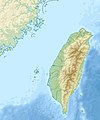
English: Relief location map of Taiwan.
  • Projection: Equirectangular projection, strechted by 110.0%.
  • Geographic limits of the map:
  • N: 26.4° N
  • S: 21.7° N
  • W: 118.0° E
  • E: 122.3° E
  • GMT projection: -JX17.204266666666665cd/20.68512992248063cd
  • GMT region: -R118.0/21.7/122.3/26.4r
  • GMT region for grdcut: -R118.0/21.7/122.3/26.4r
  • Relief: SRTM30plus.
  • Made with Natural Earth. Free vector and raster map data @ naturalearthdata.com.
ڕێکەوت
سەرچاوە بەرھەمی خۆم
بەرھەمھێنەر Uwe Dedering

مۆڵەتنامە

من، ھەڵگری مافی لەبەرگرتنەوەی ئەم بەرھەمە، لەژێر ئەم مۆڵەتنامەیانەدا بڵاوی دەکەمەوە:
w:en:Creative Commons
دانەپاڵ بڵاوکردنەوەی گونجاو
This file is licensed under the Creative Commons Attribution-Share Alike 3.0 Unported, 2.5 Generic, 2.0 Generic and 1.0 Generic license.
تۆ ئازادی:
  • بۆ بڵاکردنەوە – بۆ کۆپی کردن، دابەشکردن و دەستبەدەست ناردنی
  • بۆ تێکەڵکردنەوە – بۆ سازاندنی کارەکە
بەم مەرجانەی خوارەوە:
  • دانەپاڵ – پێویستە باوەڕی گونجاو بدەیت، بەستەرێک بۆ مۆڵەتەکە دابین بکەیت و ئاماژە بەوە بکەیت کە ئایا گۆڕانکاری کراوە یان نا. دەتوانیت بە هەر شێوەیەکی گونجاو ئەوە بکەیت، بەڵام بە شێوەیەک نا کە وا دەربکەوێت کە مۆڵەتدەر پشتگیری تۆ یان بەکارهێنانەکەت بکات.
  • بڵاوکردنەوەی گونجاو – ئەگەر لەسەر بنەمای ئەم کارە تێکەڵ، گۆڕان، یان ساز بکەی، پێویستە بەشدارییەکانت بە هەمان مۆڵەت یان هاوشێوەی مۆڵەتی ئەسڵی دابەش بکەی.
GNU head ڕێگەدراوە بە لەبەرگرتنەوە، دابەشکردن ھەروەھا/یان سازاندنی ئەم بەڵگەنامەیە لەژێر مەرجی مۆڵەتی GNU بۆ بەڵگەنامەی ئازاد، وەشانی ١.٢ یان ھەر وەشانێکی تری دواتر کە بڵاوکراوەتەوە لەلایەن دامەزراوەی بەرنامەی ئازاد، بەبێ ھیچ بەشێکی جیاواز، بەبێ نووسین لەسەر بەرگی پێشەوە و دواوەی. وێنەیەک لەمۆڵەتەکە لە بەشێکدا ھەیە کە ناوی مۆڵەتی GNU بۆ بەڵگەنامەی ئازادە.
دەتوانی مۆڵەتنامەی دڵخوازت ھەڵبژێریت.

لێدوانەکان

Add a one-line explanation of what this file represents

بەندەکانی لەم پەڕگەیەدا دەردەکەون

depicts ئینگلیزی

source of file ئینگلیزی

٢٨ کانوونی یەکەمی 2010

MIME type ئینگلیزی

image/jpeg

مێژووی پەڕگە

کرتە بکە لەسەر یەکێک لە ڕێکەوت/کاتەکان بۆ بینینی پەڕگەکە بەو شێوەی لەو کاتەدا بووە.

ڕێکەوت/کاتھێمائەندازەبەکارھێنەرتێبینی
هەنووکە‏١٤:٠١، ١٩ی ئەیلوولی ٢٠١٩ھێما بۆ وەشانی  ‏١٤:٠١، ١٩ی ئەیلوولی ٢٠١٩١٬٠١٦ لە ١٬٢٢٢ (١٠١ کیلۆبایت)Geographyinitiativetemporary fix: extending the boundary out around Dongyin Township (as in China Fujian2 location map.svg and as in File:Nationalist China - administrative divisons. LOC 2007633622.jpg)
‏١٧:٠٩، ٣ی ئابی ٢٠١٩ھێما بۆ وەشانی  ‏١٧:٠٩، ٣ی ئابی ٢٠١٩١٬٠١٦ لە ١٬٢٢٢ (٥٣٧ کیلۆبایت)NordNordWestborder corrections
‏٠١:٥١، ٣ی ئابی ٢٠١٩ھێما بۆ وەشانی  ‏٠١:٥١، ٣ی ئابی ٢٠١٩١٬٠١٦ لە ١٬٢٢٢ (٩٦ کیلۆبایت)GeographyinitiativeProposed removal of three dashes (markers of the approximate PRC/ROC maritime boundary) which seemed to put Dadan Island, Erdan Island and Binlang Islet (檳榔嶼) outside the territory of Kinmen County, Taiwan/ROC. This is not the optimal form of the map, but is merely a quick removal of incorrect information. In the optimal situation, the line needs to be redrawn in the correct location, but I don't have the technical skill to produce such a map. (Basis: [http://ws.mac.gov.tw/001/Upload/OldFile/...
‏٠٠:٣٠، ٣ی ئابی ٢٠١٩ھێما بۆ وەشانی  ‏٠٠:٣٠، ٣ی ئابی ٢٠١٩١٬٠١٦ لە ١٬٢٢٢ (٩٦ کیلۆبایت)GeographyinitiativeProposed removal of two dashes (markers of the approximate PRC/ROC maritime boundary) which seemed to put {{w|Dadan Island}} and {{w|Erdan Island}} outside the territory of {{w|Kinmen County}}, Taiwan/ROC.
‏١٧:٢٢، ٢٨ی کانوونی یەکەمی ٢٠١٠ھێما بۆ وەشانی  ‏١٧:٢٢، ٢٨ی کانوونی یەکەمی ٢٠١٠١٬٠١٦ لە ١٬٢٢٢ (٤٥٢ کیلۆبایت)Uwe Dedering{{Information |Description={{en|1=Relief location map of Taiwan. * Projection: Equirectangular projection, strechted by 110.0%. * Geographic limits of the map: :* N: 26.4° N :* S: 21.7° N :* W: 118.0° E :* E: 122.3° E * GMT projection: -JX17.204266666

ئەم پەڕەیە ئەم پەڕگەیە بەکار دەھێنێت:

بەکارھێنانی سەرانسەریی پەڕگە

ئەم ویکیانەی دیکەی خوارەوەش ئەم پەڕگە بەکاردێنن:

بینینی بەکارھێنانی گشتی زیاتری ئەم پەڕگەیە.

دراوی مێتا