
پەڕگە:Soil erosion at Hill Farm - geograph.org.uk - 1287527.jpg
رەزۆلوشنی سەرتر لەمە لە بەردەست دا نیە.
Soil_erosion_at_Hill_Farm_-_geograph.org.uk_-_1287527.jpg (٦٤٠ × ٤٨٠ پیکسڵ، قەبارەی پەڕگە: ١٣٥ کیلۆبایت، جۆری ئێم ئای ئێم ئی: image/jpeg)
کورتە
| وەسف |
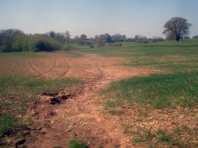
English: Soil erosion at Hill Farm Looking west at the bottom of a shallow valley which obviously becomes a water course in times of heavy rain. Most of the crop will be fine, but in the lower wetter areas growth is stunted and in the water course there is no growth at all. |
| ڕێکەوت | |
| سەرچاوە | From geograph.org.uk |
| بەرھەمھێنەر | Trevor Rickard |
| دانەپاڵ (required by the license) | Trevor Rickard / Soil erosion at Hill Farm / |
| Camera location | | View this and other nearby images on: OpenStreetMap |
|---|
_heading:270.00&language=ckb)
| Object location | | View this and other nearby images on: OpenStreetMap |
|---|
_heading:270.00&language=ckb)
مۆڵەتنامە

|
This image was taken from the Geograph project collection. See this photograph's page on the Geograph website for the photographer's contact details. The copyright on this image is owned by Trevor Rickard and is licensed for reuse under the Creative Commons Attribution-ShareAlike 2.0 license.
|
This file is licensed under the Creative Commons Attribution-Share Alike 2.0 Generic license.
دانەپاڵ: Trevor Rickard
- تۆ ئازادی:
- بۆ بڵاکردنەوە – بۆ کۆپی کردن، دابەشکردن و دەستبەدەست ناردنی
- بۆ تێکەڵکردنەوە – بۆ سازاندنی کارەکە
- بەم مەرجانەی خوارەوە:
- دانەپاڵ – پێویستە باوەڕی گونجاو بدەیت، بەستەرێک بۆ مۆڵەتەکە دابین بکەیت و ئاماژە بەوە بکەیت کە ئایا گۆڕانکاری کراوە یان نا. دەتوانیت بە هەر شێوەیەکی گونجاو ئەوە بکەیت، بەڵام بە شێوەیەک نا کە وا دەربکەوێت کە مۆڵەتدەر پشتگیری تۆ یان بەکارهێنانەکەت بکات.
- بڵاوکردنەوەی گونجاو – ئەگەر لەسەر بنەمای ئەم کارە تێکەڵ، گۆڕان، یان ساز بکەی، پێویستە بەشدارییەکانت بە هەمان مۆڵەت یان هاوشێوەی مۆڵەتی ئەسڵی دابەش بکەی.
مێژووی پەڕگە
کرتە بکە لەسەر یەکێک لە ڕێکەوت/کاتەکان بۆ بینینی پەڕگەکە بەو شێوەی لەو کاتەدا بووە.
| ڕێکەوت/کات | ھێما | ئەندازە | بەکارھێنەر | تێبینی | |
|---|---|---|---|---|---|
| هەنووکە | ٠٧:٠٩، ٢٧ی شوباتی ٢٠١١ | | ٦٤٠ لە ٤٨٠ (١٣٥ کیلۆبایت) | GeographBot | == {{int:filedesc}} == {{Information |description={{en|1=Soil erosion at Hill Farm Looking west at the bottom of a shallow valley which obviously becomes a water course in times of heavy rain. Most of the crop will be fine, but in the lower wetter areas g |
بەکارھێنانی پەڕگە
ئەم پەڕەیە ئەم پەڕگەیە بەکار دەھێنێت:
بەکارھێنانی سەرانسەریی پەڕگە
ئەم ویکیانەی دیکەی خوارەوەش ئەم پەڕگە بەکاردێنن:
- بەکارھێنان لە en.wikipedia.org
- بەکارھێنان لە es.wikipedia.org
- بەکارھێنان لە et.wikipedia.org
- بەکارھێنان لە fa.wikipedia.org
- بەکارھێنان لە id.wikipedia.org
- بەکارھێنان لە ms.wikipedia.org
- بەکارھێنان لە zh.wikipedia.org