
پەڕگە:São Tomé and Príncipe location map.svg

Size of this PNG preview of this SVG file: ٤٢٨ لە ٥٩٩ پیکسەڵ. ڕێزەلووشنەکانی تر: ١٧١ لە ٢٤٠ پیکسەڵ | ٣٤٣ لە ٤٨٠ پیکسەڵ | ٥٤٩ لە ٧٦٨ پیکسەڵ | ٧٣٢ لە ١٬٠٢٤ پیکسەڵ | ١٬٤٦٤ لە ٢٬٠٤٨ پیکسەڵ | ٤٩٦ لە ٦٩٤ پیکسەڵ.
پەڕگەی سەرەکی (پەڕگەی SVG، بە ناو ٤٩٦ × ٦٩٤ پیکسەڵ، قەبارەی پەڕگە: ١٠ کیلۆبایت)
کورتە
| وەسف |
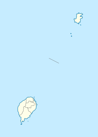
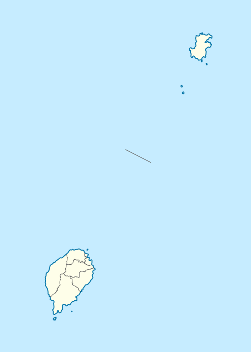
Deutsch: Positionskarte von São Tomé and Príncipe
Quadratische Plattkarte. Geographische Begrenzung der Karte:
English: Location map of São Tomé and Príncipe
Equirectangular projection. Geographic limits of the map:
|
| ڕێکەوت | |
| سەرچاوە |
بەرھەمی خۆم, using
|
| بەرھەمھێنەر | NordNordWest |
| ڕێپێدان (بەکارھێنانەوەی ئەم پەڕگەیە) |
من، ھەڵگری مافی لەبەرگرتنەوەی ئەم بەرھەمە، لەژێر ئەم مۆڵەتنامەیەدا بڵاوی دەکەمەوە: ئەم پەڕگەیە لە ژێر مۆڵەتنامەی
Creative Commons Attribution-Share Alike 3.0 Unported دایە.
|

|
This map has been made or improved in the German Kartenwerkstatt (Map Lab). You can propose maps to improve as well.
|
مێژووی پەڕگە
کرتە بکە لەسەر یەکێک لە ڕێکەوت/کاتەکان بۆ بینینی پەڕگەکە بەو شێوەی لەو کاتەدا بووە.
| ڕێکەوت/کات | ھێما | ئەندازە | بەکارھێنەر | تێبینی | |
|---|---|---|---|---|---|
| هەنووکە | ١٩:٠١، ٢٧ی تشرینی دووەمی ٢٠٢٠ | | ٤٩٦ لە ٦٩٤ (١٠ کیلۆبایت) | NordNordWest | more exact |
| ١٥:٢٥، ١٧ی حوزەیرانی ٢٠١٤ |  | ٤٩٦ لە ٦٩٤ (٩ کیلۆبایت) | NordNordWest | corr | |
| ١٩:٤٠، ٥ی تشرینی یەکەمی ٢٠٠٩ |  | ٤٩٦ لە ٦٩٤ (١٣ کیلۆبایت) | NordNordWest | {{int:filedesc}} {{Information |Description= {{de|Positionskarte von São Tomé and Príncipe}} Quadratische Plattkarte. Geographische Begrenzung der Karte: * N: 1.9° N * S: 0.2° S * W: 6.2° E * O: 7.7° E {{en|Location |
بەکارھێنانی پەڕگە
ئەم پەڕەیە ئەم پەڕگەیە بەکار دەھێنێت:
بەکارھێنانی سەرانسەریی پەڕگە
ئەم ویکیانەی دیکەی خوارەوەش ئەم پەڕگە بەکاردێنن:
- بەکارھێنان لە af.wikipedia.org
- بەکارھێنان لە am.wikipedia.org
- بەکارھێنان لە an.wikipedia.org
- بەکارھێنان لە ar.wikipedia.org
- بەکارھێنان لە ast.wikipedia.org
- بەکارھێنان لە ba.wikipedia.org
- بەکارھێنان لە be-tarask.wikipedia.org
- بەکارھێنان لە be.wikipedia.org
- بەکارھێنان لە bg.wikipedia.org
- بەکارھێنان لە bn.wikipedia.org
- بەکارھێنان لە bs.wikipedia.org
- بەکارھێنان لە ca.wikipedia.org
- بەکارھێنان لە ceb.wikipedia.org
بینینی بەکارھێنانی گشتی زیاتری ئەم پەڕگەیە.