
پەڕگە:PIA14294 Sumner1 curiosity landing site.jpg

قەبارەی ئەم پێشبینینە: ٨٠٠ لە ٤٥٠ پیکسەڵ. ڕێزەلووشنەکانی تر: ٣٢٠ لە ١٨٠ پیکسەڵ | ٦٤٠ لە ٣٦٠ پیکسەڵ | ١٬٠٢٤ لە ٥٧٦ پیکسەڵ | ١٬٢٨٠ لە ٧٢٠ پیکسەڵ | ١٬٩٢٠ لە ١٬٠٨٠ پیکسەڵ.
پەڕگەی سەرەکی (١٬٩٢٠ × ١٬٠٨٠ پیکسڵ، قەبارەی پەڕگە: ٩٦٤ کیلۆبایت، جۆری ئێم ئای ئێم ئی: image/jpeg)
کورتە
| وەسف |
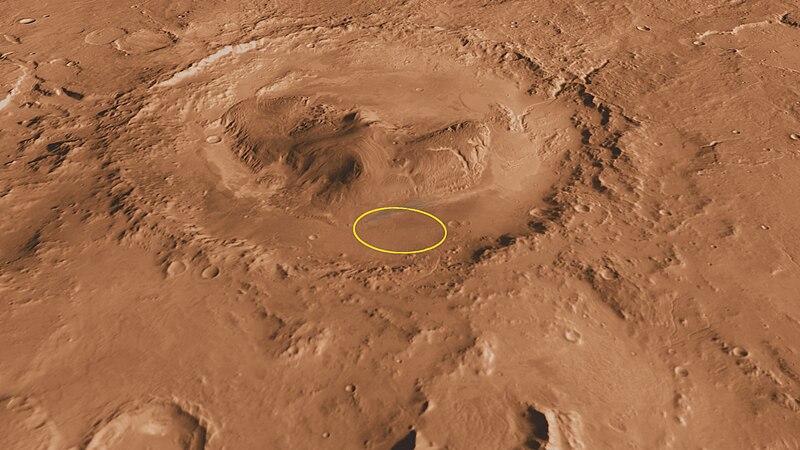
English: This oblique, southward-looking view of Gale crater shows the landing site and the mound of layered rocks that NASA's Mars Science Laboratory will investigate. The landing site is in the smooth area in front of the mound (marked by a yellow ellipse, which is 12.4 miles[20 kilometers] by 15.5 miles [25 kilometers]).
Gale crater is 96 miles (154 kilometers) in diameter and holds a layered mountain rising about 3 miles (5 kilometers) above the crater floor. |
| ڕێکەوت | |
| سەرچاوە | http://mars.jpl.nasa.gov/msl/multimedia/images/?imageid=3551 |
| بەرھەمھێنەر | NASA/JPL-Caltech/ASU/UA |
مۆڵەتنامە
| This file is in the public domain in the United States because it was solely created by NASA. NASA copyright policy states that "NASA material is not protected by copyright unless noted". (See Template:PD-USGov, NASA copyright policy page or JPL Image Use Policy.) | ||
 |
Warnings:
|
مێژووی پەڕگە
کرتە بکە لەسەر یەکێک لە ڕێکەوت/کاتەکان بۆ بینینی پەڕگەکە بەو شێوەی لەو کاتەدا بووە.
| ڕێکەوت/کات | ھێما | ئەندازە | بەکارھێنەر | تێبینی | |
|---|---|---|---|---|---|
| هەنووکە | ١٦:١٦، ٢٢ی تەممووزی ٢٠١١ | | ١٬٩٢٠ لە ١٬٠٨٠ (٩٦٤ کیلۆبایت) | Nova13 | {{Information |Description ={{en|1=This oblique, southward-looking view of Gale crater shows the landing site and the mound of layered rocks that NASA's Mars Science Laboratory will investigate. The landing site is in the smooth area in front of the mo |
بەکارھێنانی پەڕگە
ئەم پەڕەی 2ە ئەم پەڕگەیە بەکار دەھێنێت:
بەکارھێنانی سەرانسەریی پەڕگە
ئەم ویکیانەی دیکەی خوارەوەش ئەم پەڕگە بەکاردێنن:
- بەکارھێنان لە ar.wikipedia.org
- بەکارھێنان لە be.wikipedia.org
- بەکارھێنان لە ca.wikipedia.org
- بەکارھێنان لە fi.wikipedia.org
- بەکارھێنان لە fr.wikipedia.org
- بەکارھێنان لە hy.wikipedia.org
- بەکارھێنان لە pl.wikipedia.org
- بەکارھێنان لە ru.wikipedia.org
- بەکارھێنان لە ru.wikinews.org
- بەکارھێنان لە sk.wikipedia.org
- بەکارھێنان لە uk.wikipedia.org