
پەڕگە:Mohammad adil-Rashidun-empire-at-its-peak-close.PNG
قەبارەی ئەم پێشبینینە: ٨٠٠ لە ٣٨٨ پیکسەڵ. ڕێزەلووشنەکانی تر: ٣٢٠ لە ١٥٥ پیکسەڵ | ٦٤٠ لە ٣١٠ پیکسەڵ | ١٬١٩٦ لە ٥٨٠ پیکسەڵ.
پەڕگەی سەرەکی (١٬١٩٦ × ٥٨٠ پیکسڵ، قەبارەی پەڕگە: ٥٨ کیلۆبایت، جۆری ئێم ئای ئێم ئی: image/png)

|
This map image could be re-created using vector graphics as an SVG file. This has several advantages; see Commons:Media for cleanup for more information. If an SVG form of this image is available, please upload it and afterwards replace this template with
{{vector version available|new image name}}.
It is recommended to name the SVG file “Mohammad adil-Rashidun-empire-at-its-peak-close.svg”—then the template Vector version available (or Vva) does not need the new image name parameter. |
کورتە
| وەسف |
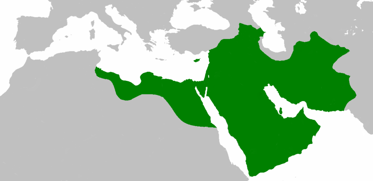
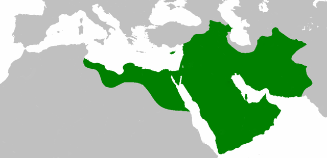
العربية: اتساع الدولة الإسلامية في عهد الخليفة عثمان بن عفان English: Empire of the Rashidun Caliphate at its peak. |
|||
| ڕێکەوت | ٢١ی تەممووزی ٢٠٠٧ (original upload date) | |||
| سەرچاوە | Transferred from en.wikipedia to Commons. | |||
| بەرھەمھێنەر | Mohammad adil at ئینگلیزی ویکیپیدیا | |||
| وەشانەکانی تر |
|

مۆڵەتنامە
Mohammad adil from en.wikipedia.org، ھەڵگری مافی لەبەرگرتنەوەی ئەم بەرھەمە، لەژێر ئەم مۆڵەتنامەیەدا بڵاوی دەکاتەوە:
| ئەم پەڕگەیە لە ژێر مۆڵەتنامەی
Creative Commons Attribution-Share Alike 3.0 Unported دایە. Subject to disclaimers. |
||
| دانەپاڵ: Mohammad adil from en.wikipedia.org | ||
| ||
| This licensing tag was added to this file as part of the GFDL licensing update. |

|
ڕێگەدراوە بە لەبەرگرتنەوە، دابەشکردن ھەروەھا/یان سازاندنی ئەم بەڵگەنامەیە لەژێر مەرجی مۆڵەتی GNU بۆ بەڵگەنامەی ئازاد، وەشانی ١.٢ یان ھەر وەشانێکی تری دواتر کە بڵاوکراوەتەوە لەلایەن دامەزراوەی بەرنامەی ئازاد، بەبێ ھیچ بەشێکی جیاواز، بەبێ نووسین لەسەر بەرگی پێشەوە و دواوەی. وێنەیەک لەمۆڵەتەکە لە بەشێکدا ھەیە کە ناوی مۆڵەتی GNU بۆ بەڵگەنامەی ئازادە. Subject to disclaimers. |
Original upload log
The original description page was here. All following user names refer to en.wikipedia.
- 2010-04-25 09:06 Cplakidas 1196×580× (50435 bytes) whoops
- 2010-04-25 08:59 Cplakidas 1196×580× (50513 bytes) corrections: Crete, Rhodes, Sicily, Cilicia, W. Armenia & Iberia were raided and invaded, but not permanently occupied until much later. In Africa, the Exarchate of Carthage still controlled most of Tunisia, and no Arabs had yet reached Spain.
- 2009-05-01 06:26 Mohammad adil 1196×580× (46594 bytes) {{GFDL-self-with-disclaimers}}
- 2009-01-26 14:13 Mohammad adil 1196×580× (95308 bytes)
- 2008-03-28 21:12 Mohammad adil 1400×680× (48613 bytes) {{GFDL-self-with-disclaimers}}
- 2008-03-28 21:08 Mohammad adil 1400×680× (48472 bytes) {{GFDL-self-with-disclaimers}}
- 2007-07-21 19:15 Mohammad adil 1400×690× (47455 bytes) {{GFDL-self-with-disclaimers}}
مێژووی پەڕگە
کرتە بکە لەسەر یەکێک لە ڕێکەوت/کاتەکان بۆ بینینی پەڕگەکە بەو شێوەی لەو کاتەدا بووە.
| ڕێکەوت/کات | ھێما | ئەندازە | بەکارھێنەر | تێبینی | |
|---|---|---|---|---|---|
| هەنووکە | ١٩:٥٩، ١٠ی کانوونی یەکەمی ٢٠١٨ | | ١٬١٩٦ لە ٥٨٠ (٥٨ کیلۆبایت) | عبد الله | Reverted to version as of 19:41, 10 December 2018 (UTC) |
| ١٩:٥٧، ١٠ی کانوونی یەکەمی ٢٠١٨ |  | ١٬١٩٦ لە ٥٨٠ (٥٨ کیلۆبایت) | عبد الله | إزالة خطوط مزعجة | |
| ١٩:٤١، ١٠ی کانوونی یەکەمی ٢٠١٨ |  | ١٬١٩٦ لە ٥٨٠ (٥٨ کیلۆبایت) | عبد الله | إزالة خطوط مضايقة | |
| ٠٤:٢٩، ١٢ی کانوونی یەکەمی ٢٠١٧ |  | ١٬١٩٦ لە ٥٨٠ (٣٧ کیلۆبایت) | Swazzo | Reverted to version as of 23:30, 2 May 2014 (UTC) unnecessary | |
| ١١:٢٥، ٩ی کانوونی یەکەمی ٢٠١٧ |  | ١٬١٩٦ لە ٥٨٠ (٤٤ کیلۆبایت) | Mehrdad 12 | [[]][[Media:]]]] | |
| ٢٣:٣٠، ٢ی ئایاری ٢٠١٤ |  | ١٬١٩٦ لە ٥٨٠ (٣٧ کیلۆبایت) | HistoryofIran | Corrected map; regions such as Ghur was not under Rashidun control. | |
| ٠٩:٢٧، ١٩ی تشرینی یەکەمی ٢٠١٢ |  | ١٬١٩٦ لە ٥٨٠ (٤٥ کیلۆبایت) | Cplakidas | correction: the Muslims had not yet established themselves beyond the Caucasus, Derbent and its environs were conquered in the 8th century | |
| ٠٨:٥١، ٢٥ی تەممووزی ٢٠١٢ |  | ١٬١٩٦ لە ٥٨٠ (٤٦ کیلۆبایت) | محک | see also:File:Age of Caliphs.png and:[http://en.wikipedia.org/wiki/Mazandaran#Post_Islamic_history] and:tapuria history book (Ibn Esfandiyar) | |
| ٠٩:٠٧، ١٧ی حوزەیرانی ٢٠١٢ |  | ١٬١٩٦ لە ٥٨٠ (٤٩ کیلۆبایت) | OgreBot | (BOT): Reverting to most recent version before archival | |
| ٠٩:٠٦، ١٧ی حوزەیرانی ٢٠١٢ |  | ١٬١٩٦ لە ٥٨٠ (٤٩ کیلۆبایت) | OgreBot | (BOT): Uploading old version of file from en.wikipedia; originally uploaded on 2010-04-25 09:06:38 by Cplakidas |
بەکارھێنانی پەڕگە
ئەم پەڕەی 2ە ئەم پەڕگەیە بەکار دەھێنێت:
بەکارھێنانی سەرانسەریی پەڕگە
ئەم ویکیانەی دیکەی خوارەوەش ئەم پەڕگە بەکاردێنن:
- بەکارھێنان لە ace.wikipedia.org
- بەکارھێنان لە af.wikipedia.org
- بەکارھێنان لە ar.wikipedia.org
- عثمان بن عفان
- الخلفاء الراشدون
- زيد بن ثابت
- معركة أجنادين
- الحسن بن علي
- الحسين بن علي
- بلال بن رباح
- سقيفة بني ساعدة
- حروب الردة
- الفسطاط
- خالد بن الوليد
- أبو هريرة
- أبو الأسود الدؤلي
- مارية القبطية
- عمرو بن العاص
- سلمان الفارسي
- أسيد بن حضير
- سعد بن أبي وقاص
- عائشة بنت أبي بكر
- أم حبيبة
- سودة بنت زمعة
- أم سلمة
- الزبير بن العوام
- سعيد بن زيد
- سعد بن عبادة
- عبد الله بن عمر بن الخطاب
- أبان بن سعيد بن العاص
- أبو أيوب الأنصاري
- فتنة مقتل عثمان
- القوقاز
- عبد الله بن الزبير
- أبان بن عثمان بن عفان
- أنس بن مالك
- يزيد بن أبي سفيان
- معركة اليرموك
- معركة ذات الصواري
- طلحة بن عبيد الله
- المغيرة بن شعبة
- عبد الله بن سبأ
- زينب بنت جحش
- زينب بنت خزيمة
- جويرية بنت الحارث
- صفية بنت حيي بن أخطب
- ميمونة بنت الحارث
- أبو سفيان بن حرب
- أبو ذر الغفاري
- عبد الله بن عباس
بینینی بەکارھێنانی گشتی زیاتری ئەم پەڕگەیە.