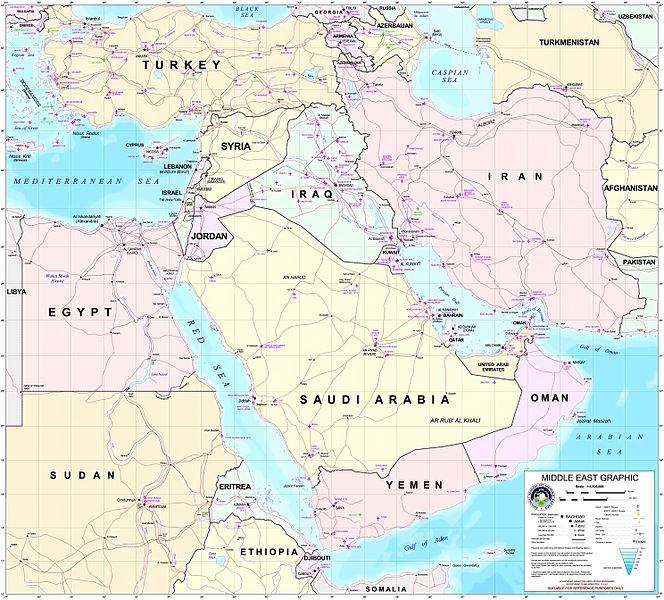
پەڕگە:Middle east graphic 2003.jpg

قەبارەی ئەم پێشبینینە: ٦٦٤ لە ٦٠٠ پیکسەڵ. ڕێزەلووشنەکانی تر: ٢٦٦ لە ٢٤٠ پیکسەڵ | ٥٣٢ لە ٤٨٠ پیکسەڵ | ٨٥٠ لە ٧٦٨ پیکسەڵ | ١٬١٣٤ لە ١٬٠٢٤ پیکسەڵ | ٢٬٢٦٨ لە ٢٬٠٤٨ پیکسەڵ | ٢٬٩٧٣ لە ٢٬٦٨٥ پیکسەڵ.
پەڕگەی سەرەکی (٢٬٩٧٣ × ٢٬٦٨٥ پیکسڵ، قەبارەی پەڕگە: ٣٫٩١ مێگابایت، جۆری ئێم ئای ئێم ئی: image/jpeg)
مێژووی پەڕگە
کرتە بکە لەسەر یەکێک لە ڕێکەوت/کاتەکان بۆ بینینی پەڕگەکە بەو شێوەی لەو کاتەدا بووە.
| ڕێکەوت/کات | ھێما | ئەندازە | بەکارھێنەر | تێبینی | |
|---|---|---|---|---|---|
| هەنووکە | ٢٢:٣٠، ٨ی شوباتی ٢٠١٢ |  | ٢٬٩٧٣ لە ٢٬٦٨٥ (٣٫٩١ مێگابایت) | M0tty | Remove compression artefacts by a bilateral filtering. |
| ٢١:٤٣، ١٤ی تەممووزی ٢٠٠٦ |  | ٢٬٩٧٣ لە ٢٬٦٨٥ (١٬٠١٣ کیلۆبایت) | Unquietwiki | ''Courtesy of the University of Texas Libraries, The University of Texas at Austin'' [http://www.lib.utexas.edu/maps/middle_east.html http://www.lib.utexas.edu/maps/middle_east.html] High-resolution political / railway / roadmap of the Middle East. |
بەکارھێنانی پەڕگە
ئەم پەڕەی 2ە ئەم پەڕگەیە بەکار دەھێنێت:
بەکارھێنانی سەرانسەریی پەڕگە
ئەم ویکیانەی دیکەی خوارەوەش ئەم پەڕگە بەکاردێنن:
- بەکارھێنان لە ar.wikipedia.org
- ويكيبيديا:قوالب/بذور
- ويكيبيديا:قوالب/بذور/جدول بذرة 1
- قالب:بذرة جغرافيا الشرق الأوسط
- بادية الشام
- محافظة العاصمة (البحرين)
- خليج عدن
- دزفول
- زاغروس
- مسجد سليمان
- زاينده
- مسرح أحداث الشرق الأوسط خلال الحرب العالمية الثانية
- الحويزة (مدينة)
- قائمة جزر الخليج العربي
- شرق المتوسط
- قائمة نزاعات الشرق الأوسط الحديثة
- مستخدم:Adnanzoom/مساعدات
- عبد الله بن سعيد
- قرار مجلس الأمن التابع للأمم المتحدة رقم 1381
- مستخدم:ASammour/بذرة-بوابة
- شرف الدين بن الحسن
- فخر الدين بن عدي
- صخر بن صخر بن مسافر
- قالب:بذرة أعلام الشرق الأوسط
- أبجر التاسع
- بەکارھێنان لە arz.wikipedia.org
- بەکارھێنان لە ba.wikipedia.org
- بەکارھێنان لە bn.wikipedia.org
- بەکارھێنان لە ca.wikipedia.org
- بەکارھێنان لە ce.wikipedia.org
- بەکارھێنان لە el.wikipedia.org
- بەکارھێنان لە en.wikipedia.org
- Talk:Arabic
- Talk:Cyprus
- Talk:Persian language
- Talk:Israel
- Talk:Knights Templar
- Talk:Nostratic languages
- Talk:Palestine (region)
- Talk:Palestinian National Authority
- Talk:Romani people
- Talk:West Bank
- Talk:Gulf War
- Talk:Jews
- Talk:Zoroastrianism
- Talk:Gaza Strip
- Talk:Syria
- Talk:Georgia (country)
- Talk:History of Cyprus
بینینی بەکارھێنانی گشتی زیاتری ئەم پەڕگەیە.


