
پەڕگە:Map of Argentina Demis.png
قەبارەی ئەم پێشبینینە: ٣١٧ لە ٦٠٠ پیکسەڵ. ڕێزەلووشنەکانی تر: ١٢٧ لە ٢٤٠ پیکسەڵ | ٢٥٤ لە ٤٨٠ پیکسەڵ | ٧٢٧ لە ١٬٣٧٥ پیکسەڵ.
پەڕگەی سەرەکی (٧٢٧ × ١٬٣٧٥ پیکسڵ، قەبارەی پەڕگە: ٣٨٤ کیلۆبایت، جۆری ئێم ئای ئێم ئی: image/png)
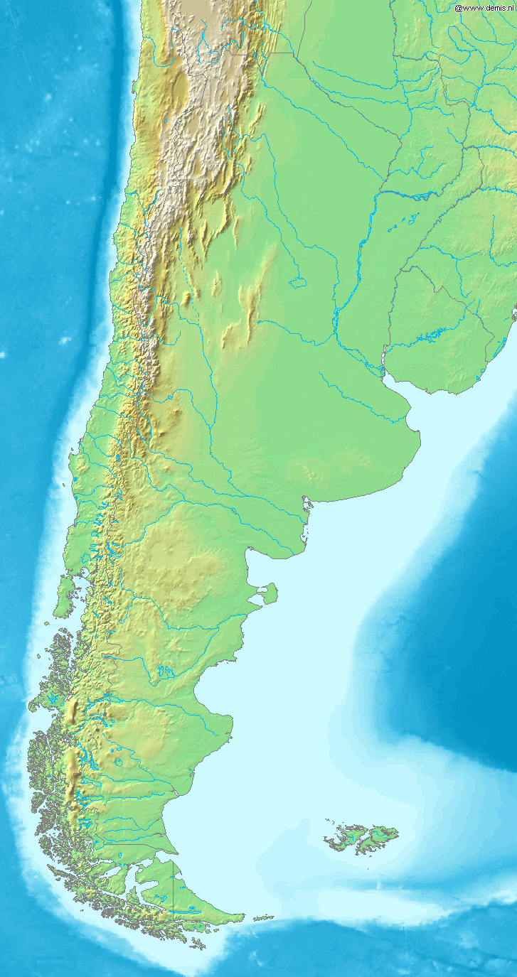
Map of Argentina
Bounding box West -77°, South -57°, East -52°, North -20°. Center at 38°30′00″S 64°30′00″W / 38.50000°S 64.50000°W.
This image is in the public domain because it came from the site https://www.demis.nl/products/web-map-server/examples/ and was released by the copyright holder. Permission is granted to copy, distribute and/or modify this map since it is based on free of copyright images from: www.demis.nl. See also approval email on de.wp and its clarification.
|
| This work has been released into the public domain by its copyright holder, www.demis.nl. This applies worldwide. لە ھەندێ وڵاتدا لەوانەیە یاسا، ڕێگە بەمە نەدات؛ لەو کاتەدا: www.demis.nl مافی بەکارھێنانی ئەم بەرھەمە بۆ ھەر مەبەستێک دەبەخشێ بە ھەموو کەسێک، بێ ھیچ مەرجێک، مەگەر ئەو چەشنە مەرجانە کە یاسا ھەبوونیانی بە پێویستی بزانێت.
|
مێژووی پەڕگە
کرتە بکە لەسەر یەکێک لە ڕێکەوت/کاتەکان بۆ بینینی پەڕگەکە بەو شێوەی لەو کاتەدا بووە.
| ڕێکەوت/کات | ھێما | ئەندازە | بەکارھێنەر | تێبینی | |
|---|---|---|---|---|---|
| هەنووکە | ١٩:٤٦، ٢٠ی کانوونی یەکەمی ٢٠٠٦ | | ٧٢٧ لە ١٬٣٧٥ (٣٨٤ کیلۆبایت) | Mats Halldin~commonswiki | Map of Argentina Bounding box West -77°, South -57°, East -52°, North -20°. Center at {{coor d|38.50000|S|64.50000|W|scale:22200000}}. {{demis-pd}} category:maps of Argentina |
بەکارھێنانی پەڕگە
ئەم پەڕەی 4ە ئەم پەڕگەیە بەکار دەھێنێت:
بەکارھێنانی سەرانسەریی پەڕگە
ئەم ویکیانەی دیکەی خوارەوەش ئەم پەڕگە بەکاردێنن:
- بەکارھێنان لە bs.wikipedia.org
- بەکارھێنان لە ca.wikipedia.org
- بەکارھێنان لە cs.wikipedia.org
- بەکارھێنان لە en.wikipedia.org
- بەکارھێنان لە eo.wikipedia.org
- بەکارھێنان لە es.wikipedia.org
- بەکارھێنان لە es.wikinews.org
- بەکارھێنان لە fa.wikipedia.org
- بەکارھێنان لە fi.wikipedia.org
- بەکارھێنان لە fr.wikipedia.org
- بەکارھێنان لە gl.wikipedia.org
- بەکارھێنان لە id.wikipedia.org
- بەکارھێنان لە ilo.wikipedia.org
- بەکارھێنان لە is.wikipedia.org
- بەکارھێنان لە it.wikipedia.org
- بەکارھێنان لە ja.wikipedia.org
- بەکارھێنان لە ka.wikipedia.org
- بەکارھێنان لە la.wikipedia.org
- بەکارھێنان لە mk.wikipedia.org
- بەکارھێنان لە mr.wikipedia.org
- بەکارھێنان لە nl.wikipedia.org
- بەکارھێنان لە oc.wikipedia.org
- بەکارھێنان لە pa.wikipedia.org
- بەکارھێنان لە pnb.wikipedia.org
- بەکارھێنان لە pt.wikipedia.org
- بەکارھێنان لە ru.wikipedia.org
- بەکارھێنان لە sh.wikipedia.org
- بەکارھێنان لە sv.wikipedia.org
- بەکارھێنان لە uk.wikipedia.org
- بەکارھێنان لە ur.wikipedia.org
- بەکارھێنان لە vi.wikipedia.org
- بەکارھێنان لە xmf.wikipedia.org
- بەکارھێنان لە zh-min-nan.wikipedia.org
- بەکارھێنان لە zh.wikipedia.org