
پەڕگە:Kingdom of Hungary counties-2.svg

Size of this PNG preview of this SVG file: ٧٧٩ لە ٥١٣ پیکسەڵ. ڕێزەلووشنەکانی تر: ٣٢٠ لە ٢١١ پیکسەڵ | ٦٤٠ لە ٤٢١ پیکسەڵ | ١٬٠٢٤ لە ٦٧٤ پیکسەڵ | ١٬٢٨٠ لە ٨٤٣ پیکسەڵ | ٢٬٥٦٠ لە ١٬٦٨٦ پیکسەڵ.
پەڕگەی سەرەکی (پەڕگەی SVG، بە ناو ٧٧٩ × ٥١٣ پیکسەڵ، قەبارەی پەڕگە: ٢٦٥ کیلۆبایت)
| وەسف |
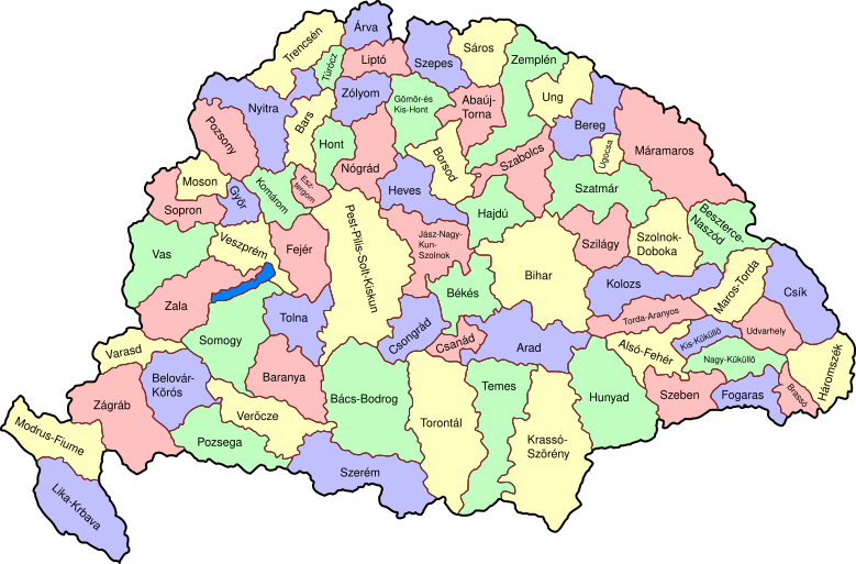
Map of counties of Kingdom of Hungary (Hungary proper and Croatia & Slavonia), 1886-1918. I have organised this into layers: Three layers of paths for the counties, for the county borders, and for external border. and one layer for the text labels. I have added basic styles and classified all elements. I have given all elements reasonable IDs the counties (the county name) and the borders (the names of the counties on each side) and the text labels (the names of the counties, with underscores indicating where they are split across labels). The counties are classed into four styles to make a four colour map, of course the colours can be changed just by changing the style (there as a fifth style for Lake Balaton, which does not show up very well on tis uploaded one). The main thing now is to fix the text styles. |
||
| ڕێکەوت | (UTC) | ||
| سەرچاوە | |||
| بەرھەمھێنەر |
|
||
| وەشانەکانی تر |
|

| This is a retouched picture, which means that it has been digitally altered from its original version. Modifications: As described - added more useful metadata and structure. The original can be viewed here: Kingdom of Hungary counties.svg:
|
من، ھەڵگری مافی لەبەرگرتنەوەی ئەم بەرھەمە، لەژێر ئەم مۆڵەتنامەیەدا بڵاوی دەکەمەوە:
| من، هەڵگری مافی لەبەرگرتنەوەی ئەم بەرھەمە، ئەم بەرھەمە بڵاودەکەمەوە بۆ پاوانی گشتی (public domain). ئەم مافە بۆ سەرانسەری جیھانە. لە ھەندێ وڵاتدا لەوانەیە یاسا، ڕێگە بەمە نەدات؛ لەو کاتەدا: من مافی بەکارھێنانی ئەم بەرھەمە بۆ ھەر مەبەستێک دەبەخشم بە ھەموو کەسێک، بێ ھیچ مەرجێک، مەگەر ئەو چەشنە مەرجانە کە یاسا ھەبوونیانی بە پێویستی بزانێت. |
Original upload log
This image is a derivative work of the following images:
- File:Kingdom_of_Hungary_counties.svg licensed with PD-self
- 2007-08-20T20:25:30Z Xavax 779x513 (240591 Bytes) == Summary == {{Information| |Description= Map of counties of Hungary with Croatia & Slavonia, 1886-1918 |Source=own drawing |Date=April 30, 2006 |Author=[[User:IMeowbot]] |Permission= |other_versions= }} == Licensing == {{P
- 2006-04-30T22:10:47Z IMeowbot 779x513 (228524 Bytes) line weight
- 2006-04-30T21:34:49Z IMeowbot 779x513 (225942 Bytes)
- 2006-04-30T18:34:30Z IMeowbot 779x513 (199213 Bytes) {{Information| |Description= Map of late 1870s Hungary counties |Source=own drawing |Date=April 30, 2006 |Author=[[User:IMeowbot]] |Permission= |other_versions= }}
Uploaded with derivativeFX
مێژووی پەڕگە
کرتە بکە لەسەر یەکێک لە ڕێکەوت/کاتەکان بۆ بینینی پەڕگەکە بەو شێوەی لەو کاتەدا بووە.
| ڕێکەوت/کات | ھێما | ئەندازە | بەکارھێنەر | تێبینی | |
|---|---|---|---|---|---|
| هەنووکە | ١٧:٥٧، ٥ی کانوونی یەکەمی ٢٠٠٩ | | ٧٧٩ لە ٥١٣ (٢٦٥ کیلۆبایت) | SimonTrew | I missed some fixes of Veszprém |
| ١٧:٥٥، ٥ی کانوونی یەکەمی ٢٠٠٩ |  | ٧٧٩ لە ٥١٣ (٢٦٥ کیلۆبایت) | SimonTrew | Fix spelling of Vesprém, as I have just done on original. | |
| ١٤:٢٩، ٣ی کانوونی یەکەمی ٢٠٠٩ |  | ٧٧٩ لە ٥١٣ (٢٦٥ کیلۆبایت) | SimonTrew | Fix spelling of Pozsony, as I have just done on original work | |
| ١٣:٣٧، ٣ی کانوونی یەکەمی ٢٠٠٩ |  | ٧٧٩ لە ٥١٣ (٢٦٥ کیلۆبایت) | SimonTrew | Made four colour map. The text still only uses one style at the moment, this needs to be made to match the four styles used for the four colours for the counties, but this is easier to do once it is uploaded and I can print the png. Sorry if this is "not | |
| ١١:٢٩، ٣ی کانوونی یەکەمی ٢٠٠٩ |  | ٧٧٩ لە ٥١٣ (٢٨٧ کیلۆبایت) | SimonTrew | Fixed the few errors in borders, removed unnecessary style fields from text (Inkscape adds them but they are covered by other fields), text still needs doing better | |
| ٠١:١٦، ٣ی کانوونی یەکەمی ٢٠٠٩ |  | ٧٧٩ لە ٥١٣ (٢٨٦ کیلۆبایت) | SimonTrew | {{Information |Description=Map of counties of Kingdom of Hungary (Hungary proper and Croatia & Slavonia), 1886-1918. I have organised this into layers: Three layers of paths for the counties, for the county borders, and for external border. and one layer |
بەکارھێنانی پەڕگە
ئەم پەڕەیە ئەم پەڕگەیە بەکار دەھێنێت:
بەکارھێنانی سەرانسەریی پەڕگە
ئەم ویکیانەی دیکەی خوارەوەش ئەم پەڕگە بەکاردێنن:
- بەکارھێنان لە ar.wikipedia.org
- بەکارھێنان لە bs.wikipedia.org
- بەکارھێنان لە ceb.wikipedia.org
- بەکارھێنان لە da.wikipedia.org
- بەکارھێنان لە de.wikipedia.org
- بەکارھێنان لە en.wikipedia.org
- User talk:Random user 8384993
- Wikipedia talk:WikiProject Hungary/Archive 2
- Module:Location map/data/Kingdom of Hungary/doc
- Wikipedia:Redirects for discussion/Log/2015 April 19
- User:Drkazmer/Jewish centres in the Kingdom of Hungary
- Wikipedia:Graphics Lab/Map workshop/Archive/2017/Sep 2017
- Module:Location map/data/Kingdom of Hungary
- بەکارھێنان لە fa.wikipedia.org
- بەکارھێنان لە fr.wikipedia.org
- بەکارھێنان لە hu.wikipedia.org
- بەکارھێنان لە kn.wikipedia.org
- بەکارھێنان لە pt.wikipedia.org
- بەکارھێنان لە rue.wikipedia.org
- بەکارھێنان لە si.wikipedia.org
- بەکارھێنان لە tg.wikipedia.org
- بەکارھێنان لە tr.wikipedia.org
- بەکارھێنان لە uz.wikipedia.org
- بەکارھێنان لە war.wikipedia.org