
پەڕگە:Karta över Japan vid 1900-talets början (ur Nordisk familjebok).jpg

قەبارەی ئەم پێشبینینە: ٤٣٩ لە ٦٠٠ پیکسەڵ. ڕێزەلووشنەکانی تر: ١٧٦ لە ٢٤٠ پیکسەڵ | ٣٥١ لە ٤٨٠ پیکسەڵ | ٥٦٢ لە ٧٦٨ پیکسەڵ | ٧٥٠ لە ١٬٠٢٤ پیکسەڵ | ٢٬٥٤٨ لە ٣٬٤٨٠ پیکسەڵ.
پەڕگەی سەرەکی (٢٬٥٤٨ × ٣٬٤٨٠ پیکسڵ، قەبارەی پەڕگە: ١٫٨٦ مێگابایت، جۆری ئێم ئای ئێم ئی: image/jpeg)
.jpg)
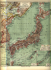
Svenska: Karta över Japan vid 1900-talets början
English: Map of Japan at the beginning of the 1900s
日本語: 1900年代初頭の日本地図
- Source: Nordisk familjebok [1]
This image was first published in the 1st (1876–1899), 2nd (1904–1926) or 3rd (1923–1937) edition of Nordisk familjebok. The copyrights for that book have expired and this image is in the public domain, because images had no named authors and the book was published more than 70 years ago.
|
This image (or other media file) is in the public domain because its copyright has expired and its author is anonymous.
This applies to the European Union and those countries with a copyright term of 70 years after the work was made available to the public and the author never disclosed their identity. Important: Always mention where the image comes from, as far as possible, and make sure the author never claimed authorship. |
 | |
 |
Note: In Germany and possibly other countries, certain anonymous works published before July 1, 1995 are copyrighted until 70 years after the death of the author. See Übergangsrecht. Please use this template only if the author never claimed authorship or their authorship never became public in any other way. If the work is anonymous or pseudonymous (e.g., published only under a corporate or organization's name), use this template for images published more than 70 years ago.
For a work made available to the public in the United Kingdom, please use Template:PD-UK-unknown instead.
|
مێژووی پەڕگە
کرتە بکە لەسەر یەکێک لە ڕێکەوت/کاتەکان بۆ بینینی پەڕگەکە بەو شێوەی لەو کاتەدا بووە.
| ڕێکەوت/کات | ھێما | ئەندازە | بەکارھێنەر | تێبینی | |
|---|---|---|---|---|---|
| هەنووکە | ٢١:٤٩، ٢٦ی نیسانی ٢٠٠٥ | | ٢٬٥٤٨ لە ٣٬٤٨٠ (١٫٨٦ مێگابایت) | Den fjättrade ankan~commonswiki | *{{Svenska}} Karta över Japan vid 1900-talets början *{{English}} Map of Japan at the beginning of the 1900s *Source: Nordisk familjebok {{PD-Ugglan}} Category:Japan Category:20th century maps |
بەکارھێنانی پەڕگە
ئەم پەڕەیە ئەم پەڕگەیە بەکار دەھێنێت:
بەکارھێنانی سەرانسەریی پەڕگە
ئەم ویکیانەی دیکەی خوارەوەش ئەم پەڕگە بەکاردێنن:
- بەکارھێنان لە da.wikipedia.org
- بەکارھێنان لە de.wikisource.org
- بەکارھێنان لە pl.wikipedia.org
- بەکارھێنان لە simple.wikipedia.org
- بەکارھێنان لە sq.wikipedia.org
- بەکارھێنان لە sv.wikipedia.org
.jpg)