
پەڕگە:Japan kyushu map small.png
رەزۆلوشنی سەرتر لەمە لە بەردەست دا نیە.
Japan_kyushu_map_small.png (٢٣٥ × ٣٠٠ پیکسڵ، قەبارەی پەڕگە: ٦ کیلۆبایت، جۆری ئێم ئای ئێم ئی: image/png)

|
This map image could be re-created using vector graphics as an SVG file. This has several advantages; see Commons:Media for cleanup for more information. If an SVG form of this image is available, please upload it and afterwards replace this template with
{{vector version available|new image name}}.
It is recommended to name the SVG file “Japan kyushu map small.svg”—then the template Vector version available (or Vva) does not need the new image name parameter. |
- What:
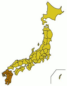
- English: A location map showing the location of Kyushu in relation to Japan.
- Latina: Charta geographica locum Ximi inter Iaponiam et eius provincias monstrans.
- Whence: From the English Wikipedia (Image:Japan kyushu map small.png), first uploaded by User:Synthetik.
Small map of Kyushu region
Map outline from public domain maps at http://aoki2.si.gunma-u.ac.jp/map/map.html

|
Shigenobu AOKI, the copyright holder of this work, allows anyone to use it for any purpose including unrestricted redistribution, commercial use, and modification.
|
مێژووی پەڕگە
کرتە بکە لەسەر یەکێک لە ڕێکەوت/کاتەکان بۆ بینینی پەڕگەکە بەو شێوەی لەو کاتەدا بووە.
| ڕێکەوت/کات | ھێما | ئەندازە | بەکارھێنەر | تێبینی | |
|---|---|---|---|---|---|
| هەنووکە | ٠٣:٤٥، ٥ی شوباتی ٢٠٠٥ | | ٢٣٥ لە ٣٠٠ (٦ کیلۆبایت) | Muke | From the English Wikipedia, {{PD}} |
بەکارھێنانی پەڕگە
ئەم پەڕەیە ئەم پەڕگەیە بەکار دەھێنێت:
بەکارھێنانی سەرانسەریی پەڕگە
ئەم ویکیانەی دیکەی خوارەوەش ئەم پەڕگە بەکاردێنن:
- بەکارھێنان لە af.wikipedia.org
- بەکارھێنان لە ar.wikipedia.org
- بەکارھێنان لە az.wikipedia.org
- بەکارھێنان لە ba.wikipedia.org
- بەکارھێنان لە be.wikipedia.org
- بەکارھێنان لە bg.wikipedia.org
- بەکارھێنان لە bn.wikipedia.org
- بەکارھێنان لە br.wikipedia.org
- بەکارھێنان لە cs.wikipedia.org
- بەکارھێنان لە cy.wikipedia.org
- بەکارھێنان لە da.wikipedia.org
- بەکارھێنان لە de.wikipedia.org
- بەکارھێنان لە el.wikipedia.org
- بەکارھێنان لە en.wikinews.org
- بەکارھێنان لە es.wikipedia.org
- بەکارھێنان لە et.wikipedia.org
- بەکارھێنان لە fa.wikipedia.org
- بەکارھێنان لە fi.wiktionary.org
- بەکارھێنان لە fo.wikipedia.org
- بەکارھێنان لە frr.wikipedia.org
- بەکارھێنان لە fr.wikinews.org
- بەکارھێنان لە fr.wikivoyage.org
- بەکارھێنان لە fr.wiktionary.org
- بەکارھێنان لە gd.wikipedia.org
- بەکارھێنان لە gl.wikipedia.org
- بەکارھێنان لە hak.wikipedia.org
- بەکارھێنان لە ha.wikipedia.org
- بەکارھێنان لە he.wikipedia.org
- بەکارھێنان لە hi.wikipedia.org
- بەکارھێنان لە hr.wikipedia.org
- بەکارھێنان لە hu.wikipedia.org
- بەکارھێنان لە ilo.wikipedia.org
- بەکارھێنان لە is.wikipedia.org
- بەکارھێنان لە it.wikipedia.org
- بەکارھێنان لە it.wikivoyage.org
- بەکارھێنان لە ka.wikipedia.org
- بەکارھێنان لە kk.wikipedia.org
- بەکارھێنان لە la.wiktionary.org
- بەکارھێنان لە mk.wikipedia.org
- بەکارھێنان لە mr.wikipedia.org
- بەکارھێنان لە nn.wikipedia.org
بینینی بەکارھێنانی گشتی زیاتری ئەم پەڕگەیە.