
پەڕگە:Golan heights border.jpg

قەبارەی ئەم پێشبینینە: ٨٠٠ لە ٦٠٠ پیکسەڵ. ڕێزەلووشنەکانی تر: ٣٢٠ لە ٢٤٠ پیکسەڵ | ٦٤٠ لە ٤٨٠ پیکسەڵ | ١٬٠٢٤ لە ٧٦٨ پیکسەڵ | ١٬٢٨٠ لە ٩٦٠ پیکسەڵ | ٢٬٣٠٤ لە ١٬٧٢٨ پیکسەڵ.
پەڕگەی سەرەکی (٢٬٣٠٤ × ١٬٧٢٨ پیکسڵ، قەبارەی پەڕگە: ٦٢٥ کیلۆبایت، جۆری ئێم ئای ئێم ئی: image/jpeg)
کورتە
| وەسف |
Čeština: hranice mezi izraelem a sýrií v golanských výšinách
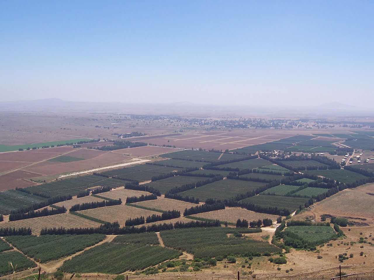
English: The Golan Heights' border with Syria proper. The Golan Heights end (and Syria begins) where the farmland ends. In the background is the deserted city of Quneitra in Syria. The white buildings on the right are mostly UN buildings.
Русский: Сирийско-израильская граница в Голанских высотах
Français : Vue sur la frontière syro-israélienne à la lisière des hauteurs du Golan. On distingue au loin la ville syrienne de Quneitra désertée. Les bâtiments de couleur claire à droite appartiennent pour la plupart à l'ONU. |
| ڕێکەوت | Taken in ٢٠٠٤ |
| سەرچاوە | Self-photographed (Original text: I took this picture.) |
| بەرھەمھێنەر | Masterpjz9 at en.wikipedia |
مۆڵەتنامە
This file is licensed under the Creative Commons Attribution-Share Alike 2.5 Generic license.
- تۆ ئازادی:
- بۆ بڵاکردنەوە – بۆ کۆپی کردن، دابەشکردن و دەستبەدەست ناردنی
- بۆ تێکەڵکردنەوە – بۆ سازاندنی کارەکە
- بەم مەرجانەی خوارەوە:
- دانەپاڵ – پێویستە باوەڕی گونجاو بدەیت، بەستەرێک بۆ مۆڵەتەکە دابین بکەیت و ئاماژە بەوە بکەیت کە ئایا گۆڕانکاری کراوە یان نا. دەتوانیت بە هەر شێوەیەکی گونجاو ئەوە بکەیت، بەڵام بە شێوەیەک نا کە وا دەربکەوێت کە مۆڵەتدەر پشتگیری تۆ یان بەکارهێنانەکەت بکات.
- بڵاوکردنەوەی گونجاو – ئەگەر لەسەر بنەمای ئەم کارە تێکەڵ، گۆڕان، یان ساز بکەی، پێویستە بەشدارییەکانت بە هەمان مۆڵەت یان هاوشێوەی مۆڵەتی ئەسڵی دابەش بکەی.
Original upload log
The original description page was here. All following user names refer to en.wikipedia.
- 2006-04-08 03:29 Masterpjz9 2304×1728× (639949 bytes) This is a photo of the Israeli Golan Heights border with Syria. The Golan Heights end (and Syria begins) where the farmland ends. In the background there is an deserted city of Syria, and the white buildings in the right are mostly UN buildings. I took t
مێژووی پەڕگە
کرتە بکە لەسەر یەکێک لە ڕێکەوت/کاتەکان بۆ بینینی پەڕگەکە بەو شێوەی لەو کاتەدا بووە.
| ڕێکەوت/کات | ھێما | ئەندازە | بەکارھێنەر | تێبینی | |
|---|---|---|---|---|---|
| هەنووکە | ٠٢:٤٥، ١٠ی نیسانی ٢٠١٢ | | ٢٬٣٠٤ لە ١٬٧٢٨ (٦٢٥ کیلۆبایت) | OgreBot | (BOT): Uploading old version of file from en.wikipedia; originally uploaded on 2006-04-08 03:29:30 by Masterpjz9 |
| ٢١:٠٩، ٣١ی تەممووزی ٢٠٠٦ |  | ٨٠٠ لە ٦٠٠ (٦٩ کیلۆبایت) | Becherka | Israeli golan heights border with syria hranice mezi izraelem a sýrií v golanských výšinách |
بەکارھێنانی پەڕگە
ئەم پەڕەی 2ە ئەم پەڕگەیە بەکار دەھێنێت:
بەکارھێنانی سەرانسەریی پەڕگە
ئەم ویکیانەی دیکەی خوارەوەش ئەم پەڕگە بەکاردێنن:
- بەکارھێنان لە ar.wikipedia.org
- بەکارھێنان لە be-tarask.wikipedia.org
- بەکارھێنان لە ca.wikipedia.org
- بەکارھێنان لە en.wikipedia.org
- بەکارھێنان لە fa.wikipedia.org
- بەکارھێنان لە fr.wikipedia.org
- بەکارھێنان لە he.wikipedia.org
- بەکارھێنان لە hu.wikipedia.org
- بەکارھێنان لە id.wikipedia.org
- بەکارھێنان لە ja.wikipedia.org
- بەکارھێنان لە ko.wikipedia.org
- بەکارھێنان لە ms.wikipedia.org
- بەکارھێنان لە mzn.wikipedia.org
- بەکارھێنان لە nl.wikipedia.org
- بەکارھێنان لە pt.wikipedia.org
- بەکارھێنان لە ru.wikipedia.org
- بەکارھێنان لە tg.wikipedia.org
- بەکارھێنان لە tr.wikipedia.org
- بەکارھێنان لە vi.wikipedia.org
- بەکارھێنان لە www.wikidata.org
- بەکارھێنان لە zh.wikipedia.org