
پەڕگە:GolanHistoricalBorders.svg

Size of this PNG preview of this SVG file: ٣٧٤ لە ٥٩٩ پیکسەڵ. ڕێزەلووشنەکانی تر: ١٥٠ لە ٢٤٠ پیکسەڵ | ٣٠٠ لە ٤٨٠ پیکسەڵ | ٤٧٩ لە ٧٦٨ پیکسەڵ | ٦٣٩ لە ١٬٠٢٤ پیکسەڵ | ١٬٢٧٩ لە ٢٬٠٤٨ پیکسەڵ | ٥٣٤ لە ٨٥٥ پیکسەڵ.
پەڕگەی سەرەکی (پەڕگەی SVG، بە ناو ٥٣٤ × ٨٥٥ پیکسەڵ، قەبارەی پەڕگە: ٥٤ کیلۆبایت)
کورتە
| وەسف |
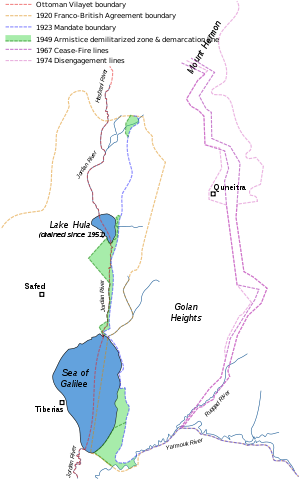
Historical Golan Heights boundaries:
1974 Disengagement lines. |
| ڕێکەوت | |
| سەرچاوە |
Self-made, based on:
|
| بەرھەمھێنەر | Doron |
مۆڵەتنامە
من، ھەڵگری مافی لەبەرگرتنەوەی ئەم بەرھەمە، لەژێر ئەم مۆڵەتنامەیەدا بڵاوی دەکەمەوە:

|
ڕێگەدراوە بە لەبەرگرتنەوە، دابەشکردن ھەروەھا/یان سازاندنی ئەم بەڵگەنامەیە لەژێر مەرجی مۆڵەتی GNU بۆ بەڵگەنامەی ئازاد، وەشانی ١.٢ یان ھەر وەشانێکی تری دواتر کە بڵاوکراوەتەوە لەلایەن دامەزراوەی بەرنامەی ئازاد، بەبێ ھیچ بەشێکی جیاواز، بەبێ نووسین لەسەر بەرگی پێشەوە و دواوەی. وێنەیەک لەمۆڵەتەکە لە بەشێکدا ھەیە کە ناوی مۆڵەتی GNU بۆ بەڵگەنامەی ئازادە. |
| ئەم پەڕگەیە لە ژێر مۆڵەتنامەی | ||
| ||
| This licensing tag was added to this file as part of the GFDL licensing update. |
مێژووی پەڕگە
کرتە بکە لەسەر یەکێک لە ڕێکەوت/کاتەکان بۆ بینینی پەڕگەکە بەو شێوەی لەو کاتەدا بووە.
| ڕێکەوت/کات | ھێما | ئەندازە | بەکارھێنەر | تێبینی | |
|---|---|---|---|---|---|
| هەنووکە | ٠٩:٣٨، ٣ی ئابی ٢٠١١ | | ٥٣٤ لە ٨٥٥ (٥٤ کیلۆبایت) | Doron | 1949 Armistice demarcation line |
| ٠٨:٤٩، ١٤ی تشرینی یەکەمی ٢٠٠٧ |  | ٥٣٤ لە ٨٥٥ (٥٢ کیلۆبایت) | Doron | correct 1967/1974 lines | |
| ١٠:٠٠، ١٧ی ئەیلوولی ٢٠٠٧ |  | ٥٣٤ لە ٨٥٥ (٥٠ کیلۆبایت) | Doron | fix | |
| ٠٩:٥٨، ١٧ی ئەیلوولی ٢٠٠٧ |  | ٥٣٤ لە ٨٥٥ (٥٠ کیلۆبایت) | Doron | background | |
| ٠٨:٥٧، ١٧ی ئەیلوولی ٢٠٠٧ |  | ٥٣٤ لە ٨٥٥ (٥٠ کیلۆبایت) | Doron | ||
| ٠٨:٥٤، ١٧ی ئەیلوولی ٢٠٠٧ |  | ٥٣٤ لە ٨٥٥ (٥١ کیلۆبایت) | Doron | {{Information |Description= |Source=self-made |Date= |Author= Doron }} |
بەکارھێنانی پەڕگە
ئەم پەڕەیە ئەم پەڕگەیە بەکار دەھێنێت:
بەکارھێنانی سەرانسەریی پەڕگە
ئەم ویکیانەی دیکەی خوارەوەش ئەم پەڕگە بەکاردێنن:
- بەکارھێنان لە ar.wikipedia.org
- بەکارھێنان لە ca.wikipedia.org
- بەکارھێنان لە de.wikipedia.org
- بەکارھێنان لە en.wikipedia.org
- بەکارھێنان لە es.wikipedia.org
- بەکارھێنان لە fa.wikipedia.org
- بەکارھێنان لە fr.wikipedia.org
- بەکارھێنان لە he.wikipedia.org
- بەکارھێنان لە id.wikipedia.org
- بەکارھێنان لە it.wikipedia.org
- بەکارھێنان لە ko.wikipedia.org
- بەکارھێنان لە ky.wikipedia.org
- بەکارھێنان لە mzn.wikipedia.org
- بەکارھێنان لە nl.wikipedia.org
- بەکارھێنان لە ru.wikipedia.org
- بەکارھێنان لە sv.wikipedia.org
- بەکارھێنان لە tg.wikipedia.org
- بەکارھێنان لە tr.wikipedia.org
- بەکارھێنان لە uk.wikipedia.org
- بەکارھێنان لە www.wikidata.org