پەڕگە:Francia at the death of Pepin of Heristal, 714.jpg

ناوەڕۆکی پەڕە بە زمانەکانی تر پشتگیریی لێ ناکرێت.
لە ئینسایکڵۆپیدیای ئازادی ویکیپیدیاوە

پەڕگەی سەرەکی(١٬٢٥٤ × ١٬١٤٩ پیکسڵ، قەبارەی پەڕگە: ١ مێگابایت، جۆری ئێم ئای ئێم ئی: image/jpeg)

ئەم پەڕگە لە Wikimedia Commonsەوەیە و لەوانەیە لە پڕۆژەکانی دیکەش بەکار ھاتبێت. پێناسەکەی لەسەر پەڕەی وەسفی پەڕگەکە لە خوارەوە نیشان دراوە.

کورتە

وەسف
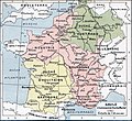
English: Francia at the death of Pepin of Heristal, 714
Français : Gaule à l'avènement de Charles Martel (714).
ڕێکەوت
سەرچاوە Paul Vidal de la Blache's Atlas général d'histoire et de géographie (1912). The original scanned image can be found at http://www.hipkiss.org/data/maps/vidal-lablache_atlas-general-histoire-et-geographie_1912_ancient-gaul-merovian-merovingienne_2953_4252_600.jpg. Information on the original scan can be found at http://www.hipkiss.org/cgi-bin/maps.pl?book=Vidal%20Lablache%20-%20Atlas%20General%20Histoire%20Et%20Geographie.
بەرھەمھێنەر
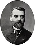
Paul Vidal de La Blache  (1845–1918)  wikidata:Q311865 s:fr:Auteur:Paul Vidal de La Blache q:fr:Paul Vidal de La Blache
 
Paul Vidal de La Blache
ناوەکانی تر
Paul Vidal de la Blanche
وەسف French geographer و cartographer
ڕێکەوتی لەدایکبوون/مردن ٢٢ی کانوونی دووەمی ١٨٤٥ Edit this at Wikidata ٥ی نیسانی ١٩١٨ Edit this at Wikidata
شوێنی لەدایکبوون/مردن Pézenas La Seyne-sur-Mer
کۆنتڕۆڵی دەسەڵات
creator QS:P170,Q311865
وەشانەکانی تر

مۆڵەتنامە

This image is in the public domain because it is a mere mechanical scan or photocopy of a public domain original, or – from the available evidence – is so similar to such a scan or photocopy that no copyright protection can be expected to arise. The original itself is in the public domain for the following reason:
Public domain

The author died in 1918, so this work is in the public domain in its country of origin and other countries and areas where the copyright term is the author's life plus 100 years or fewer.


This work is in the public domain in the United States because it was published (or registered with the U.S. Copyright Office) before January 1, 1929.


This tag is designed for use where there may be a need to assert that any enhancements (eg brightness, contrast, colour-matching, sharpening) are in themselves insufficiently creative to generate a new copyright. It can be used where it is unknown whether any enhancements have been made, as well as when the enhancements are clear but insufficient. For known raw unenhanced scans you can use an appropriate {{PD-old}} tag instead. For usage, see Commons:When to use the PD-scan tag.


Note: This tag applies to scans and photocopies only. For photographs of public domain originals taken from afar, {{PD-Art}} may be applicable. See Commons:When to use the PD-Art tag.

Original upload log

The original description page is/was here. All following user names refer to en.wikipedia.

  • 2007-08-19 21:33 Srnec 1241×1136×8 (353954 bytes) The map comes from Vidal-Lablache, ''Atlas général d'histoire et de géographie'' (1894). {{PD-art-life-70}}
  • 2007-09-10 16:34 Earthsound 1254 × 1149×8 (1 MB) Gaule at the time of Charles Martel (714). The scale is 1:12,000,000 This is a straightened and color balanced crop of a scan of a map from Paul Vidal de la Blache's 'Atlas général d'histoire et de géograp. {{PD-art-life-70}}

لێدوانەکان

Add a one-line explanation of what this file represents

بەندەکانی لەم پەڕگەیەدا دەردەکەون

depicts ئینگلیزی

مێژووی پەڕگە

کرتە بکە لەسەر یەکێک لە ڕێکەوت/کاتەکان بۆ بینینی پەڕگەکە بەو شێوەی لەو کاتەدا بووە.

ڕێکەوت/کاتھێمائەندازەبەکارھێنەرتێبینی
هەنووکە‏١٤:٢٦، ٢١ی ئەیلوولی ٢٠١٩ھێما بۆ وەشانی  ‏١٤:٢٦، ٢١ی ئەیلوولی ٢٠١٩١٬٢٥٤ لە ١٬١٤٩ (١ مێگابایت)OgreBot(BOT): Reverting to most recent version before archival
‏١٤:٢٦، ٢١ی ئەیلوولی ٢٠١٩ھێما بۆ وەشانی  ‏١٤:٢٦، ٢١ی ئەیلوولی ٢٠١٩١٬٢٤١ لە ١٬١٤٨ (٣٤٩ کیلۆبایت)OgreBot(BOT): Uploading old version of file from en.wikipedia; originally uploaded on 2007-08-19 21:41:17 by Srnec
‏١٩:٢٣، ٢٢ی کانوونی دووەمی ٢٠٠٨ھێما بۆ وەشانی  ‏١٩:٢٣، ٢٢ی کانوونی دووەمی ٢٠٠٨١٬٢٥٤ لە ١٬١٤٩ (١ مێگابایت)Vladimir Solovjev{{Information |Description={{en|This is a straightened and color balanced crop of a scan of a map from Paul Vidal de la Blache's ''Atlas général d'histoire et de géographie'' (1912).}} |Source=Transfered from [http://en.wikipedia.org

ئەم پەڕەیە ئەم پەڕگەیە بەکار دەھێنێت:

بەکارھێنانی سەرانسەریی پەڕگە

ئەم ویکیانەی دیکەی خوارەوەش ئەم پەڕگە بەکاردێنن:

بینینی بەکارھێنانی گشتی زیاتری ئەم پەڕگەیە.