
پەڕگە:FallingwaterEaves.jpg
قەبارەی ئەم پێشبینینە: ٣٨٩ لە ٥٩٩ پیکسەڵ. ڕێزەلووشنەکانی تر: ١٥٦ لە ٢٤٠ پیکسەڵ | ٤٩٤ لە ٧٦١ پیکسەڵ.
پەڕگەی سەرەکی (٤٩٤ × ٧٦١ پیکسڵ، قەبارەی پەڕگە: ٣٣٢ کیلۆبایت، جۆری ئێم ئای ئێم ئی: image/jpeg)
کورتە
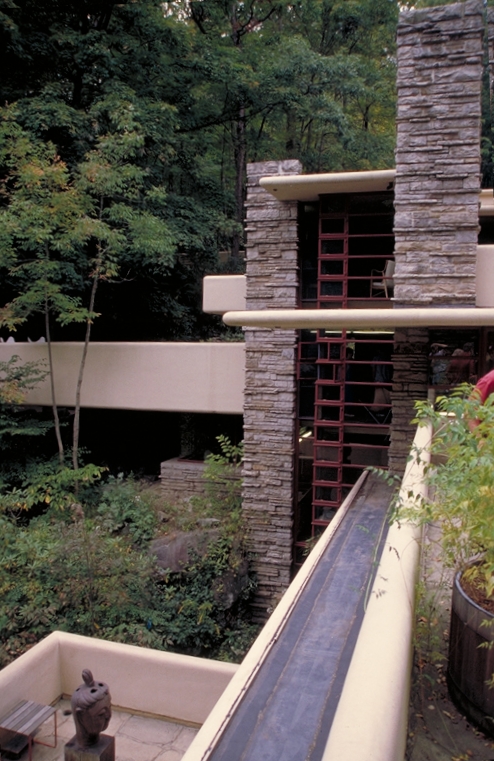
| وەسف |
English: Eaves and artwork of Fallingwater. |
| سەرچاوە | http://www.fhwa.dot.gov/byways/photos/50565 |
| بەرھەمھێنەر | Dennis Adams, Federal Highway Administration |
| Object location | | View this and other nearby images on: OpenStreetMap |
|---|
مۆڵەتنامە
| This image is a work of a United States Department of Transportation employee, taken or made as part of that person's official duties. As a work of the U.S. federal government, the image is in the public domain. |
مێژووی پەڕگە
کرتە بکە لەسەر یەکێک لە ڕێکەوت/کاتەکان بۆ بینینی پەڕگەکە بەو شێوەی لەو کاتەدا بووە.
| ڕێکەوت/کات | ھێما | ئەندازە | بەکارھێنەر | تێبینی | |
|---|---|---|---|---|---|
| هەنووکە | ١٠:٢٦، ٢٣ی تشرینی دووەمی ٢٠١٣ | | ٤٩٤ لە ٧٦١ (٣٣٢ کیلۆبایت) | Finavon | rotated |
| ١٥:٥٩، ٦ی نیسانی ٢٠٠٦ |  | ٥١٢ لە ٧٦٨ (٤٤١ کیلۆبایت) | Holly Cheng | Eaves and artwork of Fallingwater. Source: http://library.byways.org/download.html?DOWNLOAD_ID=1144273144&FILE_ID= |
بەکارھێنانی پەڕگە
ئەم پەڕەی 3ە ئەم پەڕگەیە بەکار دەھێنێت:
بەکارھێنانی سەرانسەریی پەڕگە
ئەم ویکیانەی دیکەی خوارەوەش ئەم پەڕگە بەکاردێنن:
- بەکارھێنان لە ast.wikipedia.org
- بەکارھێنان لە ba.wikipedia.org
- بەکارھێنان لە bn.wikipedia.org
- بەکارھێنان لە ca.wikipedia.org
- بەکارھێنان لە en.wikipedia.org
- بەکارھێنان لە es.wikipedia.org
- بەکارھێنان لە fa.wikipedia.org
- بەکارھێنان لە fi.wikipedia.org
- بەکارھێنان لە he.wikipedia.org
- بەکارھێنان لە hy.wikipedia.org
- بەکارھێنان لە id.wikipedia.org
- بەکارھێنان لە pt.wikipedia.org
- بەکارھێنان لە ru.wikipedia.org
- بەکارھێنان لە simple.wikipedia.org
- بەکارھێنان لە uk.wikipedia.org