
پەڕگە:Dominican Republic relief location map.jpg

قەبارەی ئەم پێشبینینە: ٧٣٧ لە ٥٩٩ پیکسەڵ. ڕێزەلووشنەکانی تر: ٢٩٥ لە ٢٤٠ پیکسەڵ | ٥٩٠ لە ٤٨٠ پیکسەڵ | ٩٤٥ لە ٧٦٨ پیکسەڵ | ١٬٢٥٩ لە ١٬٠٢٤ پیکسەڵ | ١٬٣٣٨ لە ١٬٠٨٨ پیکسەڵ.
پەڕگەی سەرەکی (١٬٣٣٨ × ١٬٠٨٨ پیکسڵ، قەبارەی پەڕگە: ٤٠٣ کیلۆبایت، جۆری ئێم ئای ئێم ئی: image/jpeg)
کورتە
| وەسف |
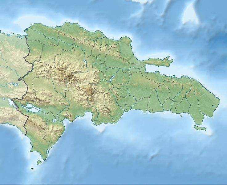
Deutsch: Physische Positionskarte Dominikanische Republik mit Provinzen, Quadratische Plattkarte, N-S-Streckung 105 %. Geographische Begrenzung der Karte:
English: Physical Location map Dominican Republic with Provinces, Equirectangular projection, N/S stretching 105 %. Geographic limits of the map:
|
||
| ڕێکەوت | |||
| سەرچاوە | بەرھەمی خۆم, SRTM3, ETOPO1, VMAP0, http://www.one.gob.do, http://lib.utexas.edu/maps/dominican_republic.html | ||
| بەرھەمھێنەر | Alexrk2 | ||
| وەشانەکانی تر |
|
||
| JPG genesis |
|


مۆڵەتنامە
من، ھەڵگری مافی لەبەرگرتنەوەی ئەم بەرھەمە، لەژێر ئەم مۆڵەتنامەیەدا بڵاوی دەکەمەوە:
ئەم پەڕگەیە لە ژێر مۆڵەتنامەی
Creative Commons Attribution-Share Alike 3.0 Unported دایە.
- تۆ ئازادی:
- بۆ بڵاکردنەوە – بۆ کۆپی کردن، دابەشکردن و دەستبەدەست ناردنی
- بۆ تێکەڵکردنەوە – بۆ سازاندنی کارەکە
- بەم مەرجانەی خوارەوە:
- دانەپاڵ – پێویستە باوەڕی گونجاو بدەیت، بەستەرێک بۆ مۆڵەتەکە دابین بکەیت و ئاماژە بەوە بکەیت کە ئایا گۆڕانکاری کراوە یان نا. دەتوانیت بە هەر شێوەیەکی گونجاو ئەوە بکەیت، بەڵام بە شێوەیەک نا کە وا دەربکەوێت کە مۆڵەتدەر پشتگیری تۆ یان بەکارهێنانەکەت بکات.
- بڵاوکردنەوەی گونجاو – ئەگەر لەسەر بنەمای ئەم کارە تێکەڵ، گۆڕان، یان ساز بکەی، پێویستە بەشدارییەکانت بە هەمان مۆڵەت یان هاوشێوەی مۆڵەتی ئەسڵی دابەش بکەی.
مێژووی پەڕگە
کرتە بکە لەسەر یەکێک لە ڕێکەوت/کاتەکان بۆ بینینی پەڕگەکە بەو شێوەی لەو کاتەدا بووە.
| ڕێکەوت/کات | ھێما | ئەندازە | بەکارھێنەر | تێبینی | |
|---|---|---|---|---|---|
| هەنووکە | ١٧:٣٦، ٨ی شوباتی ٢٠١٠ | | ١٬٣٣٨ لە ١٬٠٨٨ (٤٠٣ کیلۆبایت) | Alexrk2 | == Summary == {{Information |Description= {{de|Physische Positionskarte Dominikanische Republik mit Provinzen, Quadratische Plattkarte, N-S-Streckung 105 %. Geographische Begrenzung der Karte:}} {{en|Physical Location map |
بەکارھێنانی پەڕگە
ئەم پەڕەیە ئەم پەڕگەیە بەکار دەھێنێت:
بەکارھێنانی سەرانسەریی پەڕگە
ئەم ویکیانەی دیکەی خوارەوەش ئەم پەڕگە بەکاردێنن:
- بەکارھێنان لە af.wikipedia.org
- بەکارھێنان لە ar.wikipedia.org
- بەکارھێنان لە ast.wikipedia.org
- بەکارھێنان لە az.wikipedia.org
- بەکارھێنان لە ba.wikipedia.org
- بەکارھێنان لە be.wikipedia.org
- بەکارھێنان لە bg.wikipedia.org
- بەکارھێنان لە bn.wikipedia.org
- بەکارھێنان لە bs.wikipedia.org
- بەکارھێنان لە ca.wikipedia.org
- بەکارھێنان لە ceb.wikipedia.org
- بەکارھێنان لە ce.wikipedia.org
- بەکارھێنان لە cs.wikipedia.org
- بەکارھێنان لە da.wikipedia.org
- بەکارھێنان لە de.wikipedia.org
- Dominikanische Republik
- Pico Duarte
- Isla Saona
- Vorlage:Positionskarte Dominikanische Republik
- Wikipedia:Kartenwerkstatt/Positionskarten/Nordamerika
- Isla Beata
- Sierra de Neiba
- Isla Alto Velo
- Isla Catalinita
- Isla Catalina
- Lago Enriquillo
- Cordillera Central (Hispaniola)
- Bucht von Samaná
- El Morro de Montecristi
بینینی بەکارھێنانی گشتی زیاتری ئەم پەڕگەیە.