
پەڕگە:Canary A2002186 1155 250m.jpg

قەبارەی ئەم پێشبینینە: ٤٦٣ لە ٥٩٩ پیکسەڵ. ڕێزەلووشنەکانی تر: ١٨٥ لە ٢٤٠ پیکسەڵ | ٣٧١ لە ٤٨٠ پیکسەڵ | ٥٩٣ لە ٧٦٨ پیکسەڵ | ٧٩١ لە ١٬٠٢٤ پیکسەڵ | ١٬٥٨٢ لە ٢٬٠٤٨ پیکسەڵ | ٣٬٤٠٠ لە ٤٬٤٠٠ پیکسەڵ.
پەڕگەی سەرەکی (٣٬٤٠٠ × ٤٬٤٠٠ پیکسڵ، قەبارەی پەڕگە: ١٫٨٩ مێگابایت، جۆری ئێم ئای ئێم ئی: image/jpeg)
کورتە
| وەسف |
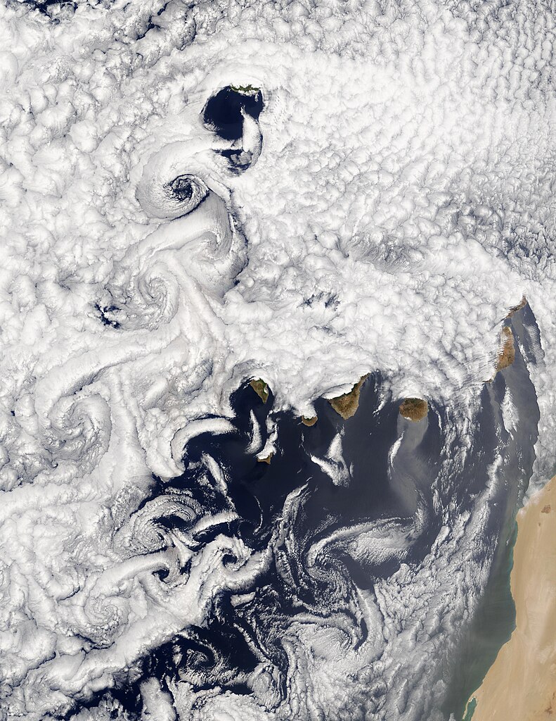
English: A vortex street often occurs when cloud formations over the ocean are disturbed by wind passing over land or another obstacle. In this true-color Moderate Resolution Imaging Spectroradiometer (MODIS) image from July 5, 2002, marine stratocumulus clouds have arranged themselves in rows, or streets, which are usually parallel to the direction of wind flow. Downwind of obstacles, in this case, the Canary Islands off the west African coast, eddies create turbulent patterns called vortex streets.
Español: Una calle del vórtice ocurre a menudo cuando las formaciones de nubes sobre el océano son perturbadas por el viento que pasa sobre la tierra u otro obstáculo. En este color verdadero Moderate Resolution Imaging Spectroradiometer (MODIS) de la imagen del 5 de julio de 2002, las nubes estratocúmulos marinos han dispuestas en filas o en las calles, que suelen ser paralelas a la dirección del flujo del viento. A sotavento de obstáculos, en este caso, las Islas Canarias frente a la costa oeste de África, los remolinos turbulentos crear patrones llamados calles vórtice. |
| ڕێکەوت | |
| سەرچاوە | https://visibleearth.nasa.gov/view.php?id=60766 |
| بەرھەمھێنەر | Jacques Descloitres, MODIS Land Rapid Response Team, NASA/GSFC |
مۆڵەتنامە
| This file is in the public domain in the United States because it was solely created by NASA. NASA copyright policy states that "NASA material is not protected by copyright unless noted". (See Template:PD-USGov, NASA copyright policy page or JPL Image Use Policy.) | ||
 |
Warnings:
|
مێژووی پەڕگە
کرتە بکە لەسەر یەکێک لە ڕێکەوت/کاتەکان بۆ بینینی پەڕگەکە بەو شێوەی لەو کاتەدا بووە.
| ڕێکەوت/کات | ھێما | ئەندازە | بەکارھێنەر | تێبینی | |
|---|---|---|---|---|---|
| هەنووکە | ١٦:٣٩، ٢٩ی نیسانی ٢٠٠٧ | | ٣٬٤٠٠ لە ٤٬٤٠٠ (١٫٨٩ مێگابایت) | Pepelopex | {{es|Efecto de los vientos alisios en la formación de nubes (estratocúmulus) en la vertiente norte de las Islas Canarias. Imagen del sistema MODIS de la NASA en color verdadero tomada el 5.07.2002.}} {{en|A vortex street often occurs when cloud formati |
بەکارھێنانی پەڕگە
ئەم پەڕەیە ئەم پەڕگەیە بەکار دەھێنێت:
بەکارھێنانی سەرانسەریی پەڕگە
ئەم ویکیانەی دیکەی خوارەوەش ئەم پەڕگە بەکاردێنن:
- بەکارھێنان لە ar.wikipedia.org
- بەکارھێنان لە ca.wikipedia.org
- بەکارھێنان لە en.wikipedia.org
- بەکارھێنان لە es.wikipedia.org
- بەکارھێنان لە fr.wikipedia.org
- بەکارھێنان لە ga.wikipedia.org
- بەکارھێنان لە ja.wikipedia.org
- بەکارھێنان لە nn.wikipedia.org
- بەکارھێنان لە pt.wikipedia.org