
پەڕگە:Canada provinces evolution 2.gif

قەبارەی ئەم پێشبینینە: ٦٩٤ لە ٦٠٠ پیکسەڵ. ڕێزەلووشنەکانی تر: ٢٧٨ لە ٢٤٠ پیکسەڵ | ٥٥٦ لە ٤٨٠ پیکسەڵ | ١٬٠٠٠ لە ٨٦٤ پیکسەڵ.
پەڕگەی سەرەکی (١٬٠٠٠ × ٨٦٤ پیکسڵ، قەبارەی پەڕگە: ٢٤٣ کیلۆبایت، جۆری ئێم ئای ئێم ئی: image/gif، looped، ٢٠ frames، ١خ ١٣چ)

|
This image could be re-created using vector graphics as an SVG file. This has several advantages; see Commons:Media for cleanup for more information. If an SVG form of this image is available, please upload it and afterwards replace this template with
{{vector version available|new image name}}.
It is recommended to name the SVG file "Canada provinces evolution 2.svg" - then the template Vector version available (or Vva) does not need the new image name parameter. |
|
کورتە
| وەسف |
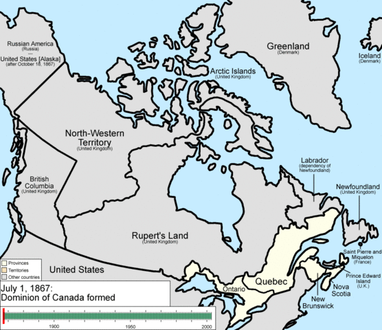
English: Animation of the changes to the borders of Canada.
The captions read as follows:
|
| ڕێکەوت | |
| سەرچاوە | بەرھەمی خۆم |
| بەرھەمھێنەر | Golbez |
مۆڵەتنامە
من، ھەڵگری مافی لەبەرگرتنەوەی ئەم بەرھەمە، لەژێر ئەم مۆڵەتنامەیانەدا بڵاوی دەکەمەوە:
ئەم پەڕگەیە لە ژێر مۆڵەتنامەی
Creative Commons Attribution-Share Alike 3.0 Unported دایە.
- تۆ ئازادی:
- بۆ بڵاکردنەوە – بۆ کۆپی کردن، دابەشکردن و دەستبەدەست ناردنی
- بۆ تێکەڵکردنەوە – بۆ سازاندنی کارەکە
- بەم مەرجانەی خوارەوە:
- دانەپاڵ – پێویستە باوەڕی گونجاو بدەیت، بەستەرێک بۆ مۆڵەتەکە دابین بکەیت و ئاماژە بەوە بکەیت کە ئایا گۆڕانکاری کراوە یان نا. دەتوانیت بە هەر شێوەیەکی گونجاو ئەوە بکەیت، بەڵام بە شێوەیەک نا کە وا دەربکەوێت کە مۆڵەتدەر پشتگیری تۆ یان بەکارهێنانەکەت بکات.
- بڵاوکردنەوەی گونجاو – ئەگەر لەسەر بنەمای ئەم کارە تێکەڵ، گۆڕان، یان ساز بکەی، پێویستە بەشدارییەکانت بە هەمان مۆڵەت یان هاوشێوەی مۆڵەتی ئەسڵی دابەش بکەی.

|
ڕێگەدراوە بە لەبەرگرتنەوە، دابەشکردن ھەروەھا/یان سازاندنی ئەم بەڵگەنامەیە لەژێر مەرجی مۆڵەتی GNU بۆ بەڵگەنامەی ئازاد، وەشانی ١.٢ یان ھەر وەشانێکی تری دواتر کە بڵاوکراوەتەوە لەلایەن دامەزراوەی بەرنامەی ئازاد، بەبێ ھیچ بەشێکی جیاواز، بەبێ نووسین لەسەر بەرگی پێشەوە و دواوەی. وێنەیەک لەمۆڵەتەکە لە بەشێکدا ھەیە کە ناوی مۆڵەتی GNU بۆ بەڵگەنامەی ئازادە. |
دەتوانی مۆڵەتنامەی دڵخوازت ھەڵبژێریت.
مێژووی پەڕگە
کرتە بکە لەسەر یەکێک لە ڕێکەوت/کاتەکان بۆ بینینی پەڕگەکە بەو شێوەی لەو کاتەدا بووە.
| ڕێکەوت/کات | ھێما | ئەندازە | بەکارھێنەر | تێبینی | |
|---|---|---|---|---|---|
| هەنووکە | ٢٢:٣٧، ١٤ی تەممووزی ٢٠٠٩ | | ١٬٠٠٠ لە ٨٦٤ (٢٤٣ کیلۆبایت) | Golbez | {{Information |Description=Animation of the changes to the borders of Canada. |Source=self-made |Date=July 15, 2009 |Author= Golbez |Permission= |other_versions= }} Category:Maps of the history of Canada Category:Animated GIF [[Ca |
بەکارھێنانی پەڕگە
ئەم پەڕەی 2ە ئەم پەڕگەیە بەکار دەھێنێت:
بەکارھێنانی سەرانسەریی پەڕگە
ئەم ویکیانەی دیکەی خوارەوەش ئەم پەڕگە بەکاردێنن:
- بەکارھێنان لە ar.wikipedia.org
- بەکارھێنان لە be-tarask.wikipedia.org
- بەکارھێنان لە bg.wikipedia.org
- بەکارھێنان لە ca.wikipedia.org
- بەکارھێنان لە cs.wikipedia.org
- بەکارھێنان لە en.wikipedia.org
- John A. Macdonald
- Manitoba
- Northwest Territories
- Ontario
- History of Canada
- Provinces and territories of Canada
- Talk:Labrador
- List of proposed provinces and territories of Canada
- Quebec Boundaries Extension Act, 1912
- History of Alberta
- Quebec Boundary Extension Act, 1898
- History of Western civilization
- Wikipedia:Featured pictures thumbs/06
- Canada
- Talk:Territorial evolution of Canada
- List of Canada-related topics by provinces and territories
- Demographics of the Northwest Territories
- Speaker of the Legislative Assembly of the Northwest Territories
- Portal:Canada/Selected picture
- Wikipedia:Featured pictures/Diagrams, drawings, and maps/Maps
- Wikipedia:Featured picture candidates/delist/2009
- Wikipedia:Featured picture candidates/delist/Canada provinces evolution.gif
- Talk:History of Canada/Archive 1
- Wikipedia:Featured picture candidates/November-2009
- Wikipedia:Featured picture candidates/Non-Native American Nations Control over N America 1750-2008.gif
- User:North8000
- User:Ezekiel11324/bordercity
- Former colonies and territories in Canada
- User:Soulscanner/Sandbox/CanHist
- Wikipedia:Reference desk/Archives/Miscellaneous/2011 August 15
- User talk:Golbez/Archive 6
- Template:POTD/2015-07-01
- Wikipedia:Picture of the day/July 2015
- Wikipedia:Main Page history/2015 July 1
- User:PMK2000/sandbox/Canada
- Timeline of Alberta history
- بەکارھێنان لە en.wikibooks.org
- بەکارھێنان لە es.wikipedia.org
بینینی بەکارھێنانی گشتی زیاتری ئەم پەڕگەیە.