
پەڕگە:BlueLine ver2.jpg

قەبارەی ئەم پێشبینینە: ٨٠٠ لە ٥٥٣ پیکسەڵ. ڕێزەلووشنەکانی تر: ٣٢٠ لە ٢٢١ پیکسەڵ | ٦٤٠ لە ٤٤٢ پیکسەڵ | ١٬٠٢٤ لە ٧٠٨ پیکسەڵ | ١٬٢٩٩ لە ٨٩٨ پیکسەڵ.
پەڕگەی سەرەکی (١٬٢٩٩ × ٨٩٨ پیکسڵ، قەبارەی پەڕگە: ٢٣٨ کیلۆبایت، جۆری ئێم ئای ئێم ئی: image/jpeg)

|
This military map image could be re-created using vector graphics as an SVG file. This has several advantages; see Commons:Media for cleanup for more information. If an SVG form of this image is available, please upload it and afterwards replace this template with
{{vector version available|new image name}}.
It is recommended to name the SVG file “BlueLine ver2.svg”—then the template Vector version available (or Vva) does not need the new image name parameter. |


کورتە
| وەسف |
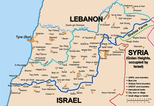
English: Map showing the Blue Line demarcation line between Lebanon and Israel, established by the UN after the Israeli withdrawal from southern Lebanon after its short 1978 invasion called "Operation Litani". It follows the 1949 cease-fire line, also known as the Green Line, as well as the somewhat contested Lebanese-Syrian border towards the Israeli-occupied Golan Heights. The map is made by Thomas Blomberg, using the UNIFIL map, deployment as of July 2006 as source.
Español: Sumario. Mapa mostrando a la línea de demarcación de Línea Azul entre Líbano y Israel, establecido por las Naciones Unidas después de la retirada israelí de Líbano del sur después de su invasión de 1978 corta llamada " Operación Litani ". Esto sigue la línea de alto el fuego 1949, también sabida(conocida) como la Línea Verde, así como la frontera algo impugnada libanesa siria hacia Altos del Golán Ocupados por israelí. El mapa es hecho por Thomas Blomberg, usando el mapa de UNIFIL, el despliegue desde el julio de 2006 como la fuente |
| ڕێکەوت | |
| سەرچاوە |
|
| بەرھەمھێنەر | Thomas Blomberg |
| وەشانەکانی تر |
|

مۆڵەتنامە
Thomas Blomberg، ھەڵگری مافی لەبەرگرتنەوەی ئەم بەرھەمە، لەژێر ئەم مۆڵەتنامەیەدا بڵاوی دەکاتەوە:
This file is licensed under the Creative Commons Attribution-Share Alike 2.5 Generic license.
دانەپاڵ: Thomas Blomberg
- تۆ ئازادی:
- بۆ بڵاکردنەوە – بۆ کۆپی کردن، دابەشکردن و دەستبەدەست ناردنی
- بۆ تێکەڵکردنەوە – بۆ سازاندنی کارەکە
- بەم مەرجانەی خوارەوە:
- دانەپاڵ – پێویستە باوەڕی گونجاو بدەیت، بەستەرێک بۆ مۆڵەتەکە دابین بکەیت و ئاماژە بەوە بکەیت کە ئایا گۆڕانکاری کراوە یان نا. دەتوانیت بە هەر شێوەیەکی گونجاو ئەوە بکەیت، بەڵام بە شێوەیەک نا کە وا دەربکەوێت کە مۆڵەتدەر پشتگیری تۆ یان بەکارهێنانەکەت بکات.
- بڵاوکردنەوەی گونجاو – ئەگەر لەسەر بنەمای ئەم کارە تێکەڵ، گۆڕان، یان ساز بکەی، پێویستە بەشدارییەکانت بە هەمان مۆڵەت یان هاوشێوەی مۆڵەتی ئەسڵی دابەش بکەی.
مێژووی پەڕگە
کرتە بکە لەسەر یەکێک لە ڕێکەوت/کاتەکان بۆ بینینی پەڕگەکە بەو شێوەی لەو کاتەدا بووە.
| ڕێکەوت/کات | ھێما | ئەندازە | بەکارھێنەر | تێبینی | |
|---|---|---|---|---|---|
| هەنووکە | ٠١:٣٥، ١٦ی شوباتی ٢٠١٠ | | ١٬٢٩٩ لە ٨٩٨ (٢٣٨ کیلۆبایت) | Jarekt | == {{int:filedesc}} == {{Information |Description= {{en|Map showing the Blue Line demarcation line between Lebanon and Israel, established by the UN after the Israeli withdrawal from southern Lebanon |
بەکارھێنانی پەڕگە
ئەم پەڕەیە ئەم پەڕگەیە بەکار دەھێنێت:
بەکارھێنانی سەرانسەریی پەڕگە
ئەم ویکیانەی دیکەی خوارەوەش ئەم پەڕگە بەکاردێنن:
- بەکارھێنان لە ar.wikipedia.org
- بەکارھێنان لە bn.wikipedia.org
- بەکارھێنان لە ca.wikipedia.org
- بەکارھێنان لە en.wikipedia.org
- بەکارھێنان لە fa.wikipedia.org
- بەکارھێنان لە fr.wikipedia.org
- بەکارھێنان لە mzn.wikipedia.org
- بەکارھێنان لە nl.wikipedia.org
- بەکارھێنان لە www.wikidata.org