
پەڕگە:Arch of Reunification.jpg
قەبارەی ئەم پێشبینینە: ٨٠٠ لە ٥٢٩ پیکسەڵ. ڕێزەلووشنەکانی تر: ٣٢٠ لە ٢١١ پیکسەڵ | ٦٤٠ لە ٤٢٣ پیکسەڵ | ١٬٠٢٤ لە ٦٧٧ پیکسەڵ | ١٬١٦٢ لە ٧٦٨ پیکسەڵ.
پەڕگەی سەرەکی (١٬١٦٢ × ٧٦٨ پیکسڵ، قەبارەی پەڕگە: ٣٠٨ کیلۆبایت، جۆری ئێم ئای ئێم ئی: image/jpeg)
| وەسف |
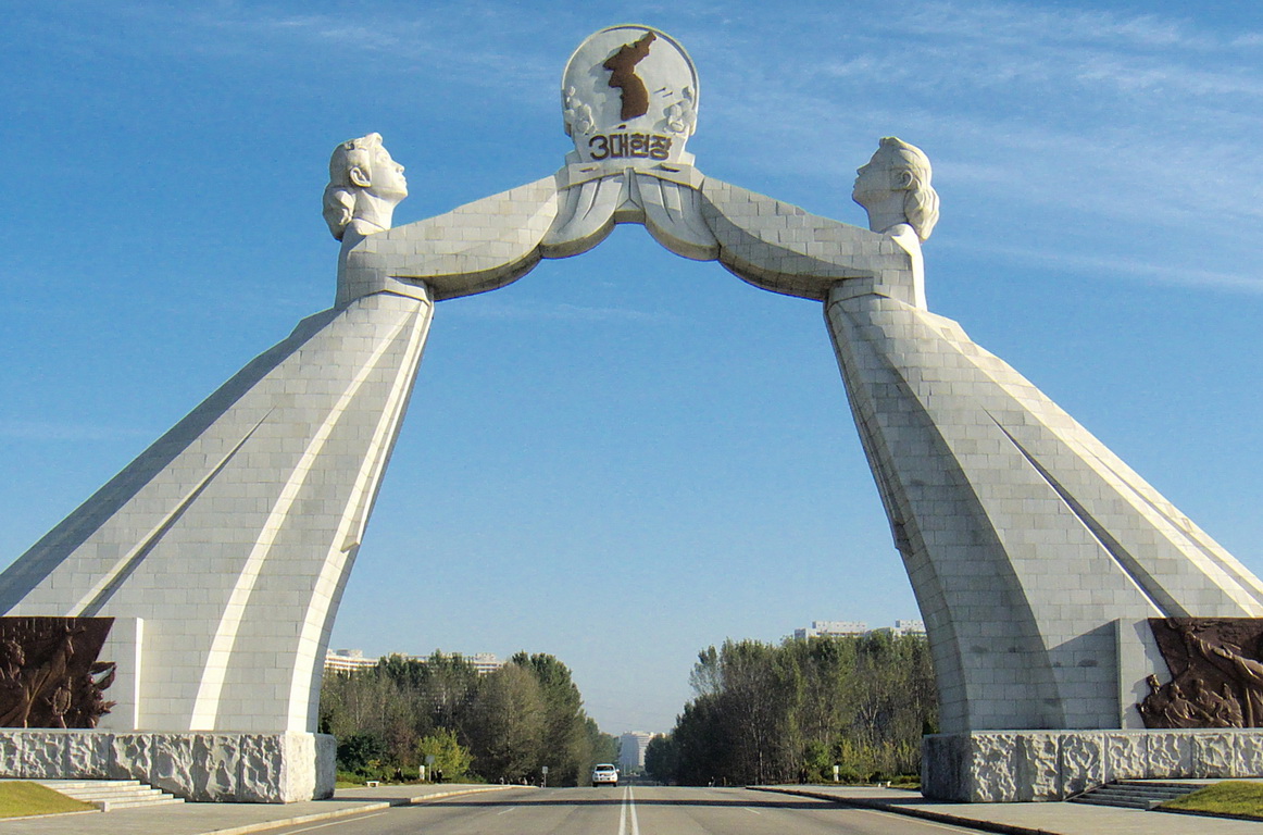
English: Featuring two Korean women in traditional garments reaching out to one another holding up a map of a unified Korea, the symbolism is obvious. Erected in 2001, the arch is sited rather aptly, on the Tongil expressway which leads straight to Panmunjom and eventually, Seoul. The three principles (formalized by Kim Il Sung during a meeting with the South in 1972) are independence, peaceful reunification and national unity. |
| ڕێکەوت | |
| سەرچاوە | Crop of Monument to Three Charters for National Reunification, Pyongyang, North Korea |
| بەرھەمھێنەر | Kok Leng Yeo from Singapore, Singapore |
| Camera location | | View this and other nearby images on: OpenStreetMap |
|---|
2024년 4월 27일 (토) 일정으로 저장됩니다.
مۆڵەتنامە
This file is licensed under the Creative Commons Attribution 2.0 Generic license.
- تۆ ئازادی:
- بۆ بڵاکردنەوە – بۆ کۆپی کردن، دابەشکردن و دەستبەدەست ناردنی
- بۆ تێکەڵکردنەوە – بۆ سازاندنی کارەکە
- بەم مەرجانەی خوارەوە:
- دانەپاڵ – پێویستە باوەڕی گونجاو بدەیت، بەستەرێک بۆ مۆڵەتەکە دابین بکەیت و ئاماژە بەوە بکەیت کە ئایا گۆڕانکاری کراوە یان نا. دەتوانیت بە هەر شێوەیەکی گونجاو ئەوە بکەیت، بەڵام بە شێوەیەک نا کە وا دەربکەوێت کە مۆڵەتدەر پشتگیری تۆ یان بەکارهێنانەکەت بکات.
| This image, originally posted to Flickr, was reviewed on 26 December 2008 by the administrator or reviewer MBisanz, who confirmed that it was available on Flickr under the stated license on that date. |
2024년 5월 3일 (금) 일정으로 저장됩니다.
مێژووی پەڕگە
کرتە بکە لەسەر یەکێک لە ڕێکەوت/کاتەکان بۆ بینینی پەڕگەکە بەو شێوەی لەو کاتەدا بووە.
| ڕێکەوت/کات | ھێما | ئەندازە | بەکارھێنەر | تێبینی | |
|---|---|---|---|---|---|
| هەنووکە | ١٧:١٢، ٢٥ی کانوونی یەکەمی ٢٠٠٨ | | ١٬١٦٢ لە ٧٦٨ (٣٠٨ کیلۆبایت) | Avala | {{Information |Description= Featuring two Korean women in traditional garments reaching out to one another holding up a map of a unified Korea, the symbolism is obvious. Erected in 2001, the arch is sited rather aptly, on the Tongil expressway which leads |
بەکارھێنانی پەڕگە
ئەم پەڕەیە ئەم پەڕگەیە بەکار دەھێنێت:
بەکارھێنانی سەرانسەریی پەڕگە
ئەم ویکیانەی دیکەی خوارەوەش ئەم پەڕگە بەکاردێنن:
- بەکارھێنان لە an.wikipedia.org
- بەکارھێنان لە ar.wikipedia.org
- بەکارھێنان لە ast.wikipedia.org
- بەکارھێنان لە bn.wikipedia.org
- بەکارھێنان لە bo.wikipedia.org
- بەکارھێنان لە ca.wikipedia.org
- بەکارھێنان لە da.wikipedia.org
- بەکارھێنان لە de.wikipedia.org
- بەکارھێنان لە en.wikipedia.org
- بەکارھێنان لە es.wikipedia.org
- بەکارھێنان لە eu.wikipedia.org
- بەکارھێنان لە fa.wikipedia.org
- بەکارھێنان لە fi.wikipedia.org
- بەکارھێنان لە fy.wikipedia.org
- بەکارھێنان لە id.wikipedia.org
- بەکارھێنان لە it.wikipedia.org
- بەکارھێنان لە it.wikivoyage.org
- بەکارھێنان لە ja.wikipedia.org
- بەکارھێنان لە jv.wikipedia.org
- بەکارھێنان لە km.wikipedia.org
- بەکارھێنان لە kn.wikipedia.org
- بەکارھێنان لە ko.wikipedia.org
- بەکارھێنان لە mai.wikipedia.org
- بەکارھێنان لە mn.wikipedia.org
- بەکارھێنان لە nl.wikipedia.org
- بەکارھێنان لە pl.wikipedia.org
- بەکارھێنان لە pt.wikipedia.org
- بەکارھێنان لە ru.wikivoyage.org
- بەکارھێنان لە sv.wikipedia.org
- بەکارھێنان لە th.wikipedia.org
- بەکارھێنان لە uk.wikipedia.org
- بەکارھێنان لە zh.wikipedia.org