
پەڕگە:Al-Idrisi's world map.JPG

پەڕگەی سەرەکی (١٬٤٢٤ × ١٬٥٥٢ پیکسڵ، قەبارەی پەڕگە: ٩١٧ کیلۆبایت، جۆری ئێم ئای ئێم ئی: image/jpeg)
|
کورتە
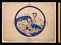
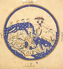
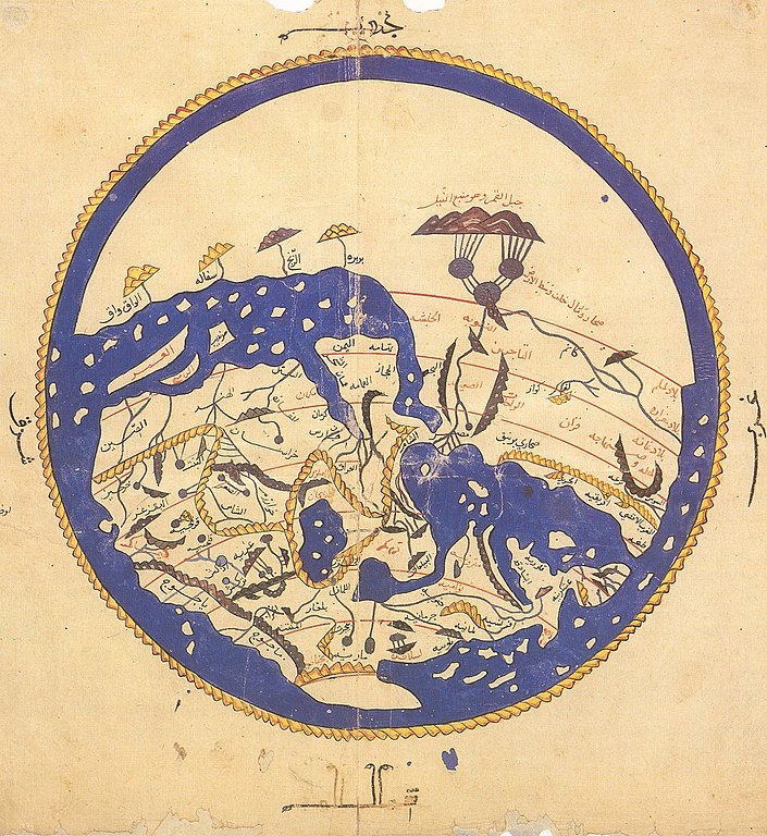
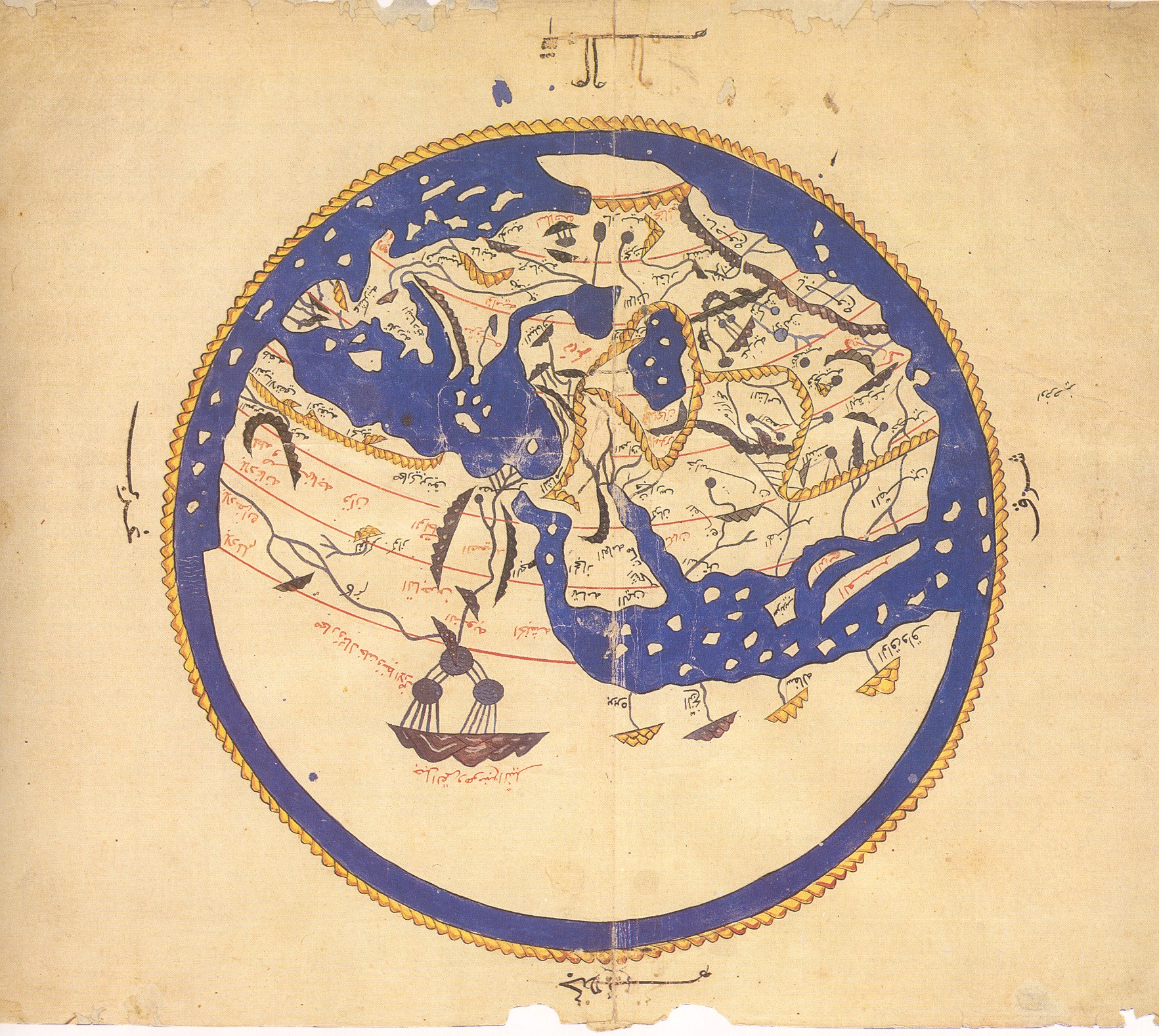
لاحظ كيف أنَّ الجنوب وُضع أعلى الخارطة.
- الخريطة معكوسة حيثُ أنَّ الجنوب في الأعلى
- في الملكيَّة العامَّة كونها قديمة لا تخضع لحقوق التأليف والنشر.
أُخذت النسخة الأولى من هذا الموقع، وتحديدًا من هُنا. أمَّا النسخة الثانية فقد تمَّ قلبها وقصَّها، وأصلها هُنا
وفقًا لمكتبة فرنسا الوطنيَّة، فإنَّ هُناك عشرُ نُسخٍ باقية من كتاب نزهة المشتاق في اختراق الآفاق أو كتاب روجر حول العالم. ومن بين هذه النُسخ العشر، فإنَّ ستَّة تضم خارطة مُستديرة في بداية المؤلَّف غير مذكورة في نص الإدريسي الأصلي". [1]
هذه الصورة مأخوذة من مخطوطة نسخها علي بن الحسن الحوفي القاسمي في القاهرة سنة م1456، يُحتفظُ بها الآن في مكتبة بودليايان بأكسفورد. (Mss. Pococke 375 fol. 3v-4)
مُلاحظة: الخارطة في الأعلى مغلوطة ومقلوبة رأسًا على عقب.
فلا تتشاطرها مع أحد عبر أي موقع أو في الواقع، واستبدلها بهذه النسخة
Note that south is at the top of the map.
The first version was uploaded from Henry Davis; the second rotated and cropped from an original at Sindominio.net. The original image is also available at the Bodleian here.Versions
-
 Rotated 180 degrees
 -
 Original picture.
 -
 This version (cropped).
 -
 More cropped.
 -
 Wikimedia user awards
 -
 English and Latin version.


مۆڵەتنامە
|
This is a faithful photographic reproduction of a two-dimensional, public domain work of art. The work of art itself is in the public domain for the following reason:
The official position taken by the Wikimedia Foundation is that "faithful reproductions of two-dimensional public domain works of art are public domain".
This photographic reproduction is therefore also considered to be in the public domain in the United States. In other jurisdictions, re-use of this content may be restricted; see Reuse of PD-Art photographs for details. | ||||
مێژووی پەڕگە
کرتە بکە لەسەر یەکێک لە ڕێکەوت/کاتەکان بۆ بینینی پەڕگەکە بەو شێوەی لەو کاتەدا بووە.
| ڕێکەوت/کات | ھێما | ئەندازە | بەکارھێنەر | تێبینی | |
|---|---|---|---|---|---|
| هەنووکە | ٠٣:٥٣، ٢٣ی ئابی ٢٠٠٦ | | ١٬٤٢٤ لە ١٬٥٥٢ (٩١٧ کیلۆبایت) | Leinad-Z~commonswiki | Losslessly rotaded and cropped from http://www.sindominio.net/labiblio/varios/IdrisiMap.jpg |
| ١٣:٥٥، ٨ی نیسانی ٢٠٠٥ |  | ٤٩٢ لە ٥٧٠ (٧٢ کیلۆبایت) | EugeneZelenko | Al-Idrisi's world map from 1154. Note that south is at the top of the map. Originally uploaded to English Wikipedia by en:User: SimonP (06:19, 8 Dec 2004). {{PD}} |
بەکارھێنانی پەڕگە
ئەم پەڕەیە ئەم پەڕگەیە بەکار دەھێنێت:
بەکارھێنانی سەرانسەریی پەڕگە
ئەم ویکیانەی دیکەی خوارەوەش ئەم پەڕگە بەکاردێنن:
- بەکارھێنان لە als.wikipedia.org
- بەکارھێنان لە ar.wikipedia.org
- بوابة:جغرافيا
- الإدريسي
- خرائطية
- الواق واق
- خريطة
- بوابة:علوم/صورة مختارة
- نزهة المشتاق في اختراق الآفاق
- بربرة (الصومال)
- مستخدم:Ibrahim.ID/سجل الأعمال
- ويكيبيديا:جائزة المنتج - النصف الأول لعام 2014/Ibrahim.ID
- ويكيبيديا:ترشيحات الصور المختارة/خريطة الإدريسي
- بوابة:جغرافيا/صورة مختارة/1
- بوابة:جغرافيا/صورة مختارة/أرشيف
- ويكيبيديا:صور مختارة/رسومات وجداول وخرائط/خرائط
- بوابة:التاريخ الإسلامي/صورة مختارة/أرشيف
- بوابة:التاريخ الإسلامي/صورة مختارة/7
- مستخدم:عبد المؤمن/مصور/تاريخ إسلامي
- ويكيبيديا:صورة اليوم المختارة/مايو 2016
- قالب:صورة اليوم المختارة/2016-05-10
- بوابة:علوم/صورة مختارة/11
- ويكيبيديا:صورة اليوم المختارة/يوليو 2017
- قالب:صورة اليوم المختارة/2017-07-26
- ويكيبيديا:صورة اليوم المختارة/يوليو 2019
- قالب:صورة اليوم المختارة/2019-07-05
- ويكيبيديا:صورة اليوم المختارة/مارس 2020
- قالب:صورة اليوم المختارة/2020-03-16
- مستخدم:Mounir Neddi
- ويكيبيديا:صورة اليوم المختارة/يناير 2023
- قالب:صورة اليوم المختارة/2023-01-15
- قالب:صورة اليوم المختارة/تخطيط/2023/يناير
- مستخدم:Mounir Neddi/الملف الشخصي/قسم إضافي علوي
- قالب:خبير في علم الخرائطية
- مستخدم:Bmt3s/ملعب/3
- بەکارھێنان لە ast.wikipedia.org
- بەکارھێنان لە be-tarask.wikipedia.org
- بەکارھێنان لە be.wikipedia.org
- بەکارھێنان لە bn.wikipedia.org
- بەکارھێنان لە br.wikipedia.org
- بەکارھێنان لە bs.wikipedia.org
- بەکارھێنان لە ca.wikipedia.org
بینینی بەکارھێنانی گشتی زیاتری ئەم پەڕگەیە.