
پەڕگە:Ain al-Assad air base, 8 jan 2020.png

قەبارەی ئەم پێشبینینە: ٨٠٠ لە ٤٥٣ پیکسەڵ. ڕێزەلووشنەکانی تر: ٣٢٠ لە ١٨١ پیکسەڵ | ٦٤٠ لە ٣٦٢ پیکسەڵ | ١٬٠٢٤ لە ٥٨٠ پیکسەڵ | ١٬٢٨٠ لە ٧٢٤ پیکسەڵ | ٢٬٠٠٠ لە ١٬١٣٢ پیکسەڵ.
پەڕگەی سەرەکی (٢٬٠٠٠ × ١٬١٣٢ پیکسڵ، قەبارەی پەڕگە: ٤٫٥ مێگابایت، جۆری ئێم ئای ئێم ئی: image/png)
کورتە
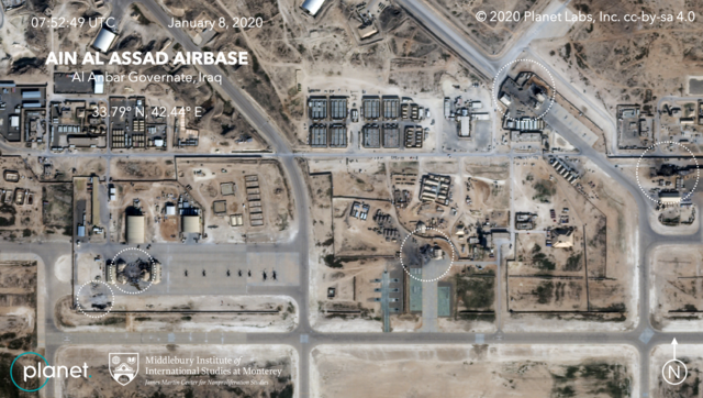
| وەسف | Satellite image, showing the damage to at least five structures at Ain al-Assad air base in Iraq in a series of precision missile strikes launched by Iran |
| ڕێکەوت | |
| سەرچاوە |
First upload: Brumfiel, Geoff; Welna, David (8 January 2020). Satellite Photos Reveal Extent Of Damage From Iranian Strike On Air Base In Iraq. NPR. Current upload: Garger, Kenneth (8 January 2020). Before-and-after satellite images show damage to Iraqi base hit by Iran. New York Post. |
| بەرھەمھێنەر | Planet Labs, Inc. / Middlebury Institute of International Studies at Monterey |
| ڕێپێدان (بەکارھێنانەوەی ئەم پەڕگەیە) |
There is a copyright notice in the upper right of this image. "© 2020 Planet Labs, Inc. cc-by-sa 4.0" |
مۆڵەتنامە
This file is licensed under the Creative Commons Attribution-Share Alike 4.0 International license.
دانەپاڵ: Planet Labs, Inc.
- تۆ ئازادی:
- بۆ بڵاکردنەوە – بۆ کۆپی کردن، دابەشکردن و دەستبەدەست ناردنی
- بۆ تێکەڵکردنەوە – بۆ سازاندنی کارەکە
- بەم مەرجانەی خوارەوە:
- دانەپاڵ – پێویستە باوەڕی گونجاو بدەیت، بەستەرێک بۆ مۆڵەتەکە دابین بکەیت و ئاماژە بەوە بکەیت کە ئایا گۆڕانکاری کراوە یان نا. دەتوانیت بە هەر شێوەیەکی گونجاو ئەوە بکەیت، بەڵام بە شێوەیەک نا کە وا دەربکەوێت کە مۆڵەتدەر پشتگیری تۆ یان بەکارهێنانەکەت بکات.
- بڵاوکردنەوەی گونجاو – ئەگەر لەسەر بنەمای ئەم کارە تێکەڵ، گۆڕان، یان ساز بکەی، پێویستە بەشدارییەکانت بە هەمان مۆڵەت یان هاوشێوەی مۆڵەتی ئەسڵی دابەش بکەی.
مێژووی پەڕگە
کرتە بکە لەسەر یەکێک لە ڕێکەوت/کاتەکان بۆ بینینی پەڕگەکە بەو شێوەی لەو کاتەدا بووە.
| ڕێکەوت/کات | ھێما | ئەندازە | بەکارھێنەر | تێبینی | |
|---|---|---|---|---|---|
| هەنووکە | ٠٦:١٤، ٩ی کانوونی دووەمی ٢٠٢٠ | | ٢٬٠٠٠ لە ١٬١٣٢ (٤٫٥ مێگابایت) | EnchanterTim | Higher resolution from: https://nypost.com/2020/01/08/before-and-after-satellite-images-show-damage-to-iraqi-base-hit-by-iran/ |
| ١٩:٥٢، ٨ی کانوونی دووەمی ٢٠٢٠ |  | ٨٠٠ لە ٤٤٩ (٨٠٥ کیلۆبایت) | Cold Season | {{Information |Description= Satellite image, showing the damage to at least five hangars and buildings at Ain al-Assad air base in Iraq in a series of precision missile strikes launched by Iran |Source= [https://www.npr.org/2020/01/08/794517031/satellite-photos-reveal-extent-of-damage-at-al-assad-air-base?t=1578512699906 Satellite Photos Reveal Extent Of Damage From Iranian Strike On Air Base In Iraq]. NPR. |Date= 8 January 2020 |Author= Planet Labs Inc./Middlebury Institute |Permission= |ot... |
بەکارھێنانی پەڕگە
ئەم پەڕەیە ئەم پەڕگەیە بەکار دەھێنێت:
بەکارھێنانی سەرانسەریی پەڕگە
ئەم ویکیانەی دیکەی خوارەوەش ئەم پەڕگە بەکاردێنن:
- بەکارھێنان لە ar.wikipedia.org
- بەکارھێنان لە be.wikipedia.org
- بەکارھێنان لە ca.wikipedia.org
- بەکارھێنان لە en.wikipedia.org
- بەکارھێنان لە es.wikipedia.org
- بەکارھێنان لە fa.wikipedia.org
- بەکارھێنان لە fi.wikipedia.org
- بەکارھێنان لە fr.wikipedia.org
- بەکارھێنان لە he.wikipedia.org
- بەکارھێنان لە id.wikipedia.org
- بەکارھێنان لە ja.wikipedia.org
- بەکارھێنان لە ka.wikipedia.org
- بەکارھێنان لە ko.wikipedia.org
- بەکارھێنان لە nl.wikipedia.org
- بەکارھێنان لە nl.wikinews.org
- بەکارھێنان لە pnb.wikipedia.org
- بەکارھێنان لە pt.wikipedia.org
- بەکارھێنان لە ru.wikipedia.org
- بەکارھێنان لە ru.wikinews.org
- بەکارھێنان لە so.wikipedia.org
- بەکارھێنان لە uk.wikipedia.org
- بەکارھێنان لە ur.wikipedia.org
- بەکارھێنان لە vi.wikipedia.org
- بەکارھێنان لە www.wikidata.org
- بەکارھێنان لە zh.wikipedia.org